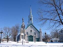
Saint-Augustin-de-Desmaures
| Saint-Augustin-de-Desmaures | ||
|---|---|---|
| City | ||
 | ||
| ||
 Location within Quebec TE. | ||
 Saint-Augustin-de-Desmaures Location in province of Quebec. | ||
| Coordinates: 46°44′N 71°28′W / 46.733°N 71.467°WCoordinates: 46°44′N 71°28′W / 46.733°N 71.467°W[1] | ||
| Country |
| |
| Province |
| |
| Region | Capitale-Nationale | |
| RCM | None | |
| Agglomeration | Quebec City | |
| Settled | 1679 | |
| Constituted | January 1, 2006 | |
| Government[2] | ||
| • Mayor | Sylvain Juneau | |
| • Federal riding | Portneuf—Jacques-Cartier | |
| • Prov. riding | Louis-Hébert | |
| Area[2][3] | ||
| • Total | 105.00 km2 (40.54 sq mi) | |
| • Land | 85.76 km2 (33.11 sq mi) | |
| Population (2011)[3] | ||
| • Total | 18,141 | |
| • Density | 211.5/km2 (548/sq mi) | |
| • Pop 2006-2011 |
| |
| • Dwellings | 6,632 | |
| Time zone | EST (UTC−5) | |
| • Summer (DST) | EDT (UTC−4) | |
| Postal code(s) | G3A | |
| Area code(s) | 418 and 581 | |
| Highways |
| |
| Website |
www.ville. st-augustin.qc.ca | |
Saint-Augustin-de-Desmaures is a city in central Quebec, Canada, on the Saint Lawrence River, adjacent to Quebec City.
The town was founded in 1691 by three families (Desroches, Racette, Couture). It was merged with Quebec City on January 1, 2002 as part of the 2000–2006 municipal reorganization in Quebec and became part of the Laurentien borough of that city. However, after a 2004 referendum it was re-established as a separate city on January 1, 2006.
The local post office was previously named Saint-Augustin-de-Portneuf from 1852, then Saint-Augustin-de-Québec from 1918 until this was renamed to the community's current name in 1986.[4]
Demographics
According to the Canada 2006 Census:[5]
- Population: 17,281
- % Change (2001-2006): +9.8
- Private dwellings occupied by usual residents: 6,431 (total dwellings: 6,632)
- Area (km²): 85.76 km²
- Density (persons per km²): 201.5
- Mother tongue:
- English as first language: 1.1%
- French as first language: 97.5%
- English and French as first language: 0.2%
- Other as first language: 1.2%
Population trend:[6]
- Population in 2011: 18,141 (2006 to 2011 population change: 5.0%)
- Population in 2006: 17,281
- Population in 2001: 15,732
- Population in 1996: 14,771
- Population in 1991: 12,680
In 2006, Saint-Augustin-de-Desmaures was 98.0% White, 0.5% Aboriginal, and 1.5% Visible Minorities.
See also
References
- ↑ Reference number 393811 of the Commission de toponymie du Québec (in French)
- 1 2 Ministère des Affaires municipales, des Régions et de l'Occupation du territoire - Répertoire des municipalités: Saint-Augustin-de-Desmaures
- 1 2 Statistics Canada 2011 Census - Saint-Augustin-de-Desmaures census profile
- ↑ (in French)Saint-Augustin-de-Desmaures at Commission de toponymie Québec
- ↑ Statistics Canada 2006 Census - Saint-Augustin-de-Desmaures community profile
- ↑ Statistics Canada: 1996, 2001, 2006, 2011 census
.svg.png)

