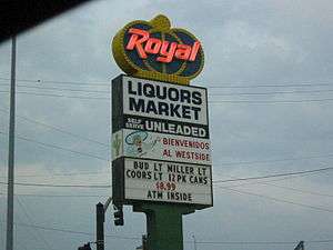
Southwest Boulevard (Kansas City)

Southwest Boulevard (simply known as "The Boulevard" locally) is an arterial street in Kansas City, MO and Kansas City, KS.
Description
On the north end Southwest Boulevard starts as 19th Street at Baltimore Avenue in Kansas City, MO, and travels southwest crossing the state line into Kansas City, KS at 31st Street and continues until crossing 39th Avenue at which point it continues as Merriam Lane. Southwest Boulevard passes through the Crossroads Arts District and the West Side Neighborhood in Missouri and also the Rosedale Neighborhood in Kansas. Throughout the Kansas City area, the Boulevard is known for its wide selection of authentic Mexican restaurants and grocery stores.[1][2] It is the home of the Boulevard Brewing Company which was founded in 1988 and is now one of the largest craft breweries in the USA, with a capacity of over 600,000 barrels per year.[3]
History
Southwest Boulevard originated as two roads, one being the main street of Rosedale, Kansas, when it was platted in 1872 as "Kansas City Avenue", and the second called "The Rosesale Road", or "Kansas City Boulevard", on the Missouri side.[4] Two property owners provided land to link the two roads in 1887, and the entire road was later renamed as "Southwest Boulevard."[4][5][6] One of those landowners was Simeon Bell, who later donated the land upon which Eleanor Taylor Bell Hospital was built on Southwest Boulevard, and which housed the University of Kansas medical school until the 1920s. The Rosedale-Kansas portion of the road was originally macadamized, and was paved in 1915.[5]
Part of the road used to be signed as U.S. 69[7] until the 18th Street Expressway was completed in the 1950s.
See also
- 39th Street (Kansas City)
- Linwood Boulevard (Kansas City)
- Prospect Avenue (Kansas City, Missouri)
- The Paseo (Kansas City)
References
- ↑ Patti DeLano (2008), Missouri Off the Beaten Path, p. 112, ISBN 9780762748747
- ↑ Katie Van Luchene (2010), Insiders' Guide to Kansas City, p. 64, ISBN 9780762753437
- ↑ Keith Villa (2011), The Oxford Companion to Beer, Oxford University Press, p. 155, ISBN 9780195367133
- 1 2 Southwest Boulevard - Merriam Lane Corridor Master Plan (2010)
- 1 2 Landis, Margaret. A History of the City of Rosedale, Ch. 10 - "Southwest Boulevard" (1976)
- ↑ Heeded Plaint of Motorists: Rutty Southwest Boulevard is to be made permanently smooth, The City Hall (October 1910, p. 160)
- ↑ Kansas, a Guide to the Sunflower State, p. 500 (1939)
External links
- Southwest Boulevard Photographs, Missouri Valley Special Collections, Kansas City Public Library
Coordinates: 39°5′17.29″N 94°35′18.33″W / 39.0881361°N 94.5884250°W