South Norwalk
| South Norwalk | |
|---|---|
| Taxing District | |
|
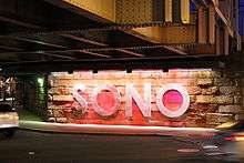
SoNo illuminated sign | |
 South Norwalk  South Norwalk | |
| Coordinates: 41°07′N 73°25′W / 41.11°N 73.42°W | |
| Country |
|
| State |
|
| County | Fairfield |
| City | Norwalk |
| Founded | August 18, 1870 |
| Incorporated with Norwalk | June 6, 1913 |
| ZIP code | 06854 |
| Area code(s) | Area codes 203 and 475 |
South Norwalk is a neighborhood and the Second Taxing District[1][2] in Norwalk, Connecticut. The neighborhood was originally a settlement called 'Old Well' which became chartered as the city of 'South Norwalk' on August 18, 1870. The cities of Norwalk and South Norwalk were incorporated on June 6, 1913.
The neighborhood is often referred to with the acronym 'SoNo',[3] referring to "the formerly rundown stretch of Washington Street between the Metro-North Railroad tracks and Norwalk Harbor."
SoNo South encompasses what state representative Joseph Mann, a Democrat who lives and works in the neighborhood, called "the real South Norwalk" in 2004 - the heavily minority, middle- to lower-class residential and industrial neighborhoods bordered on the north and south by Washington and Concord streets, and on the east and west by Water Street and Martin Luther King Drive."[4]
"SoNo, with its delightful mixture of classy and tasteful or just plain homey restaurants, shops, and clubs, combined with museums and galleries, has become integrated with greater Norwalk as well as the harbor and Long Island Sound beyond. SoNo is anchored by the Maritime Center, (present-day Maritime Aquarium at Norwalk) which invites visitors of all ages to become immersed in sea life. Exhibits, educational programs, research cruises, and a boat building shop, are topped off by the spectacular IMAX Theatre".[5][6]
South Norwalk is host of the annual SoNo Arts Celebration. The free event takes place every August and features over 100 fine art and craftsperson exhibits, as well as over 25 musical performances for all ages.
Boundaries
South Norwalk, or Norwalk 2nd Taxing District, borders are as follows:[7]
- North: From Connecticut Ave. near I95 exit 14 through Mathews Park to the Norwalk River.
- South: from Windsor Place on a line to South Main St. near the intersection of Meadow St. and on a line to Norwalk River.
- East: Through Norwalk River.
- West: From Connecticut Ave. near I95 exit 14 on a line to Windsor Place.
History
.jpg)
Old Well
"Sailing ships in the olden days pulled up to docks along the inner harbor and waited their turn to fill up their water casks from the “Old Well”. In a 1738 deed Washington Street is referred to as “the highway that leads to ye landing place called Ye Old Well. The actual well is shown on the Beers Atlas map of 1867[8] to be East of Water Street about 75 feet South of Washington Street. The exact location has been lost but is believed to have been very near to Donovan’s Tavern, which seems likely since sailors are said to have enjoyed the spirits. Old Well was involved in coastal trade, manufacturing, and shipbuilding as well as having many farms with diversified crops."[9]
“Old Well was scarcely a village in those days, but rather a group of farms, and the well which gave the place its name was on Water street, near the corner of Haviland street, on the property of Eliakim Raymond, a patriarch of several Norwalk lines. His house stood at the corner of Washington and Water streets before the Revolution and was burned with rest of the town."[10]
City of South Norwalk
"Norwalk was made a borough in 1836, and the village of Old Well, named from an ancient well where vessels were supplied with water, was incorporated into a city in 1868, and named South Norwalk two years afterward."[11] "South Norwalk, formerly called "Old Well" was organized a city August 18, 1870, under a charter granted by the Legislature of Connecticut, July 5th of the same year. This charter was revised by the Legislature April 19, 1882, and the city continued its existence under this revised charter until May 27, 1897, when the Legislature approved a revised and amended charter, under which the city has since continued and worked."[12][13]
"In the 1800s, industrialization started to take place--large factories manufacturing goods such as firearms, buttons, shoes, cloth and hats were increasing in Connecticut and in Norwalk. Workers came up from Chesapeake, Maryland, to work as oystermen. Wealthy owners and managers of businesses lived on Golden Hill overlooking South Norwalk. Immigrants came into Norwalk from many places. One of the largest [group] to come here in the early 1900s was the Hungarians; there were also many Eastern European Jews and Italians, among others."[14]
"In the city government consolidation of 1913, the City of South Norwalk became the Second Taxing District, but South Norwalk was brought into the consolidation against its will. South Norwalk had been incorporated in 1873 as a city within the Town of Norwalk and in the following half-century it became the economic center of Norwalk. With a port and a railroad, it was the center of Norwalk industry, providing employment to thousands of Norwalk factory workers.
"Prosperous and self-sufficient, the City of South Norwalk had little financial incentive to join in the 1913 consolidation. Its residents feared higher taxes if they lost their city status. In 1902 South Norwalk had tried to leave the Town of Norwalk entirely, and, along with East Norwalk, become a completely separate Town. At the time Mayor Mortimer M. Lee said that South Norwalk had “a large water system, a splendid electric light plant, a separate sewer system, a public library and a library building and schools second to none.” In 1903 the Connecticut State legislature passed a bill to create the independent Town of South Norwalk, but it was vetoed by the governor."[15](Abiram Chamberlain)[16]
National Register of Historic Places

- Beth Israel Synagogue (Norwalk, Connecticut)[17] 31 Concord St., now the Canaan Institutional Baptist Church.
- Haviland and Elizabeth Streets-Hanford Place Historic District[18] Roughly bounded by Haviland and Elizabeth and Day Streets, Hanford Place, and South Main Street in South Norwalk.

- Norwalk City Hall[19] Completed in 1912, when South Norwalk was an autonomous municipal entity, 41 North Main St. originally served as the South Norwalk Town Hall.
The Norwalk Historical Society along with the Norwalk Historical Commission reopened the Norwalk Historical Society Museum at the Lockwood House at 141 East Avenue. The archives, genealogy and unframed photographs was placed with the “History Room” at the Norwalk Public Library Main branch (1 Belden Ave, Norwalk, CT). It includes items from the four collections: City of Norwalk, Lockwood family, Norwalk Historical Society and the Connecticut Daughters of the American Revolution (DAR) and Norwalk-Village Green Chapter.[20]
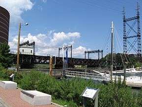
- Norwalk River Railroad Bridge[21] This bridge was built in 1896 as part of the New York, New Haven & Hartford Railroad's massive re-building of its New York to New Haven main line.
- South Main and Washington Streets Historic District[22] The district encompasses 35 buildings and two other structures (including the South Norwalk Railroad Bridge).
- United States Post Office–South Norwalk Main[23] Also known as Norwalk Main Post Office 16 Washington St. South Norwalk, CT
Emergency services
The Norwalk Police Department[24] is located at 1 Monroe St. near the heart of SoNo. The Norwalk Fire Department currently operates two Fire Stations in or near South Norwalk:[25]
- Station Two- Headquarters, 121 Connecticut Ave
- Station Five, 23 Meadow St.
See also
- South Norwalk (Metro-North station)
- South Norwalk Railroad Bridge
- St. Ladislaus Church (South Norwalk, Connecticut)
- List of mayors of Norwalk, Connecticut
- Connecticut Wildcats
- List of Carnegie libraries in Connecticut
- Washington Village
- Norwalk Harbor
Images
- Present Day
 Corner of Marshall and North Water Streets
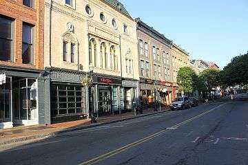 Washington Street facing west
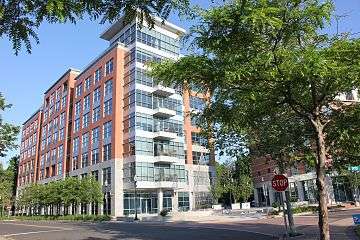 Maritime Condo Building
 Mural outside Donovan's Restaurant
 South Norwalk Train Station
 Switch Tower Museum
- Historical
 South Main Street 1919
 South Main Street 1887
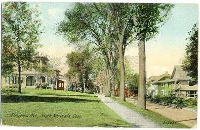 Elmwood Avenue 1912
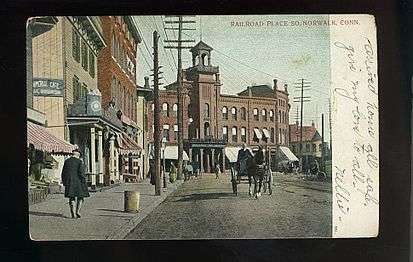 Railroad Place 1909
 First United Methodist Church, West Avenue, 1922
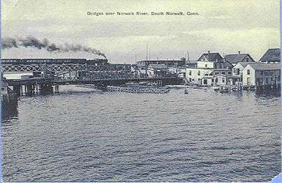 Norwalk River Bridge circa 1914
Development projects
- Ironworks SoNo
- District 95/7
References
- ↑ "SPECIAL TAXING DISTRICTS". OLR Research Report. Rute Pinho, Associate Analyst. Retrieved 9 February 2017.
- ↑ "TAXING DISTRICTS". City of Norwalk. Government Websites by CivicPlus®. Retrieved 9 February 2017.
- ↑ The Free Dictionary: SoNo http://acronyms.thefreedictionary.com/South+Norwalk,+Connecticut
- ↑ Keeping the "real South Norwalk alive", The Norwalk Advocate, By Brian Lockhart, Staff Writer http://jemann.com/realsono.html
- ↑ CT Dining and Events Guide http://www.ctdiningandeventsguide.com/towns/fairfield_county/historicsono.php
- ↑ 2 N Main St Norwalk, Connecticut Street View - Aug 2014 Google maps https://www.google.com/maps/@41.0990733,-73.4188233,3a,75y,114.7h,64.2t/data=!3m6!1e1!3m4!1sd18quysVvK5OZdm-p44vdQ!2e0!7i13312!8i6656?hl=en
- ↑ Norwalk Tax District Map http://www.norwalkct.org/DocumentCenter/View/4745
- ↑ Plan of Norwalk, Plan of South Norwalk. Fairfield County, Connecticut. Beers, Ellis, & Soule. 1867. http://www.davidrumsey.com/luna/servlet/s/yx48f4
- ↑ HISTORIC SOUTH NORWALK http://www.norwalkct.org/documentcenter/view/686
- ↑ Norwalk after two hundred & fifty years...etc. (p. 302-303) https://archive.org/stream/norwalkaftertwoh00weed#page/302/mode/2up
- ↑ A History of New England...etc. (p. 300)https://books.google.com/books?id=8sRWAAAAMAAJ&lpg=PA300&ots=5RZwkszZIK&dq=South%20Norwalk%20Original%20Settlement&pg=PA300#v=onepage&q=South%20Norwalk%20Original%20Settlement&f=false
- ↑ Norwalk after two hundred & fifty years...etc. (p. 380) https://archive.org/stream/norwalkaftertwoh00weed#page/380/mode/2up
- ↑ Charter of the City, Pub ... 1898 https://books.google.com/books?id=FFhDAAAAYAAJ&printsec=frontcover&dq=City+of+South+Norwalk+Charter&hl=en&sa=X&ved=0CDEQ6AEwAGoVChMImd7gn9StxwIVxD4-Ch2TiQTK#v=onepage&q&f=false
- ↑ Grant, Lisa Wilson. "Norwalk". Google Books. Arcadia Publishing. Retrieved 1 February 2017.
- ↑ The Second Taxing District By Isabel Bullen http://discovernorwalk.com/historic-sono/the-second-taxing-district/
- ↑ Meriden Morning Record - Apr 9, 1903, Governor's Veto https://news.google.com/newspapers?nid=2513&dat=19030409&id=53VHAAAAIBAJ&sjid=mv4MAAAAIBAJ&pg=1158,3910625&hl=en
- ↑ Beth Israel Synagogue (added 1991 - - #91001684) Also known as Canaan Institutional Baptist Church http://www.nationalregisterofhistoricplaces.com/ct/fairfield/state.html
- ↑ Haviland and Elizabeth Streets: Hanford Place Historic District(added 1988 - - #88000664) http://www.nationalregisterofhistoricplaces.com/ct/fairfield/state3.html
- ↑ Norwalk City Hall (added 1995 - #95000282) http://www.nationalregisterofhistoricplaces.com/ct/fairfield/state4.html
- ↑ http://norwalkhistoricalsociety.org/about/visit-us/
- ↑ Norwalk River Railroad Bridge (added 1987 - #87000844) Also known as Norwalk River Bridge http://www.nationalregisterofhistoricplaces.com/ct/fairfield/state4.html
- ↑ South Main and Washington Streets Historic District (Boundary Increase) (added 1985 - Fairfield County - #85003505)http://www.nationalregisterofhistoricplaces.com/ct/fairfield/districts.html
- ↑ United States Post Office–South Norwalk Main (added 1986 - - #86000126) http://www.nationalregisterofhistoricplaces.com/ct/fairfield/state6.html
- ↑ Police Department http://www.norwalkct.org/index.aspx?nid=139
- ↑ Norwalk Fire Department Stations http://www.norwalkct.org/index.aspx?NID=399
External links
- Facebook Sono Page
- Sono Dining, Shopping, and Entertainment [note: Veterans Memorial Park is in East Norwalk]
- Sono Arts Celebration website
- Sono Switch Tower Museum
- CNN Travel feature: "Say yes to Sono"
- Second Taxing District
- South Norwalk Electric and Water
- St. Joseph Church 85 S Main St Norwalk
Places adjacent to South Norwalk | |||||||||||||||
|---|---|---|---|---|---|---|---|---|---|---|---|---|---|---|---|
| |||||||||||||||
Municipalities and communities of Fairfield County, Connecticut, United States | ||
|---|---|---|
| Cities | 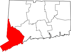 | |
| Towns | ||
| Borough | ||
| CDPs | ||
| Other communities | ||
| Ghost town | ||