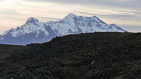
Solimana (volcano)
| Solimana | |
|---|---|
 | |
| Highest point | |
| Elevation | 6,093 m (19,990 ft) |
| Coordinates | 15°24′36″S 72°53′35″W / 15.41000°S 72.89306°WCoordinates: 15°24′36″S 72°53′35″W / 15.41000°S 72.89306°W |
| Geography | |
 Solimana Peru | |
| Location | Arequipa Region |
| Parent range | Andes |
Solimana[1][2] is a volcanic massif in the Andes of Peru, about 6,093 metres (19,990 ft) high.[3] It is situated in the Arequipa Region, Condesuyos Province, in the districts of Chichas and Salamanca, and in the La Unión Province, in the districts of Cotahuasi and Toro.[4] Solimana lies southeast of the volcanoes Sara Sara and Auquihuato and northwest of Coropuna volcano.
References
- ↑ Peru 1:100 000, Cotahuasi (31-q). IGN (Instituto Geográfico Nacional - Perú).
- ↑ Ziółkowski, Mariusz (2008). "Coropuna y Solimana: los oráculos de Condesuyos". In Curatola, Marco; Ziółkowski, Mariusz. Adivinación y oráculos en el mundo andino antiguo. Lima: Fondo Editorial PUCP – IFEA. pp. 121–159. ISBN 9789972428463.
- ↑ Biggar, John (2005). The Andes: A Guide for Climbers. Andes. p. 153. ISBN 9780953608720.
- ↑ escale.minedu.gob.pe - UGEL Map of the Condesuyos Province (Arequipa Region)
This article is issued from
Wikipedia.
The text is licensed under Creative Commons - Attribution - Sharealike.
Additional terms may apply for the media files.