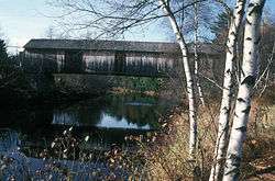
Slate Covered Bridge
|
Slate Covered Bridge | |
 The 1862 bridge, in 1970 | |
  | |
| Location | Off NH 10, Westport, New Hampshire |
|---|---|
| Coordinates | 42°50′50″N 72°20′25″W / 42.84722°N 72.34028°WCoordinates: 42°50′50″N 72°20′25″W / 42.84722°N 72.34028°W |
| Area | less than one acre |
| Built | 1862 |
| Architectural style | Town lattice truss |
| NRHP Reference # | 78000212[1] |
| Added to NRHP | November 14, 1978 |
The Slate Covered Bridge is a wooden covered bridge which carries the Westport Village Road (formerly New Hampshire Route 10) over the Ashuelot River in Westport, a village of Swanzey, New Hampshire. The bridge was built in 2001, as a replacement for an 1862 bridge that was destroyed by arson fire in 1993.[2]
The 1862 bridge was a single span Town lattice truss, with a span of 122 feet (37 m) and a roadway width of 17 feet (5.2 m). Its name derives from a family that lived nearby at the time of its construction. It rested on abutments of split granite, and was covered with a tin roof. Its sides were fully sheathed, and it had numerous repairs and parts replaced.[3] It was listed on the National Register of Historic Places in 1978.[1]
See also
- National Register of Historic Places listings in Cheshire County, New Hampshire
- List of bridges on the National Register of Historic Places in New Hampshire
- List of New Hampshire covered bridges
References
- 1 2 National Park Service (2009-03-13). "National Register Information System". National Register of Historic Places. National Park Service.
- ↑ "Winter 2002 Newsletter". National Society for the Preservation of Covered Bridges. Retrieved 2014-04-10.
- ↑ "NRHP nomination for Slate Covered Bridge" (PDF). National Park Service. Retrieved 2014-04-10.
External links
- Slate Bridge, NH Division of Historical Resources
This article is issued from
Wikipedia.
The text is licensed under Creative Commons - Attribution - Sharealike.
Additional terms may apply for the media files.
