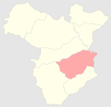
Shushinsky Uyezd
| Shushinsky Uyezd (in English) | ||
|---|---|---|
| ||
 | ||
| ||
| Established | 1840 | |
| Abolished | 1921 | |
| Political status | Uyezd | |
| Region | Caucasus | |
| Area | 4,315.6 verst² | |
| Population (1897 census) | ||
| • Total | 138771 | |
| • Density | 32.2 inhab. / verst² | |
| Government | ||
Shushinsky Uyezd (Russian: Шушинский уезд), was one of the uyezds (administrative units) of Elisabethpol Governorate of the Russian Empire, and then of Ganja Governorate of Azerbaijan Democratic Republic with its center in Shusha in 1840–1921.[1]
Geography
Elisabethpol Governorate consisted of Yelizavetpolsky, Nukhinsky, Shushinsky, Zangezursky, Kazakhsky, Areshsky, Dzhebrailsky, and Dzhevanshirsky Uyezds.[2] Shusha uyezd was located in the southeastern part of Elisabethpol Governorate bordering its Javanshir Uyezd on the north, Jabrayil Uyezd on the south, Zangezur Uyezd on the west and Baku Governorate on the east. The area covered 4,316 square verst, or 4,911 km (3,052 mi). The uyezd was normally divided into the mountainous, submountanous and lowland parts. The mountains covered the southwestern part of the uyezd and were part of the Lesser Caucasus range, reaching as high as 8,988 ft (2,740 m) above sea level. The gorges and valleys towards the northeast made up the submountainous areas of the uyezd. The lowland part of the uyezd is rich with rivers. Khachinchay river separates Shusha uyezd from Javanshir uyezd.[3]
History
The territories of Shusha uyezd were part of Karabakh Khanate until 1813, when the area was incorporated into Russian Empire. Russian rule was officially established in 1823. On April 10, 1840 Shusha uyezd was established as a separate administrative unit within Caspian Oblast of the empire with Shusha as its capital. From 1846 on, it was an administrative unit of Shemakha Governorate (later renamed to Baku Governorate in 1859). In 1868, the uyezd was incorporated into Elisabethpol Governorate.[3] In 1873, the territories of Javanshir and Jabrayil of Shusha uyezd were established as separate administrative uyezds.[4] After the Russian Empire ceased to exist and Azerbaijan Democratic Republic was founded in 1918, Shushinsky, Dzhevanshirsky, Dzhebrailsky, and Zangezursky Uyezds became a part of Azerbaijani-Armenian territorial disputes. In August 1919, as a result of a provisional accord Shusha, Javanshir, Jabrayil were placed under Azerbaijani Governor-Generalship of Khosrov bey Sultanov by the British command.[5][6]
Population
According to census held in 1897, the population of the uyezd was 138,771, of which 73,953 were Armenians and 62,868 were Azerbaijanis.[7] The population was engaged primarily in agriculture and farming in the mountainous areas, gardening, sericulture and cattlebreeding in submountainous areas. The lowland area was used for growing cotton, which produced 20 thousand pounds of cotton per year. Vineyards covered as much as 4,494 desyatinas of land, producing 106,860 lbs of grape. Nearly 10,000 lbs of silk pods were being collected per annum. Cattlebreeding which played an important role in the regional economy accounted 38,888 of cattle, 10,918 buffalos, 133,648 sheep, 3,052 goats, 8,016 horses, 4,052 donkeys, 1,052 mules, 340 camels, 4,052 pigs. [3]
References
- ↑ Chisholm, Hugh (1910). The Encyclopædia Britannica: a dictionary of arts, sciences, literature and general information. Volume 9. Leiden, the Netherlands: The Encyclopædia Britannica Company. p. 280. ISBN 978-90-04-17901-1. Retrieved 2011-08-02.
- ↑ "Административно-территориальные реформы на Кавказе в середине и во второй половине ХIХ века" [Administrative-territorial reforms in Caucasus in middle and second half of 19th century]. Retrieved 2011-08-02.
- 1 2 3 "Брокгауз-Ефрон и Большая Советская Энциклопедия. Шуша" [Brockhaus and Efron Encyclopedia. Shusha]. Retrieved 2011-08-02.
- ↑ Milman, Aron Shmulyevich (1966). Политический строй Азербайджана в XIX-начале XX веков: административный аппарат и суд, формы и методы колониального управления. USA: Azerbaijan State Publishing. Original from Pennsylvania State University. p. 114.
- ↑ Hille, Charlotte (2010). State Building and Conflict Resolution in the Caucasus. Leiden, the Netherlands: Koninklijke Brill NV. pp. 165–166. ISBN 978-90-04-17901-1. Retrieved 2011-08-02.
- ↑ "Общие сведения об административно-территориальном делении" [Presidential library. General data about administrative-territorial divisions] (PDF). Retrieved 2011-08-02.
- ↑ "Первая всеобщая перепись населения Российской Империи 1897 г. Распределение населения по родному языку и уездам Российской Империи кроме губерний Европейской России" [First All Russian Imperial Census of 1897. Population split according to languages spoken; uyezds of Russian empire except for governorates in European part of empire]. Retrieved 2011-08-02.
