Shelly Island

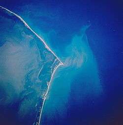
Shelly Island is a sandy island which began forming around April 2017, as a sandbank in the Outer Banks of North Carolina. Located off the tip of Cape Point in Buxton, North Carolina, the crescent-shaped island measures around one mile long and more than 500 ft (150 m) wide. It was nicknamed Shelly Island by locals because of the vast quantities of shells that are found on the shore.
Geography
The island sits a few hundred feet away from Hatteras Island, with water at depth of no more than 5 ft (1.5 m).[1] The surrounding area is referred to as the Graveyard of the Atlantic.[2][3] Small landmasses frequently appear and vanish in this area, but Shelly Island is notable for its size and the speed with which it formed.[4] As long as the island remains detached, it falls under the jurisdiction of Dare County, North Carolina. If it grows enough to merge into Hatteras Island, it will potentially come under federal jurisdiction and become part of Cape Hatteras National Seashore.[1] The island will likely not last a full year as a separate landform.[4]
References
- 1 2 Price, Mark. "So who owns that new island off North Carolina? It's likely not who you think", Charlotte Observer. July 7, 2017.
- ↑ Janice Williams (30 June 2017). "How Are Islands Formed? New Mysterious Land Mass Appears off North Carolina". Newsweek. Retrieved 2 July 2017.
- ↑ http://www.cbsnews.com/news/shelly-island-new-beach-north-carolina-outer-banks/
- 1 2 Welch, Craig. "New Island Appears Off Coast of North Carolina in Outer Banks", National Geographic. June 27, 2017.