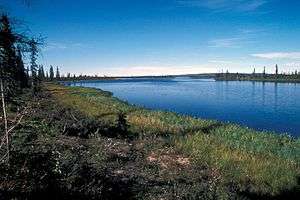
Selawik River
| Selawik River | |
 Flowing through the Selawik National Wildlife Refuge | |
| Country | United States |
|---|---|
| State | Alaska |
| Districts | Yukon–Koyukuk Census Area, Northwest Arctic Borough |
| Source | Purcell Mountains |
| - location | Yukon–Koyukuk Census Area |
| - elevation | 1,825 ft (556 m) [1] |
| - coordinates | 66°16′52″N 156°50′51″W / 66.28111°N 156.84750°W [2] |
| Mouth | Selawik Lake |
| - location | 8 miles (13 km) north of Selawik, Northwest Arctic Borough |
| - elevation | 0 ft (0 m) [2] |
| - coordinates | 66°36′06″N 160°19′47″W / 66.60167°N 160.32972°WCoordinates: 66°36′06″N 160°19′47″W / 66.60167°N 160.32972°W [2] |
| Length | 140 mi (225 km) [3] |
 Location of the mouth of the Selawik River in Alaska | |
The Selawik River is a stream, 140 miles (230 km) long, in the northwestern part of the U.S. state of Alaska.[3] Originating in the Purcell Mountains near the Zane Hills, it flows generally west through the Selawik National Wildlife Refuge to Selawik Lake, which empties into the Kotzebue Sound in the Chukchi Sea.[4] The river is approximately at the latitude of the Arctic Circle.[4]
The village of Selawik is along the river near its mouth.[4] The river is used for subsistence fishing by residents and for rafting and sport fishing by tourists.
See also
References
- ↑ Derived by entering source coordinates in Google Earth.
- 1 2 3 "Selawik River". Geographic Names Information System. United States Geological Survey. March 23, 2001. Retrieved September 17, 2013.
- 1 2 Orth, Donald J.; United States Geological Survey (1971) [1967]. Dictionary of Alaska Place Names: Geological Survey Professional Paper 567 (PDF). University of Alaska Fairbanks. United States Government Printing Office. p. 852. Retrieved September 17, 2013.
- 1 2 3 Alaska Atlas & Gazetteer (7th ed.). Yarmouth, Maine: DeLorme. 2010. p. 133. ISBN 978-0-89933-289-5.
This article is issued from
Wikipedia.
The text is licensed under Creative Commons - Attribution - Sharealike.
Additional terms may apply for the media files.