Schede (river)
| Schede | |
|---|---|
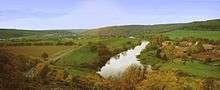 The Weser near Hilwartshausen at its confluence with the Schede (lower left) | |
| Location | near Hann. Münden; Göttingen, Lower Saxony (Germany) |
| Basin features | |
| Main source |
At the eastern edge of the Bramwald forest near Bühren ca. 300 m above sea level (NHN) 51°28′46″N 9°40′03″E / 51.47944°N 9.66750°ECoordinates: 51°28′46″N 9°40′03″E / 51.47944°N 9.66750°E |
| River mouth |
Opposite Hilwartshausen into the Weser ca. 110 m above sea level (NHN) 51°26′58″N 9°38′36″E / 51.44944°N 9.64333°E |
| River system | Weser |
| Tributaries |
|
| Physical characteristics | |
| Length | 13.0 km [1] |
The Schede in the south Lower Saxon county of Göttingen is a 13.0-kilometre-long, right and eastern tributary of the River Weser in Germany.
See also
References
- ↑ Niedersächsisches Landesverwaltungsamt: Topographische Karte 1:50000 – Normalausgabe – L4524 Göttingen und L4522 Hannoversch Münden, Hannover 1996, ISBN 3-89435-542-5
This article is issued from
Wikipedia.
The text is licensed under Creative Commons - Attribution - Sharealike.
Additional terms may apply for the media files.