Scharmützelsee (Amt)
Scharmützelsee is an Amt ("municipal federation") in the district of Oder-Spree, in Brandenburg, Germany. Its seat is in Bad Saarow.
The Amt Scharmützelsee consists of the following municipalities:
- Bad Saarow
- Diensdorf-Radlow
- Langewahl
- Reichenwalde
- Wendisch Rietz
Demography
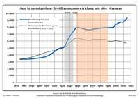
Development of Population since 1875 within the Current Boundaries (Blue Line: Population; Dotted Line: Comparison to Population Development of Brandenburg state; Grey Background: Time of Nazi rule; Red Background: Time of Communist rule)
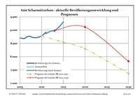
Recent Population Development (Blue Line) and Forecasts
Amt Scharmützelsee:
Population development within the current boundaries (2013)[1]
| Year |
Population |
|---|
| 1875 | 3 365 |
| 1890 | 3 422 |
| 1910 | 3 800 |
| 1925 | 4 855 |
| 1933 | 5 231 |
| 1939 | 6 521 |
| 1946 | 7 579 |
| 1950 | 7 915 |
| 1964 | 7 593 |
| 1971 | 7 691 |
|
|
| Year |
Population |
|---|
| 1981 | 7 840 |
| 1985 | 7 896 |
| 1989 | 7 913 |
| 1990 | 7 938 |
| 1991 | 7 892 |
| 1992 | 7 864 |
| 1993 | 7 914 |
| 1994 | 7 942 |
| 1995 | 7 889 |
| 1996 | 7 935 |
|
|
| Year |
Population |
|---|
| 1997 | 7 980 |
| 1998 | 8 064 |
| 1999 | 8 297 |
| 2000 | 8 368 |
| 2001 | 8 458 |
| 2002 | 8 414 |
| 2003 | 8 514 |
| 2004 | 8 646 |
| 2005 | 8 699 |
| 2006 | 8 685 |
|
|
| Year |
Population |
|---|
| 2007 | 8 770 |
| 2008 | 8 722 |
| 2009 | 8 722 |
| 2010 | 8 785 |
| 2011 | 8 870 |
| 2012 | 8 959 |
| 2013 | 8 980 |
| 2014 | 9 112 |
| 2015 | 9 311 |
|
|
Coordinates: 52°16′59″N 14°04′00″E / 52.28306°N 14.06667°E / 52.28306; 14.06667
References
 Development of Population since 1875 within the Current Boundaries (Blue Line: Population; Dotted Line: Comparison to Population Development of Brandenburg state; Grey Background: Time of Nazi rule; Red Background: Time of Communist rule)
 Recent Population Development (Blue Line) and Forecasts