Saraburi Province
| Saraburi สระบุรี | ||
|---|---|---|
| Province | ||
|
| ||
| ||
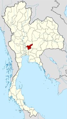
 Map of Thailand highlighting Saraburi Province | ||
| Country | Thailand | |
| Capital | Saraburi | |
| Government | ||
| • Governor | Bundit Theveethivarak (since October 2016) | |
| Area | ||
| • Total | 3,577 km2 (1,381 sq mi) | |
| Area rank | Ranked 56th | |
| Population (2014) | ||
| • Total | 633,460[1] | |
| • Rank | Ranked 42nd | |
| • Density rank | Ranked 17th | |
| Time zone | ICT (UTC+7) | |
| ISO 3166 code | TH-19 | |
Saraburi (Thai: สระบุรี) is one of the central provinces (changwat) of Thailand. Neighboring provinces are (from north clockwise) Lopburi, Nakhon Ratchasima, Nakhon Nayok, Pathum Thani, and Ayutthaya. Saraburi has been an important town since ancient times. It is believed to have been constructed in the year 1548 during the reign of King Maha Chakkraphat of Ayutthaya as a centre for recruiting troops.
Geography

Saraburi is on the east side of the Chao Phraya River valley. The eastern part of the province is covered by high plains and plateaus, while the western part is mostly low flat plains.
Two national parks are in the province. Namtok Chet Sao Noi protects 28 km² around a scenic waterfall. Phra Puttachai protects the Khao Sam Lan Forest, which consists of hilly landscape and is the source to several rivers and waterfalls. The highest elevation is the Khao Khrok at 329 m. The 44.57 km² were declared a national park in 1981.
The town, as a gateway to the northeastern region, is 108 km from Bangkok. It occupies an area of 3,577 square kilometres.
History
Saraburi has been an important city since ancient times. It is assumed to have been established approximately in 1549 during the reign of King Maha Chakkraphat of the Kingdom of Ayutthaya. It is assumed that the king had ordered to combine some parts of Lopburi and Nakhon Nayok together and set up Saraburi Province with the aim of mobilizing citizens during times of war. Therefore, from the Ayutthaya period, the story of Saraburi has usually related to battles and wars. As for the origin of the word "Saraburi", it is assumed that due to its location near a swamp called "Bueng Nong Ngong", when the town was established a combination of "Sa" ("swamp") and "buri" ("town") was suggested and the town was named "Saraburi".

Climate
Saraburi has a Tropical Savanna Climate, Aw (Climate Classification system of Koppen) The climate is arid with little rain in winter, relatively high temperatures in summer, cool in winter, and rain from May to October, about 70-90 days
The average annual temperature is 28-29 degrees Celsius. Maximum temperatures average 33-34 degrees Celsius and minimum temperature averages 23-24 degrees Celsius. April is the hottest month of the year, while winters are cool in January.
Education
There are 366 schools. There are a total of 125,255 students at all levels.
Economic
Economic conditions of Saraburi in 2007 found that the population has an average income per capita 214,537 baht per year, making it tenth highest in the country, second in the central provinces. Annual GDP was 129,275 million baht.
Religion and culture
In 2007, Saraburi's population was 89.34 percent Buddhist, 597,138 persons. There are 499 temples. There are total of 3,443 monks and 274 neophytes. Muslims number 953 (0.32 percent). There are five Christian churches.
Forest
Saraburi Province has 2,235,304 acres of forest, including 460,522.25 acres of national forest (20.6%).
Air quality
Saraburi has poor air quality resulting from cement production, chiefly stone crushing, at 79 factories, more than 70 percent in the Na Pra Lan District.
Places
The most important Buddhist temple is Wat Phra Phutthabat, built under King Songtham in the 17th century, is located around a Buddha footprint. It is the most popular pilgrimage site in central Thailand.
Close to that temple, Wat Tham Krabok is famous for its drug detoxification. Additionally it was the last of the Hmong refugee camps in Thailand.
Symbols
The provincial seal shows the temple Wat Phra Buddha Baat. In the 17th century a hunter found a puddle of water which looked like a large footprint. It was declared a footprint of Buddha, and a temple was built around it. Phra Phutthabat means footprint of Buddha.
The provincial tree is Lagerstroemia floribunda and the provincial flower is the yellow cotton tree (Cochlospermum regium).
Administrative divisions

The province is divided into 13 districts (amphoe). The districts are further subdivided into 111 communes (tambon) and 965 villages (muban).
Tourism
Sights
Phu Khae Botanical Garden (สวนพฤกษศาสตร์ภาคกลาง (พุแค): Established in 1941 as the first Royal Forest Department Botanical garden, it sprawls over an area of 300 ha of which 100 ha is natural vegetation and forest. It also features a literary garden, comprising 35 species of plants which are mentioned in Thai literature. It also contains a medicinal garden.[2]
Sunflower Fields (ทุ่งทานตะวัน)[3] are found between Lopburi and Saraburi along the Phatthana Nikhom – Wang Muang route. From November to December, the yellow sunflower fields along the road attract many people.
Local products
Food and Dairy Products: Products from the Dairy Farming Promotion Organisation of Thailand, Muak Lek Dairy Cooperatives, and private organizations are sold, including sweetened beef, salted beef, curry puffs, vegetables and seasonal fruits like Nong Saeng mangoes, oranges, custard apples, pomegranates, dragon fruit, and grapes.
The area is also home to the Caroline cheese factory, one of Thailand's oldest family-owned cheese producers.
Other famous local food products are "Herbal Chinese Pork Sausage with Iodine" (Kun Chiang), "Sweet Dried Pork" (Mu Sawan), "Pounded Pork" (Mu Thup) and "Pork Stewed in Gravy" (Mu Phalo) and "Krayasat" (cereals and nuts in honey caramel).
Local Hand-woven Fabrics are Tin Chok, silk, and Mudmee textiles of the Thai Yuan people.
Culture
Festivals
The National Dairy Cow Festival (งานโคนมแห่งชาติ) is organized in the Muak Lek District in January every year. Princess Maha Chakri Sirindhorn is the chairperson for the opening ceremony. It is the biggest event in Thailand for professional dairy farmers.
The Phra Phutthabat Homage Paying Fair (งานนมัสการรอยพระพุทธบาท) is held twice a year: starting on the first day of the waxing moon and continuing for 15 days until the full moon day in the third lunar month; and from the eighth day of the waxing moon, continuing for eight days until the full moon day in the fourth lunar month.
The Kam Fa Festival (ประเพณีกำฟ้า) is held on the second day of the waxing moon in the third lunar month. The eve of the festival features various forms of folk entertainment and activities including cockfighting and toasting sticky rice in bamboo. The Kam Fa Festival occurs on the third day of the waxing moon in the third lunar month. People perform merit making and attend sermons. The festival takes place annually at Phai Lio Sub-district, Don Phut District.
The Wat Sung Songkran Festival and Sao Nang Takhian Bathing (ประเพณีสงกรานต์สรงน้ำเสานางตะเคียนวัดสูง) is held annually on 23 April in front of Wat Sung's ordination hall, Sao Hai District. People perform merit making ceremonies and pour water onto elders and onto the Nang Takhian pillar.
Hae Phra Khiao Kaeo (ประเพณีแห่พระเขี้ยวแก้ว): Buddhists believe that Phra Khiao Kaeo was the tooth of the Lord Buddha. A festival is held on the first day of the waxing moon in the fourth lunar month. The people of Amphoe Phra Phutthabat take the tooth from Wat Phra Phutthabat Ratchaworamahawihan Museum and carry it in a procession around the town. They believe that if the procession is held, they will live in wealth and happiness. It is an annual tradition of Phra Phutthabat District.
The Chaopho Khao Tok Fair or Chaopho Khao Tok Procession (ประเพณีเจ้าพ่อเขาตก หรือ งานแห่เจ้าพ่อเขาตก) is held at Wat Phra Phutthabat Ratchaworamahawihan, Phra Phutthabat District, and is an annual fair. The event features supernatural power performances of Chaopho Khao Tok such as fire walking. There is also the Lo Ko dragon parade and Chinese opera performances. Mainly Chinese people, especially the followers of Chaopho Khao Tok, come from all over the country to celebrate this festival. The event begins on the first day of the waxing moon in the fourth lunar month, and continues for four days.
The Tak Bat Dok Mai Ceremony (ประเพณีตักบาตรดอกไม้) is considered a significant tradition of Phra Phutthabat District. This merit-making ceremony is held to coincide with the start of the annual three-month Buddhist Lent on the first day of the waning moon of the eighth lunar month. During the ceremony, people offer alms to monks and candles to Wat Phra Phutthabat, early in the morning. In the afternoon, they offer flowers to the monks at Wat Phra Phutthabat Ratchaworamahawihan, Khun Khlon Sub-district, Phra Phutthabat District. They go to collect a kind of flower similar to Krachai (Rotunda) or turmeric with yellow or white flowers called "The Flower of Buddhist Lent". This herb-like flower is found on the hillside only during the Buddhist Lent period and only in Saraburi. While the monks are walking up the staircase to take the flowers to pay homage to the Lord Buddha's footprint, people wait along the steps with bowls of clean water in which are floated bullet wood flowers. They pour the water onto the feet of the monks as a means of washing away their sins. The Flower of Buddhist Lent was listed as a new species of plant in the world in the International Flowers Fair in July 2001 at Jurong Bird Park in Singapore.
References
- ↑ "Population of the Kingdom" (PDF). Department of Provincial Affairs (DOPA) Thailand (in Thai). 2014-12-31. Retrieved 19 Mar 2015.
- ↑ http://www.dnp.go.th/botany/botany_eng/garden.html Archived April 9, 2009, at the Wayback Machine.
- ↑ Sunflower Fields (ทุ่งทานตะวัน).
External links
 Saraburi travel guide from Wikivoyage
- Provincial page, Tourist Authority of Thailand
- Khao Yai National Park
- Saraburi history in Thai language Archived April 9, 2008, at the Wayback Machine.
| Wikimedia Commons has media related to Saraburi. |
Coordinates: 14°31′42″N 100°54′35″E / 14.52833°N 100.90972°E

