Sankt Egidien
| Sankt Egidien | |
|---|---|
 Sankt Egidien | |
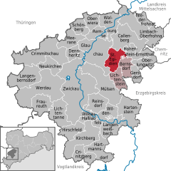
Location of Sankt Egidien within Zwickau district 
 | |
| Coordinates: 50°47′6″N 12°37′12″E / 50.78500°N 12.62000°ECoordinates: 50°47′6″N 12°37′12″E / 50.78500°N 12.62000°E | |
| Country | Germany |
| State | Saxony |
| District | Zwickau |
| Municipal assoc. | Rund um den Auersberg |
| Government | |
| • Mayor | Uwe Redlich |
| Area | |
| • Total | 21.24 km2 (8.20 sq mi) |
| Elevation | 261 m (856 ft) |
| Population (2015-12-31)[1] | |
| • Total | 3,302 |
| • Density | 160/km2 (400/sq mi) |
| Time zone | CET/CEST (UTC+1/+2) |
| Postal codes | 09356 |
| Dialling codes | 037204 |
| Vehicle registration | Z |
| Website | www.sankt-egidien.de |
Sankt Egidien (Saint Egidien) is a municipality in the district of Zwickau in Saxony in Germany.
History
The town was named after Saint Giles, allegedly for missionary work done by him or his disciples to the Goths.
References
This article is issued from
Wikipedia.
The text is licensed under Creative Commons - Attribution - Sharealike.
Additional terms may apply for the media files.