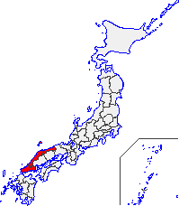
San'in region
| San'in region 山陰地方 | |
|---|---|
| Region | |
|
Map of the San'in Region | |
| Area | |
| • Total | 11,680.73 km2 (4,509.96 sq mi) |
| Population (June 1, 2009) | |
| • Total | 1,416,011 |
| • Density | 120/km2 (310/sq mi) |
| Time zone | JST (UTC+9) |
The San'in Region (山陰地方 San'in Chihō) is an area in the southwest of Honshū, the main island of Japan. It consists of the northern part of the Chūgoku region, facing the Sea of Japan.[1]
Etymology
The name San'in in the Japanese language is formed from two kanji characters. The first, 山, "mountain", and the second, 陰 represents the "yin" of yin and yang. The name means the northern, shady side of the mountains in contrast to the yang "southern, sunny" San'yō region to the south.
History
Early history
The San'in region has numerous Paleolithic and Jōmon period (14,000 – 300 BC) remains, but its Yayoi period (300 BC – 250 AD) remains are the largest in Japan. The Mukibanda Yayoi remains in the low foothills of Mount Daisen[2] in the cities of Daisen and Yonago, Tottori Prefecture are the largest in Japan.[3] The site is still only partially excavated, but indicates that the San'in was a regional center of power in the period. The mythology of the Shinto religion is largely based in the Izumo area of the region,[4] and the Izumo-taisha, or Izumo Grand Shrine in Izumo, Shimane Prefecture, is one of the most ancient and important Shinto shrines in Japan.[5] The eastern part of Shimane Prefecture also had cultural and economic connections to the Asian mainland from an early period.[4]
San'indō
The San'in region corresponds to San'indō (山陰道), one of the gokishichidō, or five provinces and seven circuits established in the Asuka Period (538 – 710) under the Ritsuryo legal system.[6] San'indō refers not only to the ancient geographic region, but also the main road through the region that connected it to the capitol in Kyoto.[7] The San'in encompassed the pre-Meiji provincial areas of Tamba, Tango, Tajima, Inaba, Hōki, Izumo, Iwami and Oki.[8][9]
San'indō route
While the San'indō route was used for military logistics in numerous conflicts after the Asuka period, it more importantly served as a route for the transport of good to and from the region. The route reached its highest period of importance in the Edo period (1603 – 1867) when the Tokugawa shogunate formalized its route and shukuba post stations. The daimyō regional rulers used the San'indō for their sankin kotai mandatory journeys to Edo.
Modern usage
The San'in region now has no administrative authority. In modern Japanese usage it generally refers to the prefectures of Shimane, Tottori and northern area of Yamaguchi.[6] The northern areas of Hyōgo and Kyōto prefectures are sometimes included in the region as well.[10] Japan Route 9, the San'in Expressway, and the JR West San'in Main Line follow the historical route of the San'indō, and remnants of the shukuba, some well preserved, remain throughout the region.
Geography
The San'in Region has a long coastline along the Japan Sea that dramatically sweeps south to the Chūgoku Mountains along the length of the region. The area is primarily mountainous with few plains.[6] While the climate of the San'in region is not as harsh as that of the Hokuriku region to the north, winters are characterized by heavy snow and rainfall typical of areas on the Japan Sea.[9]
Economy
The San'in region is far from the industrial and cultural heartlands of Japan, and the region is consequently economically undeveloped compared to the other regions of Japan.[6] The landscape remains rural and unindustrialized, and the urban areas of the region are decentralized.[9] Tottori and Shimane are the least populated prefectures in Japan, and the population is aging at a rate faster than the rest of Japan. Cities in the region with a population of over 100,000 remain only the prefectural capitols of Tottori and Matsue, the more recently industrialized Yonago, and Izumo, a city formed from numerous smaller cities and villages after World War II. The agricultural output of the San'in region, however, remains very high. Its broad coastal and mountainous areas are protected as national, prefectural, and municipal parks, and these areas are now popular tourist destinations.
Transportation
The San'in region is connected by several JR West rail lines and some highways, but transportation is relatively undeveloped compared to other regions of Japan. Projects to connect the region to the wider highway network of Japan continue.[9]
See also
Notes
- ↑ Nussbaum, Louis-Frédéric. (2005). "San'in" in Japan Encyclopedia, p. 817, p. 817, at Google Books; Titsingh, Isaac. (1834). Annales des empereurs du japon, p. 65., p. 65, at Google Books
- ↑ "Mukibanda-iseki (妻木晩田遺跡)". Nihon Rekishi Chimei Taikei (日本歴史地名大系 (in Japanese). Tokyo: Shogakukan. 2012. Retrieved 2012-04-07.
- ↑ Muki-Banda Remains
- 1 2 "Tone-gawa". Nihon Kokugo Daijiten (日本国語大辞典) (in Japanese). Tokyo: Shogakukan. 2012. Retrieved 2012-02-28.
- ↑ "Kurayoshi Plain". Encyclopedia of Japan. Tokyo: Shogakukan. 2012. Retrieved 2012-04-12.
- 1 2 3 4 "San'in region". Encyclopedia of Japan. Tokyo: Shogakukan. 2012. Retrieved 2012-04-13.
- ↑ Titsingh, Isaac. (1834). Annales des empereurs du japon, p. 65., p. 65, at Google Books
- ↑ Titsingh, p. 65 n3., p. 65, at Google Books
- 1 2 3 4 "美保湾 (Miho-wan)". Nihon Daihyakka Zensho (Nipponika) (日本大百科全書(ニッポニカ) (in Japanese). Tokyo: Shogakukan. 2012. Retrieved 2012-04-15.
- ↑ "山陰地方 (San'in chihō)". Dijitaru daijisen (in Japanese). Tokyo: Shogakukan. 2012. Retrieved 2012-04-15.
References
- Nussbaum, Louis-Frédéric and Käthe Roth. (2005). Japan encyclopedia. Cambridge: Harvard University Press. ISBN 978-0-674-01753-5; OCLC 58053128
- Titsingh, Isaac. (1834). Nihon Odai Ichiran; ou, Annales des empereurs du Japon. Paris: Royal Asiatic Society, Oriental Translation Fund of Great Britain and Ireland. OCLC 5850691.

