Samut Prakan Province
| Samut Prakan สมุทรปราการ | ||
|---|---|---|
| Province | ||
 | ||
| ||
 Map of Thailand highlighting Samut Prakan Province | ||
| Country | Thailand | |
| Capital | Mueang Samut Prakan | |
| Government | ||
| • Governor | Chatchai Uthaiphan (since October 2016) | |
| Area | ||
| • Total | 1,004.1 km2 (387.7 sq mi) | |
| Area rank | Ranked 70th | |
| Population (2014) | ||
| • Total | 1,261,530[1] | |
| • Rank | Ranked 18th | |
| • Density rank | Ranked 3rd | |
| Time zone | ICT (UTC+7) | |
| ISO 3166 code | TH-11 | |
| Website |
www | |
Samut Prakan (Thai: สมุทรปราการ, pronounced [sāmùt prāːkāːn]) is one of the central provinces (changwat) of Thailand, established by the Act Establishing Changwat Samut Prakan, Changwat Nonthaburi, Changwat Samut Sakhon and Changwat Nakhon Nayok, Buddhist Era 2489 (1946), which came into force 9 March 1946.
It is part of the Bangkok Metropolitan Region. Neighbouring provinces are Bangkok, to the north and west, and Chachoengsao to the east.
Suvarnabhumi Airport is in the Bang Phli District of Samut Prakan Province.
History

The province was created during the Ayutthaya period, with its administrative centre at Prapadaeng. It was the sea port of Siam, and was secured with forts, town moats, and town walls. King Rama II started the building of the new centre at Samut Prakan in 1819, after his predecessor King Taksin had abandoned the town fortifications. Altogether six forts were built on both sides of the Chao Phraya River, and on an island in the river the pagoda, Phra Samut Chedi, was erected. These were involved in the Paknam incident of 13 July 1893, which ended the Franco-Siamese War with a French naval blockade of Bangkok. Of the original six forts only two still exist today, Phi Sua Samut and Phra Chulachomklao.
Etymology
In Thai the word samut is from Sanskrit, samudra, meaning "ocean" or "sea", and the word prakan is from Sanskrit, prākāra, meaning "fortress", "walls", or "stronghold".
Geography
- Pak Nam and Paknam redirect here
Samut Prakan is at the mouth of the Chao Phraya River on the Gulf of Thailand. Thus the province is also sometimes called Pak Nam (ปากน้ำ), the Thai word for the mouth of a river. The part of the province on the west side of the river consists mostly of rice paddies and shrimp farms as well as mangrove forests, while the eastern part is the urban centre, including industrial factories. It is part of the Bangkok metropolis. The urbanization on both sides of the provincial boundary is identical. The province has a coastline of approximately 47.2 kilometres.
Paknam incident

The Paknam Incident was a military engagement fought during the Franco-Siamese War in July 1893. While sailing off Paknam through Siam's Chao Phraya River, three French ships were fired on by a Siamese fort and force of gunboats. In the ensuing battle, France won and proceeded to blockade Bangkok which ended the war.
Conflict arose when the French Navy aviso Inconstant and the gunboat Comete arrived at Paknam and requested permission to cross the bar into the Chao Phraya. The French were on their way to Bangkok, further up the river, for negotiations. When the Siamese refused, the French commander, Rear Admiral Edgar Humann, disregarded the Siamese demands and instructions from his own government. Before the action Humann had been ordered not to cross the bar because the Siamese were well-prepared for battle. Siamese forces included seven 6-inch disappearing guns of the recently built Chulachomklao Fort. The Siamese also sunk several junks and a cargo ship in the river, creating only one narrow passage which the French had to traverse.
Five gunboats were anchored just beyond the sunken junks. They were the Siamese gunboats Makut Ratchakuman, Narubent Butri, Thun Kramon, Muratha Wisitsawat, and Han Hak. Two were modern warships while the others were older gunboats or converted river steamers. A sea mine field of sixteen explosives was also laid. Many Europeans served in the Siamese military at this time: a Dutch admiral commanded the fort, and the gunboats were commanded by a Danish Vice Admiral granted the royal title of Phraya Chonlayutyothin.

The French chose to cross the bar just after sunset on 13 July. Their objective was to fight their way past the Siamese defenses but only if fired upon. The weather was overcast and raining. By this time the Siamese were on high alert and at battle stations. The French ships were towed into action by the small mail steamer Jean Baptiste Say. At 18:15 the rain stopped and the Siamese gunners observed the French ships passing the nearby lighthouse. A few minutes later, the French were off Black Buoy when they entered the range of the fort. Siamese gunners were ordered to fire three warning shots, if they were ignored, then a fourth would signal their gunboats to begin firing.
At 18:30, the fort opened fire with two blank rounds but the French continued on, so a third, live, warning shot was fired and hit the water in front of the Jean Baptiste Say. When this warning was ignored a fourth shot was fired so the gunboats Makhut Ratchakuman and Muratha Wasitsawat opened up at 18:50. Inconstant returned fired on the fort while the Comete engaged the gunboats. A small Siamese boat filled with explosives was sent out to ram one of the French ships, but it missed its target. Combat lasted about twenty-five minutes.
Ultimately Rear Admiral Humann forced his way through the Siamese line, ramming and sinking one gunboat in the process. Another was hit by shell fire. Ten men were killed and twelve others wounded. The French suffered as well. While towing the warships past Paknam, the Jean Baptiste Say was hit several times by cannon fire. Her commander was forced to cut the tow line and ground his ship on Laem Lamphu Rai while the Inconstant and Comete proceeded onto Bangkok. Three Frenchmen were killed and two others were wounded. Comete received more hits than the Inconstant but the damage was not serious. The Siamese fort was not damaged.
The following morning, Jean Baptiste Say's crew was still on board their grounded vessel so the Siamese sent a boat and captured the steamer. They then attempted and failed to sink her. The prisoners were treated badly according to reports and put in a Bangkok prison. A day later, the French gunboat Forfait arrived at Paknam and sent a boat full of sailors to recapture the mail steamer but when they boarded, the Siamese occupants successfully repelled the attack. When Rear Admiral Humann arrived off Bangkok, he established a blockade, trained his guns on the royal palace and on 3 October 1893, a treaty was signed, ending the war.

Symbols
The provincial seal shows the temple Phra Samut Chedi, the most important site of Buddhist worship in the province.
The provincial tree is Thespesia populnea.
The provincial slogan is Marine Battle Fortresses, Chedi in the Water, Crocodile Farm, Exquisite Ancient City, Phra Pradaeng Songkran Festival, Tasty Dried Snakeskin Gourami, Rap Bua Festival, Industrial Estate
Administrative divisions

The province is divided into six districts (amphoe). The districts are further subdivided into 50 sub-districts (tambon) and 396 villages (muban). There is one city (thesaban nakhon), three towns (thesaban mueang) and 13 sub-district municipalities (thesaban tambon). For national elections the province is divided into three voting districts, one represented by three assemblymen and the other two each by two assemblymen.

Suvarnabhumi Airport
Suvarnabhumi Airport (rtgs: Suwannaphum; Thai pronunciation: [sù.wān.ná.pʰūːm][2]) (IATA: BKK, ICAO: VTBS), also known as (New) Bangkok International Airport, is one of two international airports serving Bangkok. The other one is Don Mueang International Airport.[3][4] Suvarnabhumi covers an area of 3,240 hectares (8,000 acres).
The airport is on what had formerly been known as Nong Nguhao (Cobra Swamp) in Racha Thewa in Bang Phli, Samut Prakan Province, about 25 kilometres (16 mi) east of downtown Bangkok. The terminal building was designed by Helmut Jahn of Murphy / Jahn Architects. It was constructed primarily by ITO JV. The airport has the world's tallest free-standing control tower (132.2 metres or 434 feet), and the world's fourth largest single-building airport terminal (563,000 square metres or 6,060,000 square feet).
Suvarnabhumi is the twentieth busiest airport in the world, sixth busiest airport in Asia, and the busiest in the country, having handled 53 million passengers in 2012,[5] and is also a major air cargo hub, with a total of 95 airlines. On social networks, Suvarnabhumi was the world's most popular site for taking Instagram photographs in 2012.[6]
The airport inherited the airport code, BKK, from Don Mueang after the older airport ceased international commercial flights. The modern Motorway 7 connects the airport, Bangkok, and the heavily industrial eastern seaboard of Thailand, where most export manufacturing takes place.
Ancient Siam

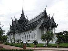
Ancient Siam (also known as Ancient City)(Thai: เมืองโบราณ, Mueang Boran) is a park constructed under the patronage of Lek Viriyaphant and spreading over 200 acres (0.81 km2) in the shape of Thailand.
The founder's original idea was to create a golf course with miniatures of Thailand's historically significant structures spread around the course. During his research he found most structures being severely damaged over time and decided instead of creating new miniatures to save the original structures when possible or re-creating them full size or scaled down.
Ancient Siam is dubbed as the world's largest outdoor museum. Situated close to the Crocodile Farm in Samut Prakan province, the 320-hectare city features 116 structures of Thailand's famous monuments and architectural attractions. The grounds of Ancient Siam correspond roughly to the shape of the Kingdom, with each of the monuments lying at their correct places geographically. Some of the buildings are life-size replicas of existing or former sites, while others are scaled down.
The replicas were constructed with the assistance of experts from the National Museum to ensure historical accuracy. Outstanding works include the former Grand Palace of Ayutthaya (destroyed in the Burmese invasion of 1767), Phimai Sanctuary in Nakhon Ratchasima, and Wat Khao Phra Viharn on the Cambodian border.
Bang Pu
.jpg)
In 1937 during an official trip to Chonburi, Field Marshal Plaek Pibulsongkhram took note of an area not far from Bangkok which was blessed with cool and breezy sea air and decided it was an ideal location for recreational purposes. Later, he had the land bought up. Bang Pu Seaside Resort was built and finished in 1939 for the Thai public. The resort closed down temporarily in the aftermath of the Japanese Imperial Army’s landing at Bang Pu and other provinces on the Gulf of Thailand, namely Prachuab Khirikhan, Chumpon, Surat Thani, Nakhon Srithammarat, Songkhla, Pattani and Kotabaru. Civil servants and the people in Samut Prakarn united and faced up to the Japanese troops, though no clashes were reported prior to a permission issued by the Thai Government for the Japanese Army to pass through Thailand to Burma. Nevertheless, it was evident that people from all walks of life had showed an unwavering unity and courage to protect the nation and its sovereignty.
After Japan pulled out of Thailand at the end of the war, and when peace was restored in 1947, the resort resumed its business. In 1948, it came under the jurisdiction of Quartermaster Department Royal Thai Army. Food and drinks were made available at the end of Sapan Sukta thereafter, and the Army’s convalescence facility for wounded soldiers was established. With the prevailing change in the domestic situation and the easing of hostility along the borders, the convalescence center was discontinued by the army, and Bang Pu was used exclusively as a recreational site.
At present, Bang Pu Seaside Resort offers a wide range of activities for the interested members of the public. Facilities include bungalows, shops, a restaurant, bird-feeding (a marquee symbol of Bang Pu) and Bangpu Nature Education Center. These make it a place of socio-economic and environmental value according to the sustainable development principle.
One of the most significant events to take place at Bang Pu was a royal visit by His Majesty King Bhumibol Adulyadej on July 4, 2013 to look at the surrounding mangrove eco system and for relaxation, thus creating the utmost happiness for the people in Samut Prakarn.
Bhumibol Bridge

The Bhumibol Bridge (Thai: สะพานภูมิพล), also known as the Industrial Ring Road Bridge (Thai: สะพานวงแหวนอุตสาหกรรม) is part of the 13 km long Industrial Ring Road connecting southern Bangkok with Samut Prakan Province. The bridge crosses the Chao Phraya River twice, with two striking cable-stayed spans of lengths of 702 m and 582 m supported by two diamond-shaped pylons 173 m and 164 m high. Where the two spans meet, another road rises to join them at a free-flowing interchange suspended 50 metres above the ground.
The bridge opened for traffic on 20 September 2006, before the official opening date of 5 December 2006. It is part of the Bangkok Industrial Ring Road, a royal scheme initiated by King Bhumibol Adulyadej that aims to solve traffic problems within Bangkok and surrounding areas, especially the industrial area around Khlong Toei Port, Southern Bangkok and Samut Prakan Province.
According to tradition, all the bridges over the Chao Phraya in Bangkok are named after a member of the Royal Family. In October 2009, it was announced that both bridges would be named after King Bhumibol Adulyadej,[7] with the northern bridge officially named "Bhumibol 1 Bridge" and the southern bridge "Bhumibol 2 Bridge".[8] The unofficial name "Mega Bridge" was also widely used.[9]
Basic structure of Bhumibol Bridge consists of two main parts that are: - Bhumibol Bridge 1 is the one across the northern part of Chao Praya River connecting Yannawa district, Bangkok and Songkranong district, Samut prakarn. It is a cable-stayed bridge with 7 lanes together with 2 high pillars. The structure is reinforced concrete 50m tall from the water level to let the cargo ship be able to travel by. - Bhumibol Bridge 2 is the one across the southern part of Chao Praya River connecting Songkranong district and Bangyhaprak district. The structure is almost the same as Bhumibol Bridge 1, with 7 lanes and 2 high pillars and built using reinforced concrete 50m tall from the water level to let the cargo ship be able to travel from Chao Praya River to Klongtoey pier.

Place
- Lak Mueang Shrine Phra Pradaeng
.jpg) Wat Song Tham
Wat Song Tham Samutprakarn Crocodile Farm and Zoo
References
- ↑ "Population of the Kingdom" (PDF). Department of Provincial Affairs (DOPA) Thailand (in Thai). 2014-12-31. Retrieved 19 Mar 2015.
- ↑ "How to pronounce Suvarnabhumi Airport". Forvo. Retrieved 5 March 2017.
- ↑ "Don Mueang to be city budget air hub". Bankgok Post. Retrieved 2 July 2013.
- ↑ "AirAsia to shift to Don Mueang". Retrieved 2 July 2013.
- ↑ 2011 Statistics Archived 27 November 2011 at the Wayback Machine.
- ↑ Bangkok Post, "Suvarnabhumi, Paragon top Instagram places list". Bangkok Post, 29 December 2012.
- ↑ "Breaking news, bangkok breaking news - The Nation". Nationmultimedia.com. Retrieved 2012-09-19.
- ↑ "Bhumibol Bridge in Samut Prakan สะพานภูมิพล - Samut Prakan (Paknam) จังหวัดสมุทรปราการ เมืองปากน้ำ". Paknam. 2009-10-21. Retrieved 2012-09-19.
- ↑ "Bangkok's Mega-Bridge" Archived November 26, 2006, at the Wayback Machine. on 2bangkok.com, with many photos of the construction process. The author tentatively claims to have originated the name 'Mega-Bridge'.
External links
 Samut Prakan travel guide from Wikivoyage
- Province page from the Tourist Authority of Thailand
- paknam.com - created by Sriwittayapaknam School
- Official site of the province (Thai only)
- Samut Prakan provincial map, coat of arms and postal stamp
Coordinates: 13°35′58″N 100°35′48″E / 13.59944°N 100.59667°E


