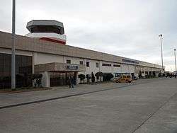
Samsun-Çarşamba Airport
| Samsun Çarşamba Airport Samsun Çarşamba Havalimanı | |||||||||||
|---|---|---|---|---|---|---|---|---|---|---|---|
 | |||||||||||
| Summary | |||||||||||
| Airport type | Public | ||||||||||
| Operator | General Directorate of State Airports Authority | ||||||||||
| Serves | Samsun, Turkey | ||||||||||
| Coordinates | 41°15′56″N 36°32′55″E / 41.26556°N 36.54861°E | ||||||||||
| Website | http://www.carsamba.dhmi.gov.tr/ | ||||||||||
| Map | |||||||||||
 SZF Location of airport in Turkey | |||||||||||
| Runways | |||||||||||
| |||||||||||

Control Tower
Samsun Çarşamba Airport (IATA: SZF, ICAO: LTFH) (Turkish: Samsun Çarşamba Havalimanı) is a public airport in Samsun, Turkey. Opened in 1998, it is 23 km from Samsun.
The passenger terminal of the airport covers an area of 4,725 m² and has a parking lot for 246 cars.
Airlines and destinations
| Airlines | Destinations |
|---|---|
| Onur Air | Istanbul–Atatürk |
| Pegasus Airlines | Istanbul–Sabiha Gökçen, Izmir |
| SunExpress | Antalya, Izmir Seasonal: Düsseldorf, Frankfurt, Stuttgart |
| TUI fly Deutschland | Seasonal: Cologne/Bonn |
| Turkish Airlines | Istanbul–Atatürk Seasonal: Berlin–Tegel, Düsseldorf, Vienna |
| Turkish Airlines operated by AnadoluJet | Ankara, Bursa, İstanbul-Sabiha Gökçen |
Traffic Statistics
| Year (months) | Domestic | % change | International | % change | Total | % change |
|---|---|---|---|---|---|---|
| 2011 * | 1,060,473 | 89,685 | 1,150,158 | |||
| 2010 | 891,355 | 65,899 | 957,254 | |||
| 2009 | 779,794 | 87,068 | 866,862 | |||
| 2008 | 527,886 | 76,501 | 604,387 | |||
| 2007 | 485,772 | 70,024 | 555,796 |
(*)Source: DHMI.gov.tr[1]
Air traffic control
Air traffic controllers at the tower also control the nearby coastguard helicopters.
Future expansion
Construction of a taxiway would remove landing delays due to previously landed aircraft taxiing back down the runway. However to do this land adjacent to the airport would need to be purchased.
References
External links
- Accident history for SZF at Aviation Safety Network
- Airport information for LTFH at Great Circle Mapper.
- Current weather for LTFH at NOAA/NWS
- Airport information for LTFH at World Aero Data. Data current as of October 2006.
This article is issued from
Wikipedia.
The text is licensed under Creative Commons - Attribution - Sharealike.
Additional terms may apply for the media files.