Sam A. Baker State Park
| Sam A. Baker State Park | |
| Missouri State Park | |
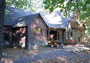 Dining lodge made of native stone and wood | |
| Country | United States |
|---|---|
| State | Missouri |
| County | Wayne |
| Elevation | 922 ft (281 m) [1] |
| Coordinates | 37°15′12″N 90°31′34″W / 37.25333°N 90.52611°WCoordinates: 37°15′12″N 90°31′34″W / 37.25333°N 90.52611°W [1] |
| Highest point | Mudlick Mountain |
| - elevation | 1,306 ft (398 m) [2] |
| - coordinates | 37°15′43″N 90°31′27″W / 37.26194°N 90.52417°W [2] |
| Area | 5,323.62 acres (2,154 ha) [3] |
| Established | 1926 |
| Management | Missouri Department of Natural Resources |
| - Park Office | Off Missouri Route 143 |
| - coordinates | 37°15′26.8″N 90°30′14.6″W / 37.257444°N 90.504056°W [4] |
 Location in Missouri | |
| Website: Sam A. Baker State Park | |
|
Sam A. Baker State Park Historic District | |
| Nearest city | Patterson, Missouri |
| Area | 4,860 acres (1,970 ha) |
| Built | 1933 |
| Architectural style | Rustic |
| MPS | ECW Architecture in Missouri State Parks 1933-1942 TR |
| NRHP Reference # | 85000540[5] |
| Added to NRHP | February 27, 1985 |
Sam A. Baker State Park is a state-owned, public recreation area encompassing 5,323 acres (2,154 ha) in the Saint Francois Mountains region of the Missouri Ozarks. The state park was acquired in 1926 and is named for Missouri governor Sam Aaron Baker who encouraged the development of the park in his home county. In the 1930s, the Civilian Conservation Corps added many structures to the park including the park office and visitors center, which was originally used as a stable, the stone dining lodge, most of the park's cabins, and the backpacking shelters on the Mudlick Trail.[6] Twenty-five buildings and five structures comprise the Sam A. Baker State Park Historic District, a national historic district listed on the National Register of Historic Places in 1985.[5][7]:439-467
Activities and amenities
- The park offers access to the St. Francis River and Big Creek for fishing, canoeing, and swimming.
- Camping: The park has 187 campsites, half of them electric and 18 rustic, plus air-conditioned cabins. A separate campground with 21 sites is available for use by equestrians.
- Trails: The 14-mile (23 km) Mudlick Trail is available for hiking, backpacking, and horseback riding. The Mudlick has three stone shelters available for backpackers, and views of the 4,420-acre (1,790 ha) Mudlick Mountain Wild Area and the 1,370-acre (550 ha) Mudlick Natural Area. There is also the 1.5-mile (2.4 km) Shut-Ins Trail, the Hollow Pass Trail, and the nearby Wappapello Section of the Ozark Trail. The park also has a 2-mile (3.2 km) paved bicycle trail open to cyclists, hikers, skateboarders, and roller skaters.
References
- 1 2 "Sam A Baker State Park". Geographic Names Information System. United States Geological Survey.
- 1 2 "Mudlick Mountain". Geographic Names Information System. United States Geological Survey.
- ↑ "State parks...estimated acres" (PDF). Revised Statewide Comprehensive Outdoor Recreation Plan: 2008-2012. Missouri Department of Natural Resources. pp. 142–143. Retrieved September 9, 2014.
- ↑ "Sam A. Baker State Park Visitors Center". Missouri State Parks. Missouri Department of Natural Resources. Retrieved October 1, 2015.
- 1 2 National Park Service (2010-07-09). "National Register Information System". National Register of Historic Places. National Park Service.
- ↑ "Sam A. Baker State Park". Missouri State Parks. Missouri Department of Natural Resources. Retrieved October 1, 2014.
- ↑ Bonnie Wright (1985). "National Register of Historic Places Inventory Nomination Form: Emergency Conservation Work (E.C.W.) Architecture in Missouri State Parks, 1933-1942" (PDF). Missouri Department of Natural Resources. Retrieved 2017-03-01. (includes photographs)
External links
| Wikimedia Commons has media related to Sam A. Baker State Park. |
- Sam A. Baker State Park Missouri Department of Natural Resources
- Sam A. Baker State Park Map Missouri Department of Natural Resources

