Tuzla
| Tuzla Тузла | |||
|---|---|---|---|
| City | |||
|
Tuzla | |||
| |||
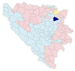
 Location of Tuzla within Bosnia and Herzegovina (dark blue) | |||
| Country | Bosnia and Herzegovina | ||
| Entity | The Federation | ||
| Canton | Tuzla Canton | ||
| Government | |||
| • Mayor | Jasmin Imamović (SDP) | ||
| Area | |||
| • City | 294 km2 (114 sq mi) | ||
| Elevation | 245 m (804 ft) | ||
| Population (2013 census) | |||
| • City | 80,570 | ||
| • Density | 410/km2 (1,100/sq mi) | ||
| • Urban | 120,441 | ||
| Time zone | CET (UTC+1) | ||
| • Summer (DST) | CEST (UTC+2) | ||
| Postal code | 75 000 | ||
| Area code(s) | (+387) 35 | ||
| Website |
www | ||
Tuzla is a city in Bosnia and Herzegovina. It is the seat of the Tuzla Canton and is the economic, scientific, cultural, educational, health and tourist centre of northeast Bosnia.[1] After Sarajevo and Banja Luka, Tuzla is the third largest city in Bosnia and Herzegovina. Preliminary results from the 2013 Census indicate that the municipality has a population of 120,441.[2]
Tuzla is an educational center and is home to two universities. It is also the main industrial machine and one of the leading economic strongholds of Bosnia with a wide and varied industrial sector including an expanding service sector thanks to its salt lake tourism. The city of Tuzla is home to Europe's only salt lake as part of its central park and has more than 100,000 people visiting its shores every year.[3] The history of the city goes back to the 9th century; modern Tuzla dates back to 1510 when it became an important garrison town in the Ottoman Empire.[4]
In Bosnia and Herzegovina, Tuzla is also regarded as one of the most multicultural cities in the country and has managed to keep the pluralist character of the city throughout the Bosnian War and after, with Bosniaks, Serbs, Croats and a small minority of Bosnian Jews residing in Tuzla.[5]
Etymology
The name "Tuzla" is the Ottoman Turkish word for salt mine, tuzla, and refers to the extensive salt deposits found underneath the city.
History
Early history
Archaeological evidence suggests that Tuzla was a rich Neolithic settlement. Being inhabited continuously for more than 6,000 years, Tuzla is one of the oldest European sustained settlements. During the period of the Roman Republic (before the area was conquered by Rome), Tuzla (or Salines as it was called at the time) was ruled by the Illyrian tribe Breuci.[6]
Middle Ages to 20th century
The city was first mentioned in 950 by Constantine Porphyrogenitus in his De Administrando Imperio as a fort named Salines (Greek: Σαλήνες). The name Soli was used in the Middle Ages. It means "salts" in Bosnian and the city's present name means "place of salt" in Ottoman Turkish.[7] During the Middle Ages it belonged mostly to the medieval Kingdom of Bosnia.
After the fall of the kingdom to the Ottoman Empire in 1463, the region was controlled by the House of Berislavić before the Ottomans occupied the villages of "Gornje Soli" and "Donje Soli" around 1512, and took control of the entire Usora in the 1530s.
It remained under Ottoman rule for nearly 400 years, where it was administered as part of the Sanjak of Zvornik. In 1878 it was annexed by Austria-Hungary. After the dissolution of the monarchy it became the part of the newly formed Kingdom of Yugoslavia. The Husino uprising took place in 1920.
In December 1944, the city was unsuccessfully attacked by Chetnik forces of Draža Mihailović along with the Serbian Assault Corps.[8][9] After the war it developed into a major industrial and cultural centre during the Communist period in the former Yugoslavia.
Bosnian War


In the 1990 elections the Reformists won control of the municipality being the only municipality in Bosnia where non-nationalists won. During the Bosnian war for independence between 1992–95 the town was the only municipality not governed by nationalist authorities. After Bosnia and Herzegovina declared independence and was recognized by the United Nations the city was besieged by Serbian forces. A few days later Serbian forces attacked Tuzla. The town was not spared the atrocities of the Bosnian war. 1992 Yugoslav People's Army column incident in Tuzla was an massacre of the unarmed 92nd Yugoslav People's Army (JNA) Motorized Brigade in the city of Tuzla that took place on 15 May 1992. The massacre occurred at the road junction of Brčanska Malta as the JNA was undergoing an agreed-upon withdrawal from the city. At least 93 members of the JNA were killed and 44 wounded during the attacks.
On 25 May 1995, an attack on Tuzla killed 71 people and injured 200 persons in what is referred to as the Tuzla massacre, when a shell hit the central street and its promenade. The youngest civilian who died in that massacre was only two years old.
Following the Dayton Peace Accords, Tuzla was the headquarters of the U.S. forces for the Multinational Division (MND) during Operation Joint Endeavour IFOR and subsequent SFOR.
Post-war independence
In February 2014 the city was the scene of the beginning of the 2014 unrest in Bosnia and Herzegovina, which quickly spread to dozens of cities and towns throughout Bosnia and Herzegovina.
Geography
Tuzla is located in the northeastern part of Bosnia, settled just underneath the Majevica mountain range, on the Jala River. The central zone lies in an east-west oriented plain, with residential areas in the north and south of the city located on the Ilinčica, Kicelj and Gradina Hills. It is 237 metres (778 feet) above sea level. The climate is moderate continental. There are abundant coal deposits in the region around Tuzla. 6 coal mines continue to operate around the city. Much of the coal mined in the area is used to power the Tuzla Power Plant, which is the largest power plant in Bosnia and Herzegovina.
Salt deposits
Extractions of the city's salt deposits, particularly in the 20th century, have caused sections of the city center to sink. Structures in the "sinking area" either collapsed or were demolished, and there are few structures in the city that predate the 20th century, despite the fact that the city was founded over 1000 years ago.
Pannonian Lakes
Tuzla is the only city in Europe that has a salt lake at its centre. The ancient Pannonian Sea dried up around 10 million years ago, but work by researchers and scientists has now enabled a level of saline water to be kept stable at the surface, and in 2003 the Pannonian Lake was opened.
A second lake that includes artificial waterfalls was inaugurated in 2008. An archaeological park and replica Neolithic lake dwellings were also incorporated into the scheme, providing information about the different cultures which left their material and spiritual mark here. The site has become an international tourist destination.[10]
A third lake was completed in August 2012. Construction expenses for this were nearly 2 million Bosnian marks (ca. 1 million euros). This third lake also contains 2 water slides which are an attraction for the younger population.
The summer season of 2013 recorded approximately 5,000 visitors per day (c. 450,000 for 3 months).
Climate
| Climate data for Tuzla | |||||||||||||
|---|---|---|---|---|---|---|---|---|---|---|---|---|---|
| Month | Jan | Feb | Mar | Apr | May | Jun | Jul | Aug | Sep | Oct | Nov | Dec | Year |
| Record high °C (°F) | 20.4 (68.7) |
25.3 (77.5) |
30.0 (86) |
33.0 (91.4) |
34.1 (93.4) |
37.2 (99) |
40.7 (105.3) |
40.5 (104.9) |
38.2 (100.8) |
31.0 (87.8) |
26.0 (78.8) |
20.6 (69.1) |
40.7 (105.3) |
| Average high °C (°F) | 5.6 (42.1) |
8.0 (46.4) |
13.0 (55.4) |
18.2 (64.8) |
22.6 (72.7) |
26.0 (78.8) |
28.5 (83.3) |
28.8 (83.8) |
23.2 (73.8) |
18.4 (65.1) |
12.2 (54) |
5.7 (42.3) |
17.5 (63.5) |
| Daily mean °C (°F) | 0.9 (33.6) |
2.4 (36.3) |
7.0 (44.6) |
11.5 (52.7) |
16.4 (61.5) |
19.8 (67.6) |
21.8 (71.2) |
21.7 (71.1) |
16.5 (61.7) |
11.8 (53.2) |
6.9 (44.4) |
1.6 (34.9) |
11.5 (52.7) |
| Average low °C (°F) | −2.7 (27.1) |
−2.0 (28.4) |
1.4 (34.5) |
5.4 (41.7) |
9.4 (48.9) |
13.0 (55.4) |
14.7 (58.5) |
14.5 (58.1) |
10.5 (50.9) |
6.3 (43.3) |
2.2 (36) |
−1.8 (28.8) |
5.9 (42.6) |
| Record low °C (°F) | −25.8 (−14.4) |
−22.0 (−7.6) |
−12.2 (10) |
−4.9 (23.2) |
−0.8 (30.6) |
4.0 (39.2) |
7.0 (44.6) |
5.3 (41.5) |
−1.0 (30.2) |
−8.0 (17.6) |
−13.0 (8.6) |
−17.7 (0.1) |
−25.8 (−14.4) |
| Average precipitation mm (inches) | 58.0 (2.283) |
50.0 (1.969) |
57.6 (2.268) |
70.0 (2.756) |
97.9 (3.854) |
115.6 (4.551) |
92.7 (3.65) |
67.8 (2.669) |
82.3 (3.24) |
81.6 (3.213) |
72.6 (2.858) |
67.2 (2.646) |
913.3 (35.957) |
| Average precipitation days (≥ 1.0 mm) | 9.6 | 11.0 | 9.5 | 10.1 | 12.2 | 11.8 | 8.3 | 7.0 | 8.0 | 8.0 | 6.5 | 9.9 | 111.9 |
| Average relative humidity (%) (at 14:00) | 73 | 65 | 54 | 56 | 56 | 57 | 56 | 55 | 58 | 63 | 68 | 76 | 61 |
| Mean monthly sunshine hours | 60 | 80 | 130 | 153 | 192 | 197 | 238 | 232 | 170 | 124 | 73 | 56 | 1,705 |
| Source: Deutscher Wetterdienst (temperatures, 1991–2016, extremes 1961–2015, precipitation, 1991–2015, precipitation days, 2005–2016, humidity, 1973–1993 and sun, 1961–1990)[11][12][lower-alpha 1] | |||||||||||||
Administration
Tuzla is the seat of the Tuzla Canton, which is a canton of the Federation of Bosnia and Herzegovina, as well as of Tuzla Municipality, which is one of the 13 municipalities that together constitute the Tuzla Canton. Administratively, Tuzla is divided into 39 mjesne zajednice (local districts).
Apart from Tuzla, the municipality incorporates several other adjacent settlements, including the town of Gornja Tuzla (Upper Tuzla), as well as the villages of Husino, Par Selo, Simin Han, Obodnica, Kamenjaši, Plane, Šići and others.
The Mayor of City of Tuzla is Jasmin Imamović, a writer and lawyer born in 1957, of the Social Democratic Party of Bosnia and Herzegovina. He was reelected to a third term in 2008.
The City council of Tuzla has 30 members, of the following parties:
- Social Democratic Party of Bosnia and Herzegovina (SDP) - 10 members
- Party of Democratic Action (SDA) - 6 members
- Bosnian Party (BOSS) - 2 members
- Party for Bosnia and Herzegovina (SBiH) - 1 members.
Demographics


Demographics in Tuzla municipality:
1971 census
Total: 107,293
- 53,271 (49.65%) - Bosniaks
- 27,735 (25.84%) - Croats
- 21,089 (19.65%) - Serbs
- 2,540 (2.36%) - Yugoslavs
- 2,658 (2.47%) - others and unknown
1981 census
Total: 121,717
- 52,400 (43.05%) - Bosniaks
- 24,811 (20.38%) - Croats
- 20,261 (16.64%) - Serbs
- 19,059 (15.65%) - Yugoslavs
- 5,186 (4.26%) - others and unknown
1991 census

Total: 131,618
- 62,669 (47.61%) - Bosniaks
- 21,995 (16.71%) - Yugoslavs
- 20,398 (15.49%) - Croats
- 20,271 (15.40%) - Serbs
- 6,285 (4.77%) - others and unknown
2013 census
Total: 110,979
- 80,774 (72.78%) - Bosniaks
- 15,396 (13.87%) - Croats
- 3,378 (3.04%) - Serbs
- 11,431 (10.30%) - others and unknown
Source[13]
Culture
Arts

One of the most influential writers in the Balkans, Meša Selimović hails from Tuzla, and Tuzla hosts the annual Meša Selimović book festival in July, where an award for the best novel written in the languages of Bosnia and Herzegovina, Croatia, Serbia and Montenegro is presented.
The first professional theatre in Tuzla, Narodno Pozorište u Tuzli (The National Theatre of Tuzla), was founded by the brothers Mihajlo and Živko Crnogorčević in 1898 during Austro-Hungarian rule, and is the oldest theatre in the country. The theatre is working continuously since 1944.
The Portrait Gallery has continuous exhibitions of work by local and international artists.
The Ismet Mujezinović Gallery is mainly dedicated to the late Ismet Mujezinović, a famous painter from Tuzla.
The Eastern Bosnia Museum exhibits archaeological, ethnological, historical and artistic pieces and artifacts from the whole region.
An open-air museum at Solni Trg, opened in 2004, tells the story of salt production in Tuzla.
Religion
Apart from Tuzla's many mosques, there is also an Orthodox church that went untouched throughout the war.[14]
The Franciscan monastery in town is still very active as there is a sizable Catholic community in Tuzla. Just outside the town, in the nearby village of Breska, is a 200-year-old Catholic church.[14] Tuzla is also home to an old Jewish cemetery which recently underwent renovations, organized by the OPEN Organization of Tuzla and the Jewish Municipality of Tuzla.[15]
Sports
Several sports teams from Tuzla have participated in international competitions. Almost all of Tuzla's sports teams are named Sloboda, meaning freedom. The most popular sports in Tuzla include football (FK Sloboda); basketball (OKK Sloboda), karate (KBS Tuzla-Sinbra) and many others. The women's basketball team Jedinstvo Aida were European club champions in the late 1980s, with the most famous sportswoman from Tuzla in their midst – Razija Mujanović.
Miscellaneous
On 1 September 2007, 6,980 couples kissed for 10 seconds in Tuzla, Bosnia erasing the previous Guinness World kissing Records of the Philippines and Hungary (for synchronised osculation in 2004 with 5,327 Filipino couples, overtaken by Hungary in 2005 with 5,875 couples; Filipinos came back in February 2010 with 6,124 couples but the Hungarians responded in June 2010 with 6,613 couples). The record now awaits official certification.[16]
On 26 September 2008, Tuzla began offering free wireless internet access in the city center.[17]
Transport

Tuzla has an international airport located at Dubrave (IATA code: TZL), and an effective and well-developed public bus network. There are plans to introduce a trolleybus network in the city soon.
The airport was opened and obtained ICAO certificate for civilian Air traffic in 2008. The airport had comprised a portion of "Eagle Base", an American military base that has been home to NATO troops serving in SFOR, Bosnia's stabilization force. Nowadays former Eagle Base become home of Bosnian Military Forces. In 2013. the airport became a base for Wizz Air. Tuzla International Airport nowadays has connection to 17+ European cities and expanding. More than 300000 passengers have been traveled via Tuzla International Airport in 2016. More about flights, statistics and other information can be found on Tuzla International Airport official Website
Tuzla is well connected with other major cities in Bosnia and Herzegovina and even with some European cities via its Bus connections. Bus and Taxi traffic is very well organised in Tuzla and is affordable to its citizens. Bus station was built in 1970 and completely renovated and modernized in 2017. More information can be found on official websites such as Tuzla Bus Station website Town of Tuzla official website Tuzla City Services
Tuzla has a railway station that has passenger services to Doboj,[18] from where trains run to Sarajevo, Zagreb, and Belgrade. The services to Brčko were discontinued in 2012.[19]
Education
Tuzla is home to the University of Tuzla, with 16,500 students,[20] and also the American University in Bosnia and Herzegovina.
Universities
Schools
- Association Citizens Educational Center
- Behram-Begova Medresa Tuzla
- Secondary Music School in Tuzla
- Gimnazija Meša Selimović
- Gimnazija Ismet Mujezinović
- Građevinsko-Geodetska Škola Tuzla
- Katolički Školski Centar "Sv.Franjo" Tuzla
- Ekonomsko-Trgovinska Škola Tuzla
- Elektrotehnička Škola Tuzla
- Medicinska Škola Tuzla
- Mješovita Mašinska-Saobraćajna Škola Tuzla
Notable people
- Amer Delić, professional tennis player
- Andrea Petković, German professional tennis player
- Andreja Pejić, Australian model
- Damir Mulaomerović, Croatian basketball player
- Denis Azabagić, guitarist
- Emir Hadžihafizbegović, actor
- Emir Hot, guitarist
- Emir Vildić, musician
- Lepa Brena, singer
- Maya Sar, singer
- Meša Selimović, writer
- Milan Đurić, footballer
- Mirza Delibašić, basketball player, Olympic, World and European champion, FIBA Hall of Fame member
- Miralem Pjanić, footballer
- Miroslav Tadić, musician
- Muhamed Hevaji Uskufi Bosnevi, writer, poet
- Muhamed Hadžiefendić, SS commander
- Muhamed Konjić, retired football player
- Nesim Tahirović, painter
- Jusuf Nurkić, basketball player for Portland Trail Blazers
- Sanel Redžić, cllasic guitar player - http://www.sanelredzic.com/
- Sanja Maletić, singer
- Seada Palavrić, Judge of the Constitutional Court of Bosnia and Herzegovina
- Selma Bajrami, singer
- Svetlana Dašić-Kitić, retired handball player, Voted World Player of the Year 1988 by the International Handball Federation
- Zlatan Saračević, retired olimpic contestant, European Indoor Championships 1980 Sindelfingen gold winner - shot put.
International relations
Twin towns – Sister cities
Tuzla is twinned with:
Gallery
 Old town Tuzla
 Part of old town
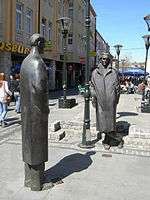
 Pedestrian street
 Public fountain and city mosque
 WWII memorial
 Arch of Tuzla
 Kapija
Notes
- ↑ Station ID for Tuzla is 14557 Use this station ID to locate the sunshine duration
References
- ↑ "BH Tourism - Tuzla". Bhtourism.ba. Retrieved 2013-11-24.
- ↑ "Preliminary Results Of the 2013 Census of Population, Households and Dwellings in Bosnia and Herzegovina" (PDF). Agency for Statistics of Bosnia and Herzegovina. 5 November 2013. Retrieved 10 November 2013.
- ↑ "Tuzla Culture | Tuzla History". World66.com. Retrieved 2013-11-24.
- ↑ "Tuzla (Bosnia and Herzegovina) - Encyclopædia Britannica". Britannica.com. Retrieved 2013-11-24.
- ↑ "Tolerance: Additional Resources". Beyond Intractability. Retrieved 2013-11-24.
- ↑ "Rimski vuk i ilirska zmija. Posljednja borba". Retrieved 30 December 2015.
- ↑ "The Journal of the Anthropological institute". Retrieved 30 December 2015.
- ↑ Dimitrije Ljotić and his ZBOR at the Wayback Machine (archive index)
- ↑ "Tuzlarije". Bhstring.net. Retrieved 2013-11-24.
- ↑ "Tuzla - INFIORE Project". Adriaticoinfiore.eu. Retrieved 2013-11-24.
- ↑ "Klimatafel von Tuzla / Bosnien und Herzegowina" (PDF). Baseline climate means (1961-1990) from stations all over the world (in German). Deutscher Wetterdienst. Retrieved 22 November 2016.
- ↑ "Station 14557 Tuzla". Global station data 1961–1990—Sunshine Duration. Deutscher Wetterdienst. Retrieved 22 November 2016.
- ↑ http://www.popis2013.ba/popis2013/doc/Popis2013prvoIzdanje.pdf
- 1 2 "BH Tourism - What to see and do". Bhtourism.ba. Retrieved 24 November 2013.
- ↑ Akcija uređenja jevrejskog groblja u Tuzli [Renovation of the Jewish Cemetery in Tuzla] (YouTube) (in Bosnian). Tuzlarije.net. 2010. Retrieved 19 August 2012.
- ↑ "The Sydney Morning Herald Blogs: Stay in Touch". Blogs.smh.com.au. 2007-09-04. Retrieved 2013-11-24.
- ↑ Archived March 12, 2010, at the Wayback Machine.
- ↑ ZFBH. "Bosnian Railway Timetables". Retrieved 27 October 2013.
- ↑ "Voz na relaciji Tuzla - Brčko ukida se od 1. decembra". Nezavisne Novine. 30 November 2012. Retrieved 27 October 2013.
- ↑ Archived June 11, 2009, at the Wayback Machine.
External links
| Wikimedia Commons has media related to Tuzla. |
| Wikivoyage has a travel guide for Tuzla. |
| Wikisource has the text of the 1911 Encyclopædia Britannica article Dolnja Tuzla. |
- Official website (in Bosnian) (in English)
- Tuzlanski Info Portal local news website (in Bosnian)
Coordinates: 44°32′17″N 18°40′34″E / 44.53806°N 18.67611°E
.jpg)


