Laurierville, Quebec
| Laurierville | |
|---|---|
| Municipality | |
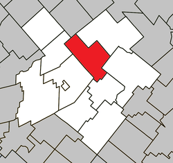
 Location within L'Érable RCM. | |
 Laurierville Location in southern Quebec. | |
| Coordinates: 46°18′N 71°39′W / 46.300°N 71.650°WCoordinates: 46°18′N 71°39′W / 46.300°N 71.650°W[1] | |
| Country |
|
| Province |
|
| Region | Centre-du-Québec |
| RCM | L'Érable |
| Constituted | November 26, 1997 |
| Government[2] | |
| • Mayor | Marc Simoneau |
| • Federal riding | Mégantic—L'Érable |
| • Prov. riding | Lotbinière |
| Area[2][3] | |
| • Total | 108.80 km2 (42.01 sq mi) |
| • Land | 106.97 km2 (41.30 sq mi) |
| Population (2011)[3] | |
| • Total | 1,454 |
| • Density | 13.6/km2 (35/sq mi) |
| • Pop 2006-2011 |
|
| • Dwellings | 602 |
| Time zone | EST (UTC−5) |
| • Summer (DST) | EDT (UTC−4) |
| Postal code(s) | G0S 1P0 |
| Area code(s) | 819 |
| Highways |
|
| Website |
www |
Laurierville is a municipality in the Centre-du-Québec region of the province of Quebec in Canada.
It was constituted on November 26, 1997 by the amalgamation of the village municipality of Laurierville and the municipality of Sainte-Julie (the latter not to be confused with a different, modern-day Sainte-Julie in Montérégie). Laurierville contains the new storage warehouse of the Federation of Maple Sugar Producers of Quebec.
References
This article is issued from
Wikipedia.
The text is licensed under Creative Commons - Attribution - Sharealike.
Additional terms may apply for the media files.
