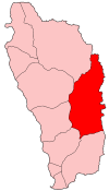
Saint David Parish, Dominica
| Saint David | |
| Parish | |
.jpg) Carib Territory coast | |
| Country | Dominica |
|---|---|
| Capital | Castle Bruce |
| - coordinates | 15°25′N 61°17′W / 15.417°N 61.283°WCoordinates: 15°25′N 61°17′W / 15.417°N 61.283°W |
| Area | 131.5 km2 (51 sq mi) |
| Population | 6,043 (2011) |
| Density | 46/km2 (119/sq mi) |
| Timezone | UTC-4 |
| ISO 3166-2 | DM-03 |
 | |
Saint David is one of Dominica's ten administrative parishes, located on the eastern side of the island. It is bordered by St. Andrew to the north; St. Joseph, St. Paul and St. George to the west; and St. Patrick to the south. It has an area of 131.6 km² (50.8 mi²),[1] and has a population of 6,789.[2]
Settlements
Its largest settlement is Castle Bruce, with a population of 1,653.[2] It includes the Indigenous community of the *Carib Territory. (Kalinago Territory) which has a population of about 3000 spread across 7 hamlets. Other villages include:
- Grand Fond
- Rosalie
- Good Hope
- Petit Soufrière
- Riviere Cyrique
- Morne Jaune
- San Sauveur
- Carib Territory
- Atkinson
- Antrizle
Areas of interest
The northern area of the parish is also home to the island's Carib Territory, in and around which 3,000 pure, indigenous Caribs live.
References
This article is issued from
Wikipedia.
The text is licensed under Creative Commons - Attribution - Sharealike.
Additional terms may apply for the media files.