Sacking of Lawrence
| ||||||||||||||||||||||||||||||
The Siege of Lawrence occurred on May 21, 1856, when pro-slavery activists attacked and ransacked the town of Lawrence, Kansas, which had been founded by anti-slavery settlers to help ensure that Kansas would become a "free state". The incident made worse the guerrilla war in Kansas Territory that became known as Bleeding Kansas.
Background
Lawrence was founded in 1854 by anti-slavery settlers, many with the financial support of the New England Emigrant Aid Company. The town soon became the center of pro-slavery violence in Kansas Territory. While the village had been besieged in December 1855, it was not directly attacked at that time. The non-fatal shooting of Douglas County Sheriff Samuel J. Jones who was attempting to arrest free-state settlers in Lawrence, is considered by the abolitionists the immediate cause of the violence.[1] Lawrence residents drove Jones out of town after they shot him, and on May 11, Federal Marshal J. B. Donaldson proclaimed the act had interfered with the execution of warrants against the extralegal Free-State legislature, which was set up in opposition to the official pro-slavery territorial government.[1] Based on this proclamation, as well the finding by a grand jury that Lawrence's Free State Hotel was actually built to use as a fort, Sheriff Jones assembled a posse of about 800 southern settlers to enter Lawrence, disarm the citizens, destroy the anti-slavery presses, and dismantle the Free State Hotel.[2][3]
Siege

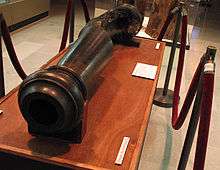
On May 21, 1856, the posse led by Sheriff Jones neared the town. A large force was stationed on the high ground at Mount Oread, and a cannon was placed to cover and command the area. The house of Charles L. Robinson, later to become the first governor of Kansas, was taken over as Jones's headquarters. Every road to the town and on the opposite side of the river was guarded by posse members to prevent the free soilers from fleeing. Two flags were to be seen that day: a blood-red flag inscribed with "Southern-rights" and the "stars and stripes."[4]
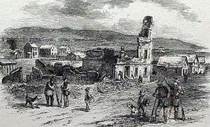
The two printing offices were sacked first; their presses were smashed and the type was thrown in the river. The next target was the impressive Free State Hotel. The first cannon shot was aimed at it by David Rice Atchison, who missed. Nearly fifty more shots were fired at it, but even direct hits had little effect upon its walls. Jones then decided to blow it up. Several kegs of gunpowder were exploded in the building, but even they caused little damage to the walls. As a last resort, the hotel was torched, and by early evening it had become a roofless, smoldering ruin. The posse looted the half-deserted town,[4] and burned Robinson's home on Mount Oread as they retreated.
One man had died during the attack, a posse member who was struck by falling masonry.[5]
See also
- Kansas-Nebraska Act
- Lawrence Massacre, a separate attack on Lawrence on August 21, 1863, during the American Civil War.
- List of battles fought in Kansas
References
- 1 2 Durwood Ball, Army Regulars on the Western Frontier, 1848-1861 (Norman: University of Oklahoma Press, 2001), 174
- ↑ Durwood Ball, Army Regulars on the Western Frontier, 1848-1861 (Norman: University of Oklahoma Press, 2001), 175
- ↑ Jay Monaghan, Civil War on the Western Border, 1854-1865 (Lincoln: University of Nebraska Press, 1984), 57
- 1 2 Monaghan, Civil War on the Western Border, 58
- ↑ Ross Drake, "The Law That Ripped America In Two," Smithsonian Magazine, May 1, 2004.
External links
- Eyewitness account of the Sack of Lawrence, 1856
- Drake, Ross. "The Law That Ripped America In Two." Smithsonian Magazine. May 1, 2004
- Griffin, C. S. "The University of Kansas and the Sack of Lawrence: A Problem of Intellectual Honesty." Kansas Historical Quarterly 34, no. 4 (Winter 1968): 409-426.
- Smiley, Jane. The All-True Travels and Adventures of Lidie Newton: A Novel (1998; ISBN 0-00-225743-2). Historical novel relating to the sack of Lawrence and other events in Kansas Territory's history.
- Territorial Kansas Online: A Virtual Repository for Kansas Territorial History.
Coordinates: 38°57′36″N 95°15′12″W / 38.96000°N 95.25333°W

.svg.png)