Sablé-sur-Sarthe
| Sablé-sur-Sarthe | ||
|---|---|---|
| Commune | ||
|
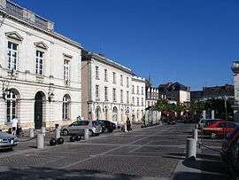
The town hall of Sablé in Raphaël Élizé square. | ||
| ||
 Sablé-sur-Sarthe | ||
|
Location within Pays de la Loire region  Sablé-sur-Sarthe | ||
| Coordinates: 47°51′02″N 0°19′45″W / 47.8505°N 0.3292°WCoordinates: 47°51′02″N 0°19′45″W / 47.8505°N 0.3292°W | ||
| Country | France | |
| Region | Pays de la Loire | |
| Department | Sarthe | |
| Arrondissement | La Flèche | |
| Canton | Sablé-sur-Sarthe | |
| Government | ||
| • Mayor (2008–2014) | Marc Joulaud | |
| Area1 | 36.92 km2 (14.25 sq mi) | |
| Population (2006)2 | 13,141 | |
| • Density | 360/km2 (920/sq mi) | |
| Time zone | CET (UTC+1) | |
| • Summer (DST) | CEST (UTC+2) | |
| INSEE/Postal code | 72264 /72300 | |
|
1 French Land Register data, which excludes lakes, ponds, glaciers > 1 km² (0.386 sq mi or 247 acres) and river estuaries. 2 Population without double counting: residents of multiple communes (e.g., students and military personnel) only counted once. | ||
.svg.png)
Sablé-sur-Sarthe, commonly referred to as Sablé, is a commune in the Sarthe department in the Pays de la Loire region in west France. It is located c.50km northeast of Angers.
Geography
The Vaige forms part of the commune's north-western border, flows southwards through the middle of the commune, then flows into the Sarthe River in the town of Sablé-sur-Sarthe.
History
François Fillon was mayor of Sablé from 1983 to 2001.
Tourism
The town is a hub for river cruising along the Sarthe.
Points of interest
See also
References
External links
| Wikimedia Commons has media related to Sablé-sur-Sarthe. |
- Town council website
-
 Chisholm, Hugh, ed. (1911). "Sablé". Encyclopædia Britannica (11th ed.). Cambridge University Press.
This article is issued from
Wikipedia.
The text is licensed under Creative Commons - Attribution - Sharealike.
Additional terms may apply for the media files.