Oklahoma State Highway 55
| ||||
|---|---|---|---|---|
 | ||||
| Route information | ||||
| Maintained by ODOT | ||||
| Length: | 39.9 mi[1] (64.2 km) | |||
| Major junctions | ||||
| West end: |
| |||
| East end: |
| |||
| Highway system | ||||
|
Oklahoma State Highway System
| ||||

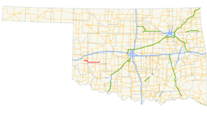
State Highway 55 is a state highway in western Oklahoma. It runs for 39.9 miles (64.2 km)[1] from Carter, Oklahoma to the unincorporated community of Lake Valley. It has no lettered spur routes.
Route description
SH-55 begins at State Highway 34 in Carter, in eastern Beckham Co.. It heads east for six miles (10 km), where it meets State Highway 6 and overlaps it to the south. After running along the Beckham/Washita Co. line, it splits off to the east near Retrop. It then meets State Highway 44 in Sentinel. Seven miles later it meets US-183 in Rocky. It then terminates at State Highway 54 in Lake Valley.
Junction list
| County | Location | mi[1] | km | Destinations | Notes |
|---|---|---|---|---|---|
| Beckham | Carter | 0.0 | 0.0 | Western terminus | |
| | 5.9 | 9.5 | Northern terminus of SH-6 concurrency | ||
| Beckham–Washita county line | Retrop | 10.9 | 17.5 | Southern terminus of SH-6 concurrency | |
| Washita | Sentinel | 21.4 | 34.4 | Southern terminus of SH-44 concurrency | |
| 21.5 | 34.6 | Northern terminus of SH-44 concurrency | |||
| Rocky | 28.0 | 45.1 | |||
| Lake Valley | 39.9 | 64.2 | |||
1.000 mi = 1.609 km; 1.000 km = 0.621 mi
| |||||
References
- 1 2 3 Google (November 6, 2012). "Oklahoma State Highway 55" (Map). Google Maps. Google. Retrieved November 6, 2012.
External links
This article is issued from
Wikipedia.
The text is licensed under Creative Commons - Attribution - Sharealike.
Additional terms may apply for the media files.