S'illot (Mallorca)
| S'illot | |
|---|---|
| Town | |
|
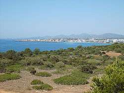
View of the bay of S'illot and Sa Coma | |
| Etymology: Catalan for "islet" | |
 S'illot S'illot is located in Majorca | |
| Coordinates: 39°34′37″N 3°22′19″E / 39.577°N 3.372°E | |
| Country | Spain |
| Autonomous Community | Balearic Islands |
| Island | Majorca |
| Population (2016) | |
| • Total | 1,988[1] |
S'illot is a small tourist town on the south east coast of Majorca, Spain, divided between the council areas of Manacor and Sant Llorenç des Cardassar. "Illot" is Catalan for "islet", and the name is derived from a small rocky island off the coast. The little cove of Cala Morlanda and the wide beach of Cala Moreia are situated to the south, while the resort of Sa Coma lies immediately to the north. The nearby small cove of Caló d'en Rafalino, south of Cala Morlanda, has a naturist beach. S'illot originated as summer resort for the inhabitants of Manacor in the 1930s. A range of seaside leisure activities take place in the town. At the entrance to the village there is prehistoric settlement that is well preserved.[2]
The town is reached from Palma and the airport by using the Autovia MA-15. Tourism is its primary economic activity, although there is still a very small working boatyard, with working fishing boats. It is near the larger town of Porto Cristo, and other tourist resorts such as Sa Coma which seamlessly joins it to the north and Cala Millor. The resort works well for young, old, singles, couples and families.
The town which has many Mallorcan people living there as well as many hotels is mostly flat and easy to walk around. There are a number of bus services which run through the town and mostly go to local places along the coast but also go as far afield as Inca. Cars, motorcycles, electric scooters, cycles and other forms of transportation can be hired. There is ample free parking. There is also a Dive shop where diving gear can be hired.
The town has a small crazy golf course and a tennis court. Also a bowls area (bring your own balls). It has a beach which is of fair size and there is another beach in Sa Coma about ten minutes walk away. There is also a headland of craggy rock sticking out into the sea. Some people fish from various places in the sea and river and at times like when it rains, a school of slim fish about a foot long can be seen.
It has a wide selection of small shops, with tourist souvenirs, clothes, nick-knacks and such as well as many mini-marts, most of which are Spar stores, many of which are open on Sundays. There is a small Eroski store called "aprop" which is cheaper as well as a large Eroski hypermarket at the other end of Sa Coma, about 15 minutes walk away. There is a pharmacy and a number of doctor's clinics near the beach. There is also a tourist office (open 9-3, Mon to Sat) at Carrer dels Sipions and Carrer Del Tamarell, close by "aprop". Not many places to change money though so best to change it at the airport. There are ATM's.
There are many eating places and some bars. The liveliest nightspot in the town is Pub Sauba, the Crazy Monkey which opens till 6am and the karaoke bar Olympic nearby. It is a very quite place where most of the entertainment takes place in the hotels or small bars and restaurants.
The main season is beginning of May till end of October. Things are very quiet outside of that.
Tip: Visit the Manacor market on Monday morning. It is an easy 15 minute drive away and it is a huge market (as big as the Inca market) in the centre of town, radiating from the church, whose spire you can see when approaching town, down to the Mercadona store. Manacor also has a Lidl.
Population
It is difficult to measure the population of this tourist town due to the its membership of two different municipalities. According to data from 2016, 243 inhabitants lived in the Sant Llorenç part and 1745 in the Manacor part. However, the latter figure also includes residents of the small resort of Cala Morlanda.[1] As many of the dwellings are second homes, the population increases notably the summer months.[2]
Monuments and places of interest
Within the current town there are the remains of the Talaiotic village of S'illot, dated to around 1100 BC. The site reflects the Talaiotic culture of the Balearic islands between the late 2nd millennium BC and the Punic Wars in the late 1st millennium BC.[3] The inhabitants of the settlement mainly practiced agriculture. Of great importance were hunting and the breeding of pigs and sheep. At the village's centre was a square talaiot (a megalithic structure of uncertain purpose) surrounded by 35 houses, which in turn were surrounded by the defensive wall of the town. In 123 BC the settlement was abandoned as a result of Roman colonization of the island. The remains of a settlement built of many, many stones from tiny to large can still be seen. It is well documented with a series of viewing platforms and diagrams and is unfortunately largely overlooked, not being sign posted.
References
- 1 2 "List of place name: Population of the Continuous Municipal Register by Population Unit at 1st January 2016". Instituto Nacional de Estadística. Retrieved 26 July 2017.
- 1 2 "s'Illot". visitmanacor.com. Retrieved 26 July 2017.
- ↑ "Benvinguts a la web del poblat talaiòtic de s'illot" [Welcome to the Website of Talaiotic S'illot] (in Catalan). Ajuntament de Sant Llorenç des Cardassar. Retrieved 4 June 2017.
External links
Coordinates: 39°34′37″N 3°22′19″E / 39.577°N 3.372°E
| Wikimedia Commons has media related to S'Illot. |
