Ruvo di Puglia
| Ruvo di Puglia | ||
|---|---|---|
| Comune | ||
| Comune di Ruvo di Puglia | ||
|
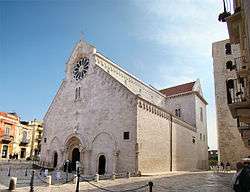
The cathedral | ||
| ||
 Ruvo di Puglia Location of Ruvo di Puglia in Italy | ||
| Coordinates: 41°07′N 16°29′E / 41.117°N 16.483°E | ||
| Country | Italy | |
| Region | Apulia | |
| Province / Metropolitan city | Bari | |
| Frazioni | Calendano | |
| Government | ||
| • Mayor | Pasquale Ninni Chieco | |
| Area | ||
| • Total | 221 km2 (85 sq mi) | |
| Elevation | 240 m (790 ft) | |
| Population (1 January 2015)[1] | ||
| • Total | 25,574 | |
| • Density | 120/km2 (300/sq mi) | |
| Demonym(s) | Ruvesi | |
| Time zone | CET (UTC+1) | |
| • Summer (DST) | CEST (UTC+2) | |
| Postal code | 70037 | |
| Dialing code | 080 | |
| Patron saint | Saint Blaise | |
| Saint day | February 3 | |
| Website | Official website | |
Ruvo di Puglia is a town and comune in the Metropolitan City of Bari, Apulia, southern Italy, that is essentially devoted to agriculture, wine and olive growing. It is part of the Murge karst landscape.
Geography and territory
Ruvo's territory is known for its vineyards, olive groves and sowable fields, and is one of the largest in the province of Bari. Very interesting is its wooded area, with many downy oak trees (Quercus pubescens) and a considerable underwood. Ruvo's territory is comprised in the Italian Alta Murgia National Park and shows typical elements of the Apulian karst landscape: sinkholes, karst valleys also known as "lame", among which we mention the upper course of Lama Balice and various caves. Two important caves to mention are the "Grave della Ferratella" (the deepest cave in the Apulia region), and the nearby "Abisso di Notarvincenzo" (the deepest in Ruvo). They are located near the wide and green Ferratella "Lama" (valley) which has to be considered as the Gate of the National Park af Alta Murgia.
History

The most ancient archaeological findings from the area date to the 9th century BC. The area was settled by the Peucetians. The painted Tomb of the Dancers is an important archeological find which is evidence for their presence. In the 3rd century BC it commerced with the Greater Greece, Etruria and Greece. Under the Roman Empire it was first a military stronghold and later a municipum; then it was ruled by the Byzantines, the Saracens and the Normans. Later it was part of the county of Conversano.
After the Aragonese and French dominations it was a fief of the Carafa family, until the abolition of feudalism in 1806.
Main sights
- The Cathedral is a prime example of Apulian Romanesque architecture. The façade has three portals and numerous decorations, depicting Christian symbols as well as griffins and other fantastic figures. There are two rose windows. The interior has a nave and two aisles ending with a transept. Among the numerous works of art are a wooden statue and the reliquary of Saint Blaise, a fresco portraying the Madonna and Child with St. Sebastian, a panel of the Virgin of Constantinople and a noteworthy wooden cross. Under the church are the remains of the Palaeo-Christian church and Roman tombs.
- Palazzo Jatta (19th century)
- Church of the Madonna di Calendano, in the frazione of the same name.
References
External links
| Wikimedia Commons has media related to Ruvo di Puglia. |
- Official website (in Italian)
- Web page about the landscape of Ruvo (in Italian)
- Tourist Audio guide APP for smartphones (in Italian)

