Rusutsu, Hokkaido
| Rusutsu 留寿都村 | |||
|---|---|---|---|
| Village | |||
|
Rusutsu Village hall | |||
| |||
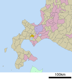 Location of Rusutsu in Hokkaido (Shiribeshi Subprefecture) | |||
 Rusutsu Location in Japan | |||
| Coordinates: 42°44′N 140°53′E / 42.733°N 140.883°ECoordinates: 42°44′N 140°53′E / 42.733°N 140.883°E | |||
| Country | Japan | ||
| Region | Hokkaido | ||
| Prefecture | Hokkaido (Shiribeshi Subprefecture) | ||
| District | Abuta | ||
| Government | |||
| • Mayor | Tsunehachi Baya | ||
| Area | |||
| • Total | 119.92 km2 (46.30 sq mi) | ||
| Population (September 30, 2016) | |||
| • Total | 1,940 | ||
| • Density | 16/km2 (42/sq mi) | ||
| Symbols | |||
| • Tree | Betula pendula, Japanese elm | ||
| • Flower | Phlox subulata | ||
| Time zone | Japan Standard Time (UTC+9) | ||
| City hall address |
175 Rusutsu, Rusutsu, Abuta-gun, Hokkaido 048-1731 | ||
| Website |
www | ||


Rusutsu (留寿都村 Rusutsu-mura) is a village located in Shiribeshi Subprefecture, Hokkaido, Japan.
As of September 2016, the village has an estimated population of 1,940. The total area is 119.92 km².
Geography
Rusutsu is located on the southern of Shiribeshi Subprefecture. Mount Shiritsu is in the northern of the town.
The name came from Ainu word "Ru-sutu", meaning "Road at the foot of the mountain".[1]
Neighboring municipalities
- Shiribeshi Subprefecture
- Iburi Subprefecture
History
- 1897: Makkari Village split off from Abuta Village (now Toyako Town).[2]
- 1901: Kaributo Village (now Niseko Town) was split off from Makkari Village.
- 1906: Makkari Village became a Second Class Village.
- 1910: Makkari Village was transferred from Muroran Subprefecture (now Iburi Subprefecture) to Shiribeshi Subprefecture.
- 1917: Kimobetsu Village (now town) was split off from Makkari Village.
- 1922: Makkaribetsu Village (now Makkari Village) was split off from Makkari Village.
- 1925: Makkari Village changed it name to Rusutsu Village.
Sister city
Industry
Rusutsu is the top producer of Daikon in Hokkaido. It also produces potato and Asparagus.[4]
Commercial facilities and companies of Rusutsu are along Route 230. There are Sightseeing spots such as Rusutsu Resort at a distance from the center of the village.[5]
Education
- High school
- Hokkaido Rusutsu High School[6]
- Junior high school
- Rusutsu Junior High School
- Elementary school
- Rusutsu Elementary School
Notable people from Rusutsu
- Kotonofuji Muneyoshi, former sumo wrestler
References
External links
 Media related to Rusutsu, Hokkaidō at Wikimedia Commons
- Official Website (in Japanese)
This article is issued from
Wikipedia.
The text is licensed under Creative Commons - Attribution - Sharealike.
Additional terms may apply for the media files.