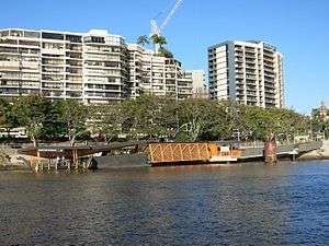
Maritime Museum ferry wharf
Maritime Museum | |||||||||||
|---|---|---|---|---|---|---|---|---|---|---|---|
 | |||||||||||
| Location | Lower River Terrace, South Brisbane | ||||||||||
| Coordinates | 27°28′55″S 153°01′42″E / 27.4819°S 153.0283°ECoordinates: 27°28′55″S 153°01′42″E / 27.4819°S 153.0283°E | ||||||||||
| Owned by | Brisbane City Council | ||||||||||
| Operated by | Transdev Brisbane Ferries | ||||||||||
| Platforms | 1 | ||||||||||
| Other information | |||||||||||
| Station code | 317578 | ||||||||||
| Fare zone | go card 1 | ||||||||||
| History | |||||||||||
| Previous names | River Plaza | ||||||||||
| Services | |||||||||||
| |||||||||||
Maritime Museum ferry wharf is located on the southern side of the Brisbane River serving the Brisbane suburb of South Brisbane. It is served by Transdev Brisbane Ferries' CityFerry services.[1][2] It was originally named River Plaza.
The wharf sustained major damage during the January 2011 Brisbane floods.[3] A new wharf was built opening on 31 July 2011, with the Maritime Museum name adopted after the adjacent Queensland Maritime Museum.[4][5]
References
- ↑ Maritime Museum wharf timetable TransLink
- ↑ CityFerry timetable Transdev Brisbane Ferries
- ↑ List: CityCat, CityFerry terminal damage Brisbane Times 20 January 2011
- ↑ Flood ravaged ferry stop to reopen on Monday Brisbane Times 28 July 2011
- ↑ CityCats and ferry services back in the swing The Courier Mail 31 July 2011
External links
![]() Media related to Maritime Museum ferry wharf at Wikimedia Commons
Media related to Maritime Museum ferry wharf at Wikimedia Commons
This article is issued from
Wikipedia.
The text is licensed under Creative Commons - Attribution - Sharealike.
Additional terms may apply for the media files.