River Đáy
| Hát Giang, sông Gián Khẩu | |
|---|---|
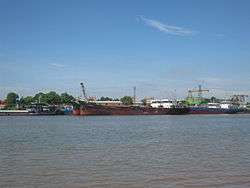 Day River through Ninh Phúc Port | |
| Country | Vietnam |
| Region | Hà Nội, Hòa Bình, Hà Nam, Ninh Bình and Nam Định |
| Basin features | |
| Main source |
Geladaindong Peak, Tanggula Mountains, Qinghai (Đan Phượng) 5,042 m (16,542 ft) |
| River mouth |
Đáy Mouth, Kim Sơn 0 m (0 ft) |
| Physical characteristics | |
| Length | 240 km (150 mi) |
The Day River (Vietnamese: Sông Đáy) is a river in Vietnam. It was formerly known as Sông Hát or Hát Giang. The river is a distributary of the Red River, draining into the Gulf of Tonkin.
The river has a length of 240 km[1] and has a drainage basin of more than 7,500 km²,[2] flowing through Hanoi, and the provinces of Hòa Bình, Hà Nam, Ninh Bình and Nam Định.
References
- ↑ http://www.rfa.org/vietnamese/in_depth/2007/04/28/VnpressReview_NNguyen/
- ↑ http://www.nea.gov.vn/Sukien_Noibat/Luuvuc_Song/tintuc.htm
This article is issued from
Wikipedia.
The text is licensed under Creative Commons - Attribution - Sharealike.
Additional terms may apply for the media files.