A2 motorway (Netherlands)
| ||||
|---|---|---|---|---|
| Rijksweg 2 | ||||
|
Motorways in the Netherlands with A2 and N2 bolt | ||||
| Route information | ||||
|
Part of | ||||
| Maintained by Rijkswaterstaat[1] | ||||
| Length: | 217.098 km[2] (134.898 mi) | |||
| Major junctions | ||||
| North end: |
| |||
| South end: |
| |||
| Location | ||||
| Provinces: | North Holland, Utrecht, Gelderland, North Brabant, Limburg | |||
| Highway system | ||||
| ||||

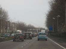
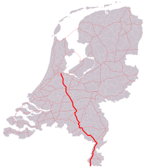
The A2 motorway is a motorway in the Netherlands. It is one of the busiest highways in the Netherlands. The road connects the city of Amsterdam, near the interchange Amstel, with the Belgian border, near Maastricht (NL) and Liège (B), and the Belgian road A25.
The route of the A2 motorway is shared with two major European routes. Between its start, at the Interchange Amstel near Amsterdam, and the Interchange Oudenrijn near Utrecht, the E35 follows the A2 motorway. From the Interchange Oudenrijn towards the Belgian border just south of Maastricht, the European route E25 follows the route of the A2. The local and express lane on A2 has different speed limit. The speed limit on express lane is 120 km/h (75 mph) and local is 100 km/h (63 mph).
Route description
Road N2
Currently, the motorway A2 is interrupted at one location, near Maastricht. This section is being referred to as N2, to make a distinction between the motorway (A2) and the non-motorway (N2).
The N2 through Maastricht
Between the interchanges Kruisdonk and Europaplein through Maastricht, the motorway A2 is interrupted. This road section was built as a highway with several at-grade intersections with traffic lights.
The N2 around Eindhoven
The beltway around the city of Eindhoven, the so-called Randweg between the interchanges Ekkersweijer and Leenderheide, uses a system of local-express lanes. The inner two lanes do not have any exits, so it is exclusively for express traffic passing the city of Eindhoven; it is considered a motorway (A2) with a maximum speed of 120 km/h (75 mph). The outer two lanes are used by vehicles to and from Eindhoven and the neighbouring towns. It does not meet the Dutch standards of a motorway (steeper grades near intersections and smaller bend radiuses), and has a maximum speed of 80 km/h (50 mph). These outer lanes have road number N2, to distinguish the local lanes from the express lanes.[3]
History
Other reconstruction projects
The A2 motorway was subject to multiple reconstruction projects. Next to the project around Eindhoven, as described above, the A2 was being rebuilt at the following locations:
Amsterdam - Utrecht
Between interchanges Holendrecht and Oudenrijn, the road has been widened from six (2x3) to ten (2x5) lanes. It has enough space to expand the road to fourteen (2x7) lanes. Near the city of Utrecht, a system of local-express lanes has been applied, with the inner three lanes serving express traffic, and the outer two lanes serving local traffic. Unlike the situation near Eindhoven, the motorway status is maintained for local lanes, which means that all ten lanes will keep the name A2.[4][5]
Utrecht - 's-Hertogenbosch
Between interchanges Oudenrijn and Everdingen, the A2 was expanded to 2x4 lanes. Between interchanges Everdingen and Deil, the road is widened from four (2x2) to eight lanes (2x4); the section between interchanges Deil and Empel was expanded from four to six lanes.[6]
's-Hertogenbosch beltway
The A2 around the city of 's-Hertogenbosch was rebuilt similarly to the future situation near Utrecht. However, there are only just four express lanes, instead of the six near Utrecht, so the road has 4x2 lanes.[7]
's-Hertogenbosch - Eindhoven
Since both the 's-Hertogenbosch and Eindhoven beltways were finished in 2009, a new bottleneck appeared between both cities. The motorway has only 2x2 lanes while both beltways are having twice the capacity. Construction of expanding this section to 2x3 lanes started on December 13, 2011. [8]
Future
A tunnel underneath the city of Maastricht is under construction, to eliminate at-grade intersections. It will have both local and express lanes.[9]
Exit list
| Country | Province | Municipality | km | mi | Exit | Name | Destinations | Notes |
|---|---|---|---|---|---|---|---|---|
| The Netherlands | North Holland | Amsterdam | 31 | 19 | — | Interchange Amstel | North end of E 35 overlap | |
| Ouder-Amstel | 33 | 21 | 1 | Oudekerk aan de Amstel | ||||
| Amsterdam | 35 | 22 | — | Holendrecht interchange | ||||
| 36 | 22 | 2 | Amsterdam-Zuidoost | Northbound exit and southbound entrance only | ||||
| Utrecht | Abcoude | 39 | 24 | 3 | Abcoude | |||
| De Ronde Venen | 44 | 27 | 4 | Vinkeveen | ||||
| Breukelen | 50 | 31 | 5 | Breukelen | ||||
| Utrecht | 57 | 35 | 6 | Maarssen | ||||
| 60 | 37 | 7 | Utrecht-Leidsche Rijn-Centrum | |||||
| 62 | 39 | 8 | Utrecht-Centrum | |||||
| 64 | 40 | — | Oudenrijn interchange | South end of E 35 overlap; north end of E 25 overlap | ||||
| Nieuwegein | 68 | 42 | 9 | Nieuwegein | ||||
| 71 | 44 | 10 | Nieuwegein-Zuid | |||||
| Vianen | 72 | 45 | 11 | Vianen | ||||
| 74 | 46 | — | Everdingen interchange | |||||
| 79 | 49 | 12 | Everdingen | |||||
| Gelderland | Culemborg | 81 | 50 | 13 | Culemborg | |||
| Geldermalsen | 85 | 53 | 14 | Beesd | ||||
| 88 | 55 | 15 | Geldermalsen | |||||
| 91 | 57 | — | Deil interchange | |||||
| Neerijnen | 94 | 58 | 16 | Waardenburg | Gap in km near Waalbrug | |||
| Zaltbommel | 102 | 63 | 17 | Zaltbommel | ||||
| Maasdriel | 107 | 66 | 19 | Kerkdriel | ||||
| North Brabant | 's-Hertogenbosch | 112 | 70 | — | Empel interchange | North end of A59 overlap | ||
| 113 | 70 | 20 | Rosmalen | |||||
| 115 | 71 | — | Hintham Interchange | South end of A59 overlap | ||||
| Veghel | 117 | 73 | 21 | Veghel | ||||
| Schijndel | 119 | 74 | 22 | Sint-Michielsgestel | ||||
| Vught | 120 | 75 | — | Vught interchange | Southbound exit and northbound entrance only | |||
| 121 | 75 | 23 | Tilburg | Northbound exit and southbound entrance only | ||||
| 123 | 76 | 24 | Vught | |||||
| Boxtel | 127 | 79 | 25 | Boxtel-Noord | ||||
| 132 | 82 | 26 | Boxtel | |||||
| Best | 138 | 86 | 27 | Best-West | ||||
| 141 | 88 | 28 | Best | |||||
| Eindhoven | 143– 12 | 89– 7.5 | — | Ekkersweijer interchange | Gap in km due to connection with A50 | |||
| 13– 154 | 8.1– 96 | — | Batadorp interchange | Gap in km due to connection with A58 | ||||
| 156 | 97 | 29 | Eindhoven-Airport | |||||
| 157 | 98 | 30 | Eindhoven-Centrum | Southbound exit and northbound entrance only | ||||
| 158 | 98 | 30a | Meerhoven-Zuid | |||||
| Veldhoven | 159 | 99 | 31 | Veldhoven | ||||
| 162 | 101 | 32 | Veldhoven-Zuid | |||||
| Eindhoven | 163– 19 | 101– 12 | — | De Hogt interchange | Gap in km due to connection with A67; west end of A67 and E 34 overlap | |||
| 20 | 12 | 32a | High Tech Campus | |||||
| 22 | 14 | 33 | Waalre | |||||
| 23– 170 | 14– 110 | — | Leenderheide interchange | Gap in km due to connection with A67; east end of A67 and E 34 overlap | ||||
| Valkenswaard | 176 | 109 | 34 | Valkenswaard | ||||
| Heeze-Leende | 178 | 111 | 35 | Leende | Northbound exit and southbound entrance only | |||
| Cranendonck | 183 | 114 | 36 | Maarheeze | ||||
| 185 | 115 | 37 | Budel | |||||
| Limburg | Weert | 189 | 117 | 38 | Weert-Noord | |||
| Nederweert | 194 | 121 | 39 | Nederweert | Gap in km | |||
| Leudal | 206 | 128 | 40 | Kelpen-Oler | ||||
| 213 | 132 | 41 | Grathem | |||||
| Maasgouw | 216 | 134 | 42 | Wessem | Northbound exit and southbound entrance only | |||
| 218 | 135 | 43 | Maasbracht | Southbound exit and northbound entrance only | ||||
| Echt-Susteren | 220 | 140 | 44 | Sint Joost | ||||
| 221 | 137 | — | Het Vonderen interchange | Northbound exit and southbound entrance | ||||
| 224 | 139 | 45 | Echt | |||||
| 228 | 142 | 46 | Roosteren | |||||
| Sittard-Geleen | 232 | 144 | 47 | Born | ||||
| Stein | 239 | 149 | 48 | Urmond | ||||
| 241 | 150 | — | Kerensheide interchange | |||||
| 243 | 151 | 49 | Elsloo | |||||
| Meerssen | 246 | 153 | 50 | Ulestraten | ||||
| 250 | 160 | 51 | Meerssen | Southbound exit and northbound entrance only | ||||
| Maastricht | 254 | 158 | 52 | Maastricht-Noord | Southbound entrance and exit only | |||
| 254 | 158 | — | Kruisdonk interchange | Northbound exit and southbound entrance only | ||||
| — | North end of A2 / N2 road designation | |||||||
| 258 | 160 | 53 | Maastricht-Centrum Noord | Southbound entrance still under construction | ||||
| 261 | 162 | 54 | Maastricht-Centrum Zuid | Northbound entrance and southbound exit still under construction | ||||
| — | South end of A2 / N2 road designation | |||||||
| 263 | 163 | 55 | Maastricht-Zuid | Southbound exit and northbound entrance only | ||||
| Eijsden | 265 | 165 | 56 | Gronsveld | ||||
| 268 | 167 | 57 | Oost-Maarland | Southbound exit and northbound entrance | ||||
| 270 | 170 | 58 | Eijsden | Northbound exit and southbound entrance only | ||||
| The Netherlands / Belgium country line | Limburg (NL) / Limburg (BE) province line | Eijsden / Voeren municipality line | — | Border with Belgium; this road continues as the Belgian A25; south end of E 25 overlap | ||||
1.000 mi = 1.609 km; 1.000 km = 0.621 mi
| ||||||||
References
| Wikimedia Commons has media related to Rijksweg 2. |
- ↑ "Wegbeheerders". Rijkswaterstaat. Retrieved 27 December 2016.
- ↑ "Actuele Wegenlijst Julie 2015" (PDF). Rijkswaterstaat. Retrieved 27 December 2016.
- ↑ A2: vernieuwing randweg Eindhoven, Rijkswaterstaat Archived June 10, 2008, at the Wayback Machine. (in Dutch)
- ↑ A2: verbreding knooppunt Holendrecht – aansluiting Maarssen, Rijkswaterstaat Archived April 20, 2008, at the Wayback Machine. (in Dutch)
- ↑ A2: verbreding Maarssen tot knooppunt Oudenrijn, Rijkswaterstaat Archived September 16, 2008, at the Wayback Machine. (in Dutch)
- ↑ A2: verbreding Everdingen - Deil, Rijkswaterstaat Archived April 20, 2008, at the Wayback Machine. (in Dutch)
- ↑ A2: Rondweg 's-Hertogenbosch, Rijkswaterstaat (in Dutch)
- ↑ infrasite.nl
- ↑ Unique stacked tunnel under Maastricht (archived) - Imtech Traffic & Infra

