Reventador
| Reventador | |
|---|---|
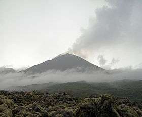
 Cone of Reventador in 2012 (V. Scherrer) | |
| Highest point | |
| Elevation | 3,562 m (11,686 ft) [1] |
| Coordinates | 0°4′39″S 77°39′21″W / 0.07750°S 77.65583°WCoordinates: 0°4′39″S 77°39′21″W / 0.07750°S 77.65583°W [1] |
| Naming | |
| Translation | the burster (Spanish) |
| Geography | |
 Reventador | |
| Parent range | Andes |
| Geology | |
| Mountain type | Stratovolcano (active) |
| Volcanic arc/belt | North Volcanic Zone |
| Last eruption | 2008 to 2017 (ongoing) |
Reventador is an active stratovolcano which lies in the eastern Andes of Ecuador. It lies in a remote area of the national park of the same name, which is Spanish for 'exploder' or 'ripper'. Since 1541 it has erupted over 25 times, although its isolated location means that many of its eruptions have gone unreported. Its most recent eruption began in 2008[2] and is ongoing as of July 4, 2017.[3] The largest historical eruption occurred in 2002.[2] During that eruption the plume from the volcano reached a height of 17 km and pyroclastic flows went up to 7 km from the cone.
On March 30, 2007, the mountain ejected ash again. The ash reached a height of about two miles (3 km, 11,000 ft). No injuries or damages have been reported.
The volcano's main peak lies inside a U-shaped caldera which is open towards the Amazon basin to the east. Its lavas are andesitic.
See also
References
- 1 2 "Reventador". Global Volcanism Program. Smithsonian Institution. Retrieved 2011-08-12.
- 1 2 "Reventador Eruption History - Global Volcanism Program". volcano.si.edu. Smithsonian. Retrieved 2017-08-07.
- ↑ "Reventador Weekly Reports - Global Volcanism Program". volcano.si.edu. Smithsonian. Retrieved 2017-08-07.
- http://www.igepn.edu.ec/vulcanologia/reventador/reventador.htm
- Photos of Reventador from August 2005
- Volcanic eruptions with little warning: the case of Volcán Reventador's Surprise November 3, 2002 Eruption, Ecuador
External links
 Media related to Reventador at Wikimedia Commons