Plauen
| Plauen | ||
|---|---|---|
|
Plauen and the city hall tower in the morning fog | ||
| ||
 Plauen | ||
Location of Plauen within Vogtlandkreis district  | ||
| Coordinates: 50°29′N 12°07′E / 50.483°N 12.117°ECoordinates: 50°29′N 12°07′E / 50.483°N 12.117°E | ||
| Country | Germany | |
| State | Saxony | |
| District | Vogtlandkreis | |
| Government | ||
| • Lord Mayor | Ralf Oberdorfer (FDP) | |
| Area | ||
| • Total | 102.12 km2 (39.43 sq mi) | |
| Elevation | 412 m (1,352 ft) | |
| Population (2015-12-31)[1] | ||
| • Total | 65,201 | |
| • Density | 640/km2 (1,700/sq mi) | |
| Time zone | CET/CEST (UTC+1/+2) | |
| Postal codes | 08523;-5;-7;-9 | |
| Dialling codes | 03741 | |
| Vehicle registration | V, AE, OVL, PL, RC | |
| Website | www.plauen.de | |
Plauen (German pronunciation: [ˈplaʊ̯ən])[2][3] is a town in the Free State of Saxony, east-central Germany.
It is the capital town of the district Vogtlandkreis. The town is situated near the border of Bavaria and the Czech Republic.
History
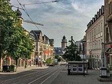


Plauen was founded by Polabian Slavs in the 12th century as "Plawe" and was passed to the Kingdom of Bohemia in 1327. The town was captured by the Archbishop of Magdeburg, Lippold von Bredow, in 1384. In 1466, it was passed to Albertine Saxony and later in 1569 to the Electorate of Saxony. Plauen became incorporated into the Kingdom of Saxony in 1806 during the Napoleonic Wars.
In the late-19th century, Plauen became a centre of textile manufacturing, specializing in Chemical lace, called Plauen lace. Around 1910, Plauen, as an industrial 'boomtown' of the region, reached its population peak (1910 census: 121,000, 1912: 128,000).
In the 1930s, Plauen hosted the first chapter of the Nazi Party outside of Bavaria. Plauen's population, however, has shrunk dramatically since the Second World War (1939: 111,000 inhabitants). It was occupied by American troops on 16 April 1945 but was left to Red Army on 1 July 1945.
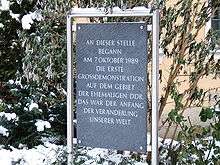
From 1945 onwards, Plauen fell into the Soviet occupation zone of Germany, which later became the German Democratic Republic (1949-1990). Plauen hosted a large Red Army occupation garrison and, in the last years of the GDR (DDR), an officer school of the Border Guards ("Grenztruppen der DDR"). The first mass demonstration against the communist regime in the GDR began in Plauen on 7 October 1989; this was the beginning of a series of mass demonstrations across the country and ultimately led to the re-unification of Germany in 1990.
The exposé Fast Food Nation gives special mention to Plauen as the first town of the GDR to have a McDonald's restaurant following the collapse of the Berlin Wall.
In the district reform of 1 July 2008, Plauen lost its urban district status and was merged into the district Vogtlandkreis.
Industry and infrastructure
Plauen (Vogtland) Oberer station lies on the Leipzig–Hof line. The section of this line through Plauen is part of the Saxon-Franconian trunk line running between Nürnberg, Hof, Plauen, Zwickau, Chemnitz and Dresden. The town had another station, Plauen (Vogtland) Unterer station (now defunct), on the Elster Valley Railway. There is a plan to rename the Oberer (Upper) station into Plauen Hauptbahnhof (Main Station).
Vogtlandbahn (Vogtland Railway), a regional train company, operates services from Plauen to Hof, Werdau, Chemnitz, Zwickau, Falkenstein and Adorf within Germany and Cheb (Eger) in the Czech Republic. At these stations, there are other Vogtlandbahn services to München, Regensburg, Marktredwitz, Dresden and Leipzig within Germany and Karlovy Vary (Karlsbad) and Prague in the Czech Republic. A Vogtlandbahn Express Bus service runs between Plauen and Berlin Schönefeld Airport and Zoological Garden.
The Plauen Straßenbahn is a tramway that has 6 lines connecting the centre of town, Plauen-Tunnel stop, to the surrounding areas and the Oberer railway station.
Main sights

- Embroidery Machine Museum
- Museum Plauener Spitze
- Galerie e.O. plauen
- Old Town Hall
- Elster Viaduct – second largest brick bridge in the world
- Friedensbrücke – largest stone arch bridge in the world
- Johanniskirche
- Old Elster Viaduct – oldest bridge in Saxony
- Malzhaus
Education and science
Plauen is home to a University of Applied Sciences with about 300 students and a DIPLOMA Fachhochschule.
Notable residents
- Heinrich von Plauen (1370–1429), Grand Master of the Teutonic Knights

- Christoph Pezel (1539–1604), theologian
- Johann von Mayr. (1716–1759). Prussian general
- Ferdinand Gotthelf Hand (1786–1851), philologist
- Eduard Friedrich Poeppig (1798–1868), botanist, zoologist and explorer
- Karl Brown (1807–1868), lawyer and politician, Chairman of the Central Ministry
- Gustav Hartenstein (1808–1890), philosopher
- Charles Beyer (1813–1876), locomotive designer and engineer
- Theodor Vogel (1836–1912), classic philologist,
- Emil Kautzsch (1841–1910), theologian
- Arwed Rossbach (1844–1902), architect in Leipzig
- Hermann Vogel (1854–1921), illustrator
- Paul Vogel (1856–1911), classical philologist, educator
- Kurt Helbig (1901–1975), weightlifter
- Friedrich Hielscher (1902–1990), religious philosopher, writer and resistance fighter against Nazism
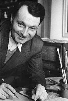
- E.O. Plauen (1903–1944), cartoonist
- Paul Wessel (1904–1967), politician (SED)
- Egon Zill (1906–1974), commander of the concentration camp Flossenburg

- Werner Hartenstein (1908–1943), war time commander of U-156, notable for the RMS Laconia (1921) incident
- Walter Ballhause (1911–1991), photographer
- Johannes Kuhn (born 1924), Protestant theologian
- Horst Dohlus (1925–2007), SED functionary
- Karl Richter (1926–1981), conductor, organist, and harpsichordist
- Hans Otte (1926–2007), composer and pianist
- Klaus Zink (born 1936), football player
- Richard Weber (born 1944), theater scholar
- Angelika Bahmann (born 1952), Olympic champion and world champion in canoe slalom
- Andrea Stolletz (born 1963), German handball goalkeeper
- Olaf Schubert (1967), comedian and musician
- Frank Meyer (born 1969), television presenter
- Christian Bahmann (born 1981), world champion in canoe slalom
- Christin Zenner (born 1991), swimmer
Twin cities
 Aš, Czech Republic, since 1962
 Steyr, Austria, since 1970
 Hof, Germany, since 1987
 Siegen, Germany, since 1990
 Cegléd, Hungary, since 2005
 Pabianice, Poland, since 2006
 Šiauliai, Lithuania, since 2010
Twin cities of Jößnitz (urban district)
 Heilsbronn, Germany
Former twin cities
References
- ↑ "Aktuelle Einwohnerzahlen nach Gemeinden 2015] (Einwohnerzahlen auf Grundlage des Zensus 2011)" (PDF). Statistisches Landesamt des Freistaates Sachsen (in German). July 2016.
- ↑ Krech, Eva-Maria; Stock, Eberhard; Hirschfeld, Ursula; Anders, Lutz Christian (2009). Deutsches Aussprachewörterbuch (in German). Berlin: Walter de Gruyter. p. 828. ISBN 978-3-11-018202-6.
- ↑ Mangold, Max (2005). Das Aussprachewörterbuch (in German) (6th ed.). Mannheim: Dudenverlag. p. 635. ISBN 9783411040667.
External links
-
 Plauen travel guide from Wikivoyage
 - Official website

