Raywell
Raywell is a hamlet in the East Riding of Yorkshire, England. It is situated approximately 7 miles (11 km) north-west of Hull city centre and 2 miles (3.2 km) north of Swanland.
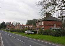
Raywell from the east
It is located on the crossroads of Westfields Road and Riplingham Road. These roads link Riplingham (South Cave), Eppleworth (Cottingham) and Kirk Ella.
Raywell forms part of the civil parish of Skidby.
It consists of a farm and an old manor house.
It is most noted as a local Scout/Girl guides site.[1] Locally it is also noted because a number of walks that start there.
References
- ↑ "Raywell Park". Humberside Scouts. Retrieved 14 August 2014.
- Gazetteer — A–Z of Towns Villages and Hamlets. East Riding of Yorkshire Council. 2006. p. 9.
| Wikimedia Commons has media related to Raywell. |
This article is issued from
Wikipedia.
The text is licensed under Creative Commons - Attribution - Sharealike.
Additional terms may apply for the media files.