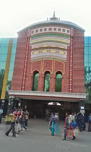
Rampurhat Junction railway station
Rampurhat Junction | |
|---|---|
| Indian Railway | |
 The front gate built as a eminent temple Tarapith | |
| Location |
Rampurhat, Birbhum district, West Bengal India |
| Coordinates | 24°10′45″N 87°46′55″E / 24.17917°N 87.78194°ECoordinates: 24°10′45″N 87°46′55″E / 24.17917°N 87.78194°E |
| Elevation | 37 metres (121 ft) |
| Owned by | Indian Railway |
| Operated by | Eastern Railway |
| Line(s) |
Sahibganj Loop Jasidih–Dumka–Rampurhat railway |
| Platforms | 3 |
| Tracks | 4 |
| Construction | |
| Structure type | At Ground |
| Parking | Available |
| Other information | |
| Status | Functional |
| Station code | RPH |
| Zone(s) | Eastern Railway |
| Division(s) | Howrah Division |
| Electrified | Yes |
Rampurhat railway station, station code RPH, is the railway station serving the city of Rampurhat in the Birbhum district in the Indian state of West Bengal.[1] Rampurhat Station is connected to Kolkata. Some express and passengers trains pass through the Rampurhat station. It is located at 24°06′N 87°28′E / 24.10°N 87.47°E.[2] It has an average elevation of 37 metres (121 ft). Nearest important railway junction is Sainthia Junction and Asansol Junction.
|
|
| Jasidih–Dumka–Rampurhat line | ||||||||||||||||||||||||||||||||||||||||||||||||||||||||||||||||||||||||||||||||||||||||||||||||||||||||||||||||||||||||||||||||||||||||||||||||||||||||||||||||||||||||||||||||||||||||||||||||||||||||||||||||||||||||||||||||||||||||||||||||||||||||||||||||||||||||||||||||||||||||||||||||||||||||||||||||||||||||||||||||||||||||||||||||||||||||||||||||||||||||||||||||||||||||||||||||||||||||||||||||
|---|---|---|---|---|---|---|---|---|---|---|---|---|---|---|---|---|---|---|---|---|---|---|---|---|---|---|---|---|---|---|---|---|---|---|---|---|---|---|---|---|---|---|---|---|---|---|---|---|---|---|---|---|---|---|---|---|---|---|---|---|---|---|---|---|---|---|---|---|---|---|---|---|---|---|---|---|---|---|---|---|---|---|---|---|---|---|---|---|---|---|---|---|---|---|---|---|---|---|---|---|---|---|---|---|---|---|---|---|---|---|---|---|---|---|---|---|---|---|---|---|---|---|---|---|---|---|---|---|---|---|---|---|---|---|---|---|---|---|---|---|---|---|---|---|---|---|---|---|---|---|---|---|---|---|---|---|---|---|---|---|---|---|---|---|---|---|---|---|---|---|---|---|---|---|---|---|---|---|---|---|---|---|---|---|---|---|---|---|---|---|---|---|---|---|---|---|---|---|---|---|---|---|---|---|---|---|---|---|---|---|---|---|---|---|---|---|---|---|---|---|---|---|---|---|---|---|---|---|---|---|---|---|---|---|---|---|---|---|---|---|---|---|---|---|---|---|---|---|---|---|---|---|---|---|---|---|---|---|---|---|---|---|---|---|---|---|---|---|---|---|---|---|---|---|---|---|---|---|---|---|---|---|---|---|---|---|---|---|---|---|---|---|---|---|---|---|---|---|---|---|---|---|---|---|---|---|---|---|---|---|---|---|---|---|---|---|---|---|---|---|---|---|---|---|---|---|---|---|---|---|---|---|---|---|---|---|---|---|---|---|---|---|---|---|---|---|---|---|---|---|---|---|---|---|---|---|---|---|---|---|---|---|---|---|---|---|---|---|---|---|---|---|---|---|---|---|---|---|---|---|---|---|---|---|---|---|---|---|---|---|---|---|---|---|---|---|---|---|---|---|
| ||||||||||||||||||||||||||||||||||||||||||||||||||||||||||||||||||||||||||||||||||||||||||||||||||||||||||||||||||||||||||||||||||||||||||||||||||||||||||||||||||||||||||||||||||||||||||||||||||||||||||||||||||||||||||||||||||||||||||||||||||||||||||||||||||||||||||||||||||||||||||||||||||||||||||||||||||||||||||||||||||||||||||||||||||||||||||||||||||||||||||||||||||||||||||||||||||||||||||||||||
| ||||||||||||||||||||||||||||||||||||||||||||||||||||||||||||||||||||||||||||||||||||||||||||||||||||||||||||||||||||||||||||||||||||||||||||||||||||||||||||||||||||||||||||||||||||||||||||||||||||||||||||||||||||||||||||||||||||||||||||||||||||||||||||||||||||||||||||||||||||||||||||||||||||||||||||||||||||||||||||||||||||||||||||||||||||||||||||||||||||||||||||||||||||||||||||||||||||||||||||||||
Further extension
The track from Dumka to Rampurhat is just completed. It has become operational in June 2015. The distance between Jasidih and Rampurhat is reduced by 140 km, from previous about 270 km via Asansol.
Facilities
The major facilities available are Waiting rooms, computerized reservation facility, Reservation Counter, 2 Wheeler Vehicle parking.[3] The vehicles are allowed to enter the station premises. The station also has STD/ISD/PCO Telephone Booth, ATM Counter, Toilets, Tea Stall and Book Stall.[4]
Platforms
Rampurhat station has 3 platforms and 2 more proposed. It is a standard on ground structure with roof. The platforms have to foot-over bridges.
Nearest airports
The nearest airports to Rampurhat Station are:[5]
- Netaji Subhash Chandra Bose International Airport, Kolkata 205 kilometres (127 mi)
- Birsa Munda Airport, Ranchi 299 kilometres (186 mi)
- Gaya Airport 328 kilometres (204 mi)
- Lok Nayak Jayaprakash Airport, Patna
See also
References
- ↑ Official website of the Birbhum district
- ↑ Falling Rain Genomics, Inc – Rampurhat
- ↑ "List of Locations (Irrespective Of States) Where Computerized Reservation Facilities Are Available". Official website of the Indian Railways. Archived from the original on 3 July 2013. Retrieved 18 April 2012.
- ↑ "Major passenger amenities available in stations over Asansol Division". Commercial Information. Official Website of the Eastern Railway. Retrieved 1 April 2012.
- ↑ "Rampurhat Railway Station". onefivenine.com. Retrieved 31 March 2012.