Rambuteau (Paris Métro)
| Paris Métro station | |||||||||||
 | |||||||||||
| Location |
4th arrondissement of Paris Île-de-France France | ||||||||||
| Coordinates | 48°51′40″N 2°21′12″E / 48.86119°N 2.35343°ECoordinates: 48°51′40″N 2°21′12″E / 48.86119°N 2.35343°E | ||||||||||
| Owned by | RATP | ||||||||||
| Operated by | RATP | ||||||||||
| Other information | |||||||||||
| Fare zone | 1 | ||||||||||
| History | |||||||||||
| Opened | 28 April 1935 | ||||||||||
| Services | |||||||||||
| |||||||||||
| Location | |||||||||||
 Rambuteau Location within Paris | |||||||||||
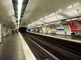
Rambuteau is a station on line 11 of the Paris Métro in the 3rd and 4th arrondissements in central Paris.
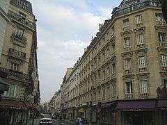
The station opened as part of the original section of the line from Châtelet to Porte des Lilas on 28 April 1935. It is named after the Rue Rambuteau, which was named after Claude-Philibert Barthelot, Comte de Rambuteau (1781 - 1869), a senior official in the former Départment of the Seine, who established the groundwork for the fundamental transformation of Paris that Haussmann carried out under the Second Empire.
Nearby are the Centre Georges Pompidou containing the Musée National d'Art Moderne, the Musée d'Art et d'Histoire du Judaïsme (museum of Jewish art and history) and the Jardin Anne-Frank (garden honouring Anne Frank).
Station layout
| G | Street Level | Exit/Entrance |
| B1 | Mezzanine | to Exits/Entrances |
| B2 | ||
| Southbound | ← | |
| Northbound | | |
Gallery
 Rue Rambuteau
 Street-level entrance at Rambuteau
 Line 11 platforms at Rambuteau
This article is issued from
Wikipedia.
The text is licensed under Creative Commons - Attribution - Sharealike.
Additional terms may apply for the media files.