Raipur, Punjab
| Raipur ਰਾਇਪੁਰ Rai bhukhar | |
|---|---|
| village | |
|
New building of the Gurudwara Sahib | |
| Coordinates: 29°54′20″N 75°15′17″E / 29.9055°N 75.2547°ECoordinates: 29°54′20″N 75°15′17″E / 29.9055°N 75.2547°E | |
| Country |
|
| State | Punjab |
| District | Mansa |
| Talukas | Sardulgarh |
| Elevation | 212 m (696 ft) |
| Population (2001) | |
| • Total | 5,530 |
| Languages | |
| • Official | Punjabi (Gurmukhi) |
| • Regional | Punjabi |
| Time zone | IST (UTC+5:30) |
| PIN | 151505[1] |
| Telephone code | 01659-268*** |
| Nearest city | Mansa |
| Sex ratio | 1000/880 ♂/♀ |
| Avg. summer temperature | 43 °C (109 °F) |
| Avg. winter temperature | 06 °C (43 °F) |
Raipur, located in the Sardulgarh tehsil of Mansa district[2][3][4] in Punjab, India, is an old and noted village of the area as the famous Babbar martyr Bhai Gurmel Singh of the village got martyrdom during an operation in Maujia on September 8, 1991
Geography
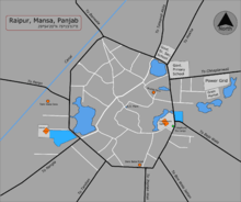
Raipur, having an average elevation of 212 metres (696 ft),[5] is approximately centered at 29°54′20″N 75°15′17″E / 29.90556°N 75.25472°E.[6] It's located in the development block of Jhunir in Mansa district of Indian Punjab. The city of Mansa lies to its northeast (21 km), the city and district of Bathinda to its northwest, Sardulgarh to its south (32 km) and the state capital city of Chandigarh to its far northeast (203 km). The historical city of Talwandi Sabo is just 21 km away in the northwest. It is linked directly to the 11 surrounding villages, Baje Wala, Bire Wala Jattan, Jherian Wali (Bishanpura), Tandian, Nangla, Peron, Behniwal, Bana Wala, Talwandi Aklia (Chhoti Talwandi), Makha and Chhapian Wali.[2]
Demographics
In 2001, as of census, the village had the total population of 5,530 with 940 households, 2,940 males and 2,590 females.[7] Thus males constitute 53% and females 47% of the total population with a sex ratio of 880 females per thousand males.
Culture
Punjabi is the mother tongue as well as the official language of the village, predominated by the Jatt people of Sidhu clan.
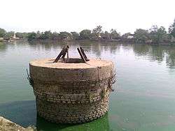
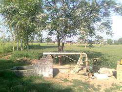
The well was used in the past but now it's unused for a long time and near to be ruined.
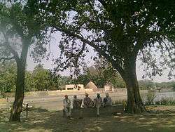
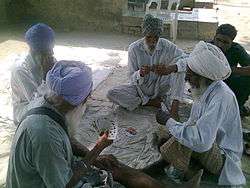
Men use to pass their free time by sitting together in the satth (English: a common place) or playing cards.
Religion
As of religion, the village is predominated by the Sikhs, the followers of Sikhism with Hindu and Muslim minorities.
The Gurudwara Sahib is the main religious site for all. There are three Deras, following the Sikh faith, in the memory of/founded by the respected Sants, known as Wadda Dera, Tahli Wala Dera and Dera Baba Preet. The village, further, has a lali Mandir now known as Durga Mandir, located near the water works as the worship site for Hindus. There is a burial place for the Muslim families.

Climate
The western Himalayas in the north, Thar Desert in the southwest and Monsoon mainly determines the climate. The temperature reach up to 43 °C (109 °F) in summer and 5 °C (41 °F) in winter. Monsoon greatly effects the agriculture in the region as nearly 70% of the rain falls in July–September by the Monsoon
Education

The village has good educational options, having a pioneer Institution of Secondary education Adarsh Public Senior Secondary School, Govt. Primary School, a Govt. Senior Secondary School,[8][9]
Economy
The village have a branch of the State Bank of India[10][11] located near the government primary school.
Agriculture
As common in the region, agriculture is the main occupation as well as the main source of income for all Jatts. There is a very good irrigation water supply from the canal and
when due to reasons the canal dries up, people used to run their tube wells as the second option. Wheat, Mustard and Cotton[12] are the main crops in the area.
Other
In the minorities, Hindus, have their shops, general and medical stores etc. and others do labour in the fields or are employed to the new, constructed having capacity about 2700 MW, Talwandi Sabo Power Plant on the outskirts.
Others
The village, further, has a power grid, water works and R.O. plant[13] for filtered water service and an animal dispensary.
Problems
- Education
There is a lack of teachers to teach over 800 students in the government schools.[8]
- Drainage
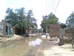
The Phirni (English: Surrounding road) of the village facing bad drainage problem as it is at lower water level than the houses so the daily wastage and rainy water floods it. The students also face problems going to school as near the schools the problem is at its worst. Rest of phirni (road) is not in good condition too.All roads of village leads to Mansa and Talwandi Sabo have been broken.
See also
References
- ↑ "Raipur, Mansa - PIN code". OneFiveNine.com. Retrieved January 7, 2012.
- 1 2 "SAD launches poll campaign Number of booths increased". The Tribune. May 8, 2008. Retrieved June 20, 2012.
- ↑ "ਕਿਸਾਨਾਂ ਦੇ ਘਰੋਂ ਸਿੱਧੀ ਕਣਕ ਭਰਦੇ ਆੜ੍ਹਤੀਏ ਕਾਬੂ, 1550 ਕਣਕ ਦਾ ਗੱਟ ਕੀਤਾ ਜਬਤ". PunjabNewsline. May 6, 2012. Retrieved June 20, 2012.
- ↑ "ਬੀਟੀ ਕਾਟਨ ਦਾ ਬੀਜ ਵੇਚਣ ਵਾਲੀਆਂ ਫਰਮਾਂ ਦੀਆਂ ਬਿਲ ਬੁੱਕਾਂ ਦੀ ਪੜਤਾਲ". Punjabi Tribune. May 27, 2012. Retrieved June 20, 2012.
- ↑ Falling Rain Genomics Inc. "Maps, Weather and Airports for Raipur, Punjab". Falling Rain Inc. Retrieved January 7, 2012.
- ↑ Google Maps
- ↑ "Raipur - 2001 census data (Sr. No. 61)". Government of India. 2001. Retrieved January 7, 2012.
- 1 2 "ਸਰਕਾਰੀ ਸਕੂਲਾਂ 'ਚ ਅਧਿਆਪਕਾਂ ਦੀਆਂ ਸੈਂਕੜੇ ਅਸਾਮੀਆਂ ਖ਼ਾਲੀ". Daily Ajit]. May 30, 2012. Retrieved June 22, 2012.
- ↑ "ਆਦਰਸ਼ ਸਕੂਲ ਰਾਏਪੁਰ ਦੀ ਜ਼ਿਲ੍ਹਾ ਪੱਧਰੀ ਖੇਡਾਂ ’ਚ ਚੜ੍ਹਤ Adarsh Public Senior Secondary School". Punjabi Tribune. September 2, 2011. Retrieved June 21, 2012.
- ↑ "ਸਕੂਲ ਨੂੰ ਆਰ. ਓ. ਸਿਸਟਮ ਦਿੱਤਾ". News in Punjabi. Daily Ajit. May 20, 2012. Retrieved June 27, 2012.
- ↑ "State Bank of India, Raipur Branch, Mansa, Punjab". Bank IFSC Code.com. Retrieved January 7, 2012.
- ↑ "ਭਰਵੀਂ ਬਾਰਿਸ਼ ਕਾਰਨ ਨਰਮੇ ਤੇ ਝੋਨੇ ਦਾ ਭਾਰੀ ਨੁਕਸਾਨ". News in Punjabi. Daily Ajit. September 16, 2011. Retrieved June 27, 2012.
- ↑ "200 Reverse Osmosis plants of little use". The Tribune. April 13, 2009. Retrieved January 10, 2012.

