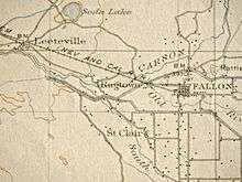
Ragtown, Nevada
| Ragtown | |
|---|---|
 Location of Ragtown in Nevada | |
| Coordinates | 39°30′14″N 118°55′01″W / 39.50389°N 118.91694°WCoordinates: 39°30′14″N 118°55′01″W / 39.50389°N 118.91694°W |
| Reference no. | 19[3] |
Ragtown, Nevada, is a Churchill County ghost town of an abandoned 1854 trading post west of Fallon.[4]
History
Twelve miles northwest of Fallon exhausted immigrants in 1854 recuperated alongside the Carson River after a trip across the Forty Mile Desert. The station was named because of the many rags cast off by the travelers. The tattered garments after being washed were hung in the bushes to dry. In 1855, Jules Remey and Julius Brenchley stated that it consists of "three huts, formed by poles covered with rotten canvas full of holes."[5]
The Ragtown post office was active from May 14, 1864 to May 29, 1867 and from May 5, 1884 to April 19, 1887.[5]

Leeteville was a post office that existed from January 28, 1895 to June 12, 1907 named for James Leete. Esther M Leete was the first postmistress.[5]:154

References
- ↑ McBride, Dennis; Dunar, Andrew J (2001). Building Hoover Dam: An Oral History of the Great Depression. p. 40. ISBN 0-87417-489-9. Retrieved 2010-05-25.
- ↑ Vintage Photograph Collection - Children, Hoover Dam Museum, Boulder City
- ↑ "Nevada Historical Markers". Nevada State Historic Preservation Office. Retrieved 24 February 2013.
- ↑ Nevada State Historic Preservation - historical markers
- 1 2 3 4 Carlson, Helen S. (1985). Nevada place names : a geographical dictionary. Reno: University of Nevada Press. pp. 154, 197. ISBN 0-87417-094-X.
