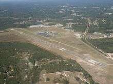
Richmond County Airport
| Richmond County Airport | |||||||||||||||
|---|---|---|---|---|---|---|---|---|---|---|---|---|---|---|---|
 | |||||||||||||||
| Summary | |||||||||||||||
| Airport type | Public | ||||||||||||||
| Owner | Richmond County | ||||||||||||||
| Serves | Rockingham, North Carolina | ||||||||||||||
| Elevation AMSL | 358 ft / 109.1 m | ||||||||||||||
| Coordinates | 34°53′29″N 79°45′35″W / 34.89139°N 79.75972°WCoordinates: 34°53′29″N 79°45′35″W / 34.89139°N 79.75972°W | ||||||||||||||
| Runways | |||||||||||||||
| |||||||||||||||
Richmond County Airport (ICAO: KRCZ, FAA LID: RCZ), formerly known as Rockingham-Hamlet Airport, is a public airport located in and operated by Richmond County, North Carolina. It is situated three miles (5 km) south of the city of Rockingham and west of the city of Hamlet. The airport is used entirely for general aviation and has undergone major renovations and expansion in recent years.
Terminal at Richmond County Airport
Facilities
Richmond County Airport covers 316 acres (128 ha) and has two runways:
- Runway 4/22: 3,000 x 500 ft. (914 x 152 m), Surface: Turf
- Runway 14/32: 5,000 x 100 ft. (1,524 x 30 m), Surface: Asphalt
References
- ↑ FAA Airport Master Record for RCZ (Form 5010 PDF)
- ↑ Richmond County Airport, official site
External links
- "Richmond County Airport - RCZ" (PDF). at North Carolina DOT airport guide
- FAA Terminal Procedures for RCZ, effective August 17, 2017
- Resources for this airport:
- FAA airport information for RCZ
- AirNav airport information for KRCZ
- FlightAware airport information and live flight tracker
- NOAA/NWS latest weather observations
- SkyVector aeronautical chart, Terminal Procedures
This article is issued from
Wikipedia.
The text is licensed under Creative Commons - Attribution - Sharealike.
Additional terms may apply for the media files.