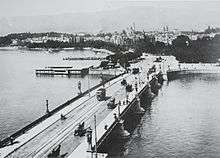
Quaibrücke, Zürich
| Quay Bridge Quaibrücke | |
|---|---|
 Quaibrücke | |
| Coordinates | 47°22′01″N 8°32′35″E / 47.36694°N 8.54306°ECoordinates: 47°22′01″N 8°32′35″E / 47.36694°N 8.54306°E |
| Carries | Two tram tracks, and on each side two lanes for road traffic, bicycles, and pedestrian sidewalks |
| Crosses | Limmat, the outflow of Lake Zurich |
| Locale | Zürich, Switzerland |
| Official name | Quaibrücke |
| ID number | 1560 |
| Followed by | Münsterbrücke |
| Characteristics | |
| Material | Steel |
| Width | 30.5 m (100 ft) |
| Longest span | 121.9 m (400 ft) |
| No. of spans | 4 |
| History | |
| Engineering design by | Arnold Bürkli |
| Construction start | 1880 |
| Construction end | 1884 |
| Opened | 1 January 1885, 18 March 1984 |
| Rebuilt | 1932, 1939 (widening to 28.5m), 1983-1984 (total rebuild and widening to 30.5m), 2015 (refurbishment) |
Quaibrücke (English: Quay Bridge) is a road, tramway, pedestrian and bicycle bridge over the river Limmat, at the outflow of Lake Zürich in the city of Zürich, Switzerland. It was built simultaneously with the construction of Zürich's new quays between 1881 and 1887.[1]
Geography
Quaibrücke is situated at the outflow of Lake Zürich and connects the Bürkliplatz with the Bellevueplatz, and hence the lake's left (or western) shore with the right (or eastern) shore. It is a nodal point of the Tram lines 2, 5, 8, 9 and 11, as well of the road traffic between General-Guisan-Quai, and Utoquai.
History

The Quaibrücke was erected between 1880 and 1884 under the management of Arnold Bürkli (1833–1894), the city engineer at the time.[1] A modern land connection was urgently needed after an intense political campaign.
On May 18, 1873, the municipal council (the legislature) approved the construction of the Quay Bridge with a strong majority vote.
The bridge was built together with the municipalities of Enge (left, west shore), Riesbach (right, east shore), and Zurich. It was also built simultaneously with the Utoquai and General-Guisan-Quai on the two shores of Lake Zurich, but was finished half a year earlier. Since the bridge disabled the traffic on the Limmat, the landing gate of the ZSG Zürichsee-Schifffahrtsgesellschaft had to be moved from the Bauschänzli island to the present Bürkliterrasse.
As part of the Zürich lakefront, two machine-gun bunkers were built in the 1940s, which are still preserved at their original sites at Limmatquai and Bürkliterrasse.[2] The original construction had to be replaced in 1984 and a new bridge was built parallel to the old bridge between 1983 and 1984, on steel girders. The weekend of March 16/17, 1984, traffic was blocked and the old construction was moved on steel beams and columns in the lake. Initiatives to redesign the old bridge as a pedestrian zone were rejected.[3]
Between April and November 2015 further refurbishment work was applied.[4]
References
- 1 2 Ernst Tschannen (May 2006). "Vom Bürkliplatz zur Sukkulenten-Sammlung" (PDF) (in German). Zurich, Switzerland: Grün Stadt Zürich. Retrieved 2015-01-05.
- ↑ Tina Fassbind (May 2006). "Gefechtsstand Quaibrücke". Tages-Anzeiger (in German). Zurich, Switzerland. Retrieved 2015-01-05.
- ↑ Gebrüder Dürst. "Der Bürkliplatz" (in German). gebrueder-duerst.ch. Retrieved 2015-01-05.
- ↑ "Sanierungsarbeiten Bellevue und Quaibrücke 2015" (in German). Tiefbauamt Stadt Zürich. 2014-12-02. Archived from the original on January 5, 2015. Retrieved 2015-01-06.
External links
-
 Media related to Quaibrücke Zürich at Wikimedia Commons
