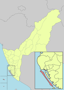
Qijin District, Kaohsiung
| Cijin 旗津區 Qijin | |
|---|---|
| District | |
| Cijin District[1] | |
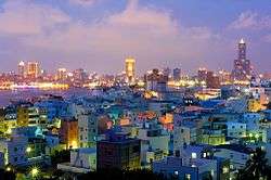 | |
 Cijin District in Kaohsiung City | |
| Country | Taiwan |
| Region | Southern Taiwan |
| Population (January 2016) | |
| • Total | 28,992 |
| Website | Official Website (in Chinese) |

Cijin District (Chinese: 旗津區; Hanyu Pinyin: Qíjīn Qū; Tongyong Pinyin: Cíjin Cyu; Wade–Giles: Ch'i2-chin1 Ch'ü1; Pe̍h-ōe-jī: Kî-tin-khu) is a district of Kaohsiung City, Taiwan, covering Cijin Island. It is the second smallest district in Kaohsiung City after Yancheng District.
History
Cijin forms the original core of the Kaohsiung, which was established by the fisherman Hsu Ah-hua (徐阿華) in the mid-17th century. He realized the attractiveness of the location when he was forced to seek shelter from a typhoon in the Taiwan Strait and returned with settlers from the Hung, Wang, Cai, Li, Bai, and Pan families and an idol of the Chinese sea goddess Mazu. This was housed in a bamboo and thatch structure that formed the first Chi Jin Mazu Temple. The town grew up around the temple grounds.[2]
Cijin Island was once connected to the mainland at the southern tip, but in 1967, this link was severed to create a second entry point to the Port of Kaohsiung.
Geography
Two islands and one reef in the South China Sea are administered by Kaohsiung City as parts of Cijin District:
- Pratas Islands (aka Dongsha Islands)
- Taiping Island
- Zhongzhou Reef
Government
The representative for Qijin on the city council is Lee Chiao-Ju.[3]
Economy
Most of its residents are employed by the shipping industry. There is a park on the north western shore.
Tourist attractions
- Chi Jin Mazu Temple
- Cijin Shell Museum
- Cijin Wind Turbine Park
- Kaohsiung Lighthouse
- Qihou Fort
- Rainbow Church
- War and Peace Memorial Park and Theme Hall
- YM Museum of Marine Exploration Kaohsiung
Transportation

The "Cross Harbor Tunnel" (Chinese: 過港隧道) connects Qijin Island at the EBC tip to the rest of Kaohsiung on mainland Taiwan. Qijin District is also accessible by two ferry piers, the Qijin Ferry Pier at the northern tip of the island and the Zhongzhou Ferry Pier at the middle of the island.
References
- ↑ "Administrative Districts". 高雄市政府. 30 September 2016. Retrieved 4 April 2017.
- ↑ "Tianhou Temple at Cihou", Official site, Kaohsiung: Bureau of Cultural Affairs of the Kaohsiung City Government, 2008. (in Chinese) & (in English)
- ↑ "4.Members Introduction: Lee, Chiao-Ju". Kaohsiung City Council. Retrieved 22 February 2017.
External links
| Wikimedia Commons has media related to Cijin District, Kaohsiung. |
Districts of Kaohsiung | ||
|---|---|---|
| Urban area | .svg.png) | |
| Fongshan region | ||
| Gangshan region | ||
| Cishan region | ||
| Mountain indigenous districts | ||
Note: Although Hanyu Pinyin is the national standard, the Kaohsiung Government names its districts based on Tongyong Pinyin. | ||
| Kaohsiung |  | |
|---|---|---|
| Kinmen | ||
| Lienchiang1 | ||
| Penghu | ||
| Pingtung | ||
| Taitung | ||
| Yilan | ||
1 Lienchiang County commonly known as Matsu. 2Diaoyutai Islands are controlled by Japan, (called Senkaku Islands). 3Seat of the outlying islands' counties | ||
Coordinates: 22°33′42″N 120°18′25″E / 22.561674°N 120.306998°E
- ↑ "Administrative Districts". 高雄市政府. 30 September 2016. Retrieved 4 April 2017.