Qieding District, Kaohsiung
| Cieding 茄萣區 Qieding | |
|---|---|
| District | |
| Cieding District[1] | |
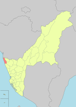 Qieding District in Kaohsiung City | |
| Country | Taiwan |
| Region | Southern Taiwan |
| Population (January 2016) | |
| • Total | 30,498 |
| Website | Official Website (in Chinese) |
Cieding District[2] (Chinese: 茄萣區; Hanyu Pinyin: Qiédìng Qū; Tongyong Pinyin: Ciédìng Cyu; Pe̍h-ōe-jī: Ka-tiāⁿ-khu) is a coastal suburban district in Kaohsiung, Taiwan.
Name and pronunciation
Etymology
One theory is that it is named for a type of local mangrove. Another is that it derived from a Makattao aboriginal name, written as "Cattia" or "Cattea" by Europeans, meaning "place of many fish" (literally "ten fish"). This was then rendered as Ka-tang-tiāⁿ-á (茄苳萣仔)[3] and Ka-tiāⁿ-á (茄萣仔) in Taiwanese Hokkien and also Ka-tiāⁿ (茄萣) or Ka-têng (茄藤) with both sets of characters also referring to types of Avicennia (cf. 海茄苳 Avicennia marina, 海茄朾).
Pronunciation and Romanization
Traditionally, the name is pronounced Ka-tiāⁿ in Taiwanese and Jīadìng in Mandarin. Following the 1945 handover of Taiwan, the name was romanized as Chiating via the Wade-Giles system. The later systems MPS II and Tongyong Pinyin yielded Jiading, which is seen on street signs and signs on the district office and the local elementary and junior high schools.
However outside of Jiading, the pronunciation of Qiédìng in Mandarin is common, using an alternate reading of the first Chinese character in the name (Chinese: 茄; pinyin: jiā; Pe̍h-ōe-jī: kiô). With the adoption of Hanyu Pinyin for Taiwanese place names in 2009, the name was officially rendered as Qieding by the Ministry of the Interior, but has not achieved uniform implementation. Buses from Kaohsiung and Tainan have the name Romanized with the non-standard "Chieding". The district's website uses several non-standard spellings including "Cieding",[4] "Cheting",[5] and "Chieting".[6]
History
From 1920 to 1945, the district was governed under Konai village (湖内庄), Okayama District, Takao Prefecture.
Administrative divisions

- Baiyun Village (白雲里 Mandarin: Báiyún Lǐ; Taiwanese: Pe̍h-hûn Lí)
- Baoding Village (保定里 Bǎodìng Lǐ; Pó-tiāⁿ Lí)
- Dading Village (大定里 Dàdìng Lǐ; Tāi-tiāⁿ Lí)
- Fude Village (福德里 Fúdé Lǐ; Hok-tek Lí)
- Guangding Village (光定里 Guāngdìng Lǐ; Kong-tiāⁿ Lí)
- Hexie Village (和協里 Héxié Lǐ; Hô-hia̍p Lí)
- Jia'an Village (嘉安里 Jiā'ān Lǐ; Ka-an Lí)
- Jiaci Village (嘉賜里 Jiācì Lǐ; Ka-sù Lí)
- Jiading Village (嘉定里 Jiādìng Lǐ; Ka-tiāⁿ Lí)
- Jiafu Village (嘉福里 Jiāfú Lǐ; Ka-hok Lí)
- Jiale Village (嘉樂里 Jiālè Lǐ; Ka-lo̍k Lí)
- Jiatai Village (嘉泰里 Jiātài Lǐ; Ka-thài Lí)
- Jiding Village (吉定里 Jídìng Lǐ; Kiat-tiāⁿ Lí)
- Qilou Village (崎漏里 Qílòu Lǐ; Kiā-làu Lí)
- Wanfu Village (萬福里 Wànfú Lǐ; Bān-hok Lí)[7]
Infrastructure
Tourist attractions
- Jiading Wetlands
- Lovers Wharf
- Tourist Fish Market
- Kuo Chang-hsi Knife and Sword Museum[8][9]
Notable natives
- Lin Yi-shih, Secretary-General of Executive Yuan (2012)
- Wang Yu-yun, Mayor of Kaohsiung (1973-1981)
See also
| Wikimedia Commons has media related to Chieding District, Kaohsiung. |
References
- ↑ "Welcome to Cieding District Office". 茄萣區公所(英文網). Retrieved 4 April 2017.
- ↑ "Welcome to Cieding District Office". 茄萣區公所(英文網). Retrieved 4 April 2017.
- ↑ "Entry #40140 (茄苳萣仔)". 臺灣閩南語常用詞辭典 [Dictionary of Frequently-Used Taiwan Minnan] (in Chinese and Hokkien). Ministry of Education, R.O.C. 2011.
- ↑ 高雄市茄萣區公所
- ↑ Cheting District Office, Kaohsiung City
- ↑ Cheting District Office, Kaohsiung City
- ↑ http://cheting-en.kcg.gov.tw/cheting-en/CP.aspx?s=2741&cp=1&n=12818
- ↑ http://heritage.khcc.gov.tw/english/Heritage.aspx?KeyID=099cb598-1f70-45e7-b8f6-3b2046e2e60d
- ↑ https://www.youtube.com/watch?v=aEEbzx81MuA
External links
- Cieding District Office, Kaohsiung City
- https://web.archive.org/web/20120325205328/http://placesearch.moi.gov.tw/translate/Admin1000616.pdf
Districts of Kaohsiung | ||
|---|---|---|
| Urban area | .svg.png) | |
| Fongshan region | ||
| Gangshan region | ||
| Cishan region | ||
| Mountain indigenous districts | ||
Note: Although Hanyu Pinyin is the national standard, the Kaohsiung Government names its districts based on Tongyong Pinyin. | ||
Coordinates: 22°54′24.43″N 120°10′57.37″E / 22.9067861°N 120.1826028°E
- ↑ "Administrative Districts". 高雄市政府. 30 September 2016. Retrieved 4 April 2017.