Purangi
| Purangi | |
|---|---|
 Purangi | |
| Coordinates: 39°9′15″S 174°31′51″E / 39.15417°S 174.53083°E | |
| Country | New Zealand |
| Region | Taranaki |
| District | New Plymouth District |
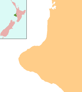
Purangi is a locality east of Inglewood, New Zealand, situated on the banks of the Waitara River. It is the location of the central marae for the Ngāti Maru iwi.
The Bell at Purangi - 1850s
The locality of Purangi, includes the sites of three Maori kainga; Pukemahoe, Purangi and Te Pokuru Pa. The first two were on the banks of the Waitara River, about a mile and a half apart. Te Pokuru Pa was six or seven miles from Pukemahoe. The story of the bell begins with Rev. Richard Taylor, Missionary of the Whanganui district. He placed the charge of the bell with Himiona Te Kapiti, a Maori layreader. At the time, Himiona lived on the upper reaches of the Whanganui river and was mainly responsible for the extension of Christianity in those districts. From Himiona the bell passed into the hands of Te Manihera Te Ikahaehae, also a layreader, of the Ngāti Maru.
The bell was first used at Te Pokuru Pa, but the Pa was later deserted. During the 1850s, Ngati Maru erected an Anglican church at Pukemahoe, and so the bell was carried there. Once the bell was fixed in its place, Ngati Maru brought Archdeacon Govett (1819-1903) to open the church. There was much festivities on his arrival, for at the time he was the first white missionary who had ever gone into that part of the country. The chief of Purangi was Tutanuku Tume, elder brother of Te Manihera Tume. Both men were the nephews of Te Manihera Te Ikahaehae referred to above.
When the Anglo-Maori wars broke out in 1860, Titokowaru (a Hauhau chief and freedom fighter against the Pakeha) desecrated the church. He tore up the floor and converted the church into a Wharenui (Maori meeting house). The occupants of Purangi aligned themselves with Titokowaru and joined the Hauhau Movement, turning away from the Anglican faith.
Te Haina'Uira'Wehikore, Manihera's Sister took charge of the bell, and kept it in her care. In 1888, she met with Mr W.H.Skinner at Purangi and asked him to accept the bell back. She had two bells, a large one from the Anglican Church, and a smaller one from the Roman Catholic Mission at Ngakorako. Mr Skinner accepted both bells, and returned the Roman Catholic bell to the priest in charge of New Plymouth and the Anglican bell to St Mary's parish. This bell was attached to St Marys Schoolroom, and it was still there at the turn of the 20th century.[1]
Purangi Landless Natives Act 1907
Large areas of land were confiscated in Taranaki under the New Zealand Settlements Act 1863 and its subsequent amendments. This rendered many Maori landless. In 1907, the Crown passed legislation that allowed for the landless Maori at Purangi to be provided with enough land each to support themselves. This legislation was called the Purangi Landless Natives Act 1907.
The First Schedule of the Act, listed the Maori who were entitled to receive land under this legislation. They were Tutanuku Tume, Te Ika Haehae, Kapohanga Wehikore, Uira Wehikore and 15 others. Te Ikahaehae in this schedule was also known as Te Manihera Te Ikahaehae.
Sources
1. Taranaki Herald, Volume L, Issue 12448, 30 December 1903, Page 6
2. http://nzetc.victoria.ac.nz/tm/scholarly/tei-Gov1907Acts-t1-g1-t7-body1-d2.html
References
- ↑ Taranaki Herald, Volume L, Issue 12448, 30 December 1903, Page 6
Further reading
General historical works
- Aitken, Laurel; Webb, M. (1992), Purangi, 1891-1991, Inglewood, [N.Z.]: L. Aitken & M. Webb, ISBN 0-473-01353-3
- Harrison, May (2000), Yesterday's child: memories of Purangi, Stratford, [N.Z.]: Akama Hills Publications, ISBN 0-9582042-9-2
Anglican Church
- Te Puaretangi o te whare-karakia hou ki Purangi, Taranaki, whai korero a te atirikona (i.e. ahirikona?) o Taranaki, Gisborne, [N.Z.]: Te Rau Press, c. 1906
- Smith, Leslie P.G. (comp.) (1953), A short history of "Tu-ki-te-Arero", Pukemahoe, or St. Peter's Church, Purangi, Taranaki, N.Z., 1853-1953, Eltham, [N.Z.]: Eltham Argus
Coordinates: 39°09′S 174°31′E / 39.150°S 174.517°E