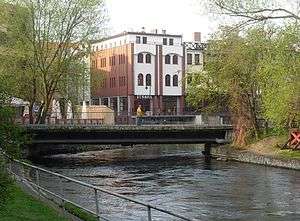
Przyrzecze Street in Bydgoszcz
| Bydgoszcz | |
|---|---|
| Polish: Ulica Przyrzecze w Bydgoszczy | |
|
View from Wyspa Młyńska | |
|
Location on a city map | |
| Former name(s) | Brahe gasse |
| Part of | Bydgoszcz |
| Owner | City of Bydgoszcz |
| Length | 160 m (520 ft) |
| Area | Old Town |
| Location | Bydgoszcz |
Przyrzecze Street is a located in the old town district of Bydgoszcz, Poland. Many of its buildings are part of Bydgoszcz local history. Due to the proximity of the river, its townhouses represent a picturesque urban complex.
Location
The street is located in the western part of Bydgoszcz old town, along Młynówka (English: Mill River), a branch of Brda river which borders Mill Island on its western, southern and eastern sides. The short street (160m long) runs roughly on a north-south axis, from Farna Street to Długa street. The street connects with Mill Island via the Mill Bridge (Polish: Most Młyński), which has been standing on this spot since 1791, but has been re-built many times.
History
Period prior to Poland partitions (1795)
Przyrzecze Street was laid out in the middle of the 14th century, during the formation of Bydgoszcz Old Town. It ran on the western outskirts of the city of Bydgoszcz, on the border of the Młynówka branch.[1].
At that time, the street was connected in the north to Grodzka Street and to the Młyńska Bridge (at the very spot of today's foot bridge leading to Opera Nova). At the end of the 18th century, with the extension of the cemetery around the Cathedral, Przyrzecze street northern tip ended to Farna Street, as it is nowadays.

During an archaeological rescue survey carried out in the area, fragments of a wooden structure were unveiled. Presumably, it was a wood-covered street, running along the banks of the Młynówka river, including[2]:
- Relics of the pavement discovered at a depth of 1.6 metres (5.2 ft) to 1.7 metres (5.6 ft) below today's surface;
- Remnants of a wooden water pipe pointing towards the river;
- Below the wooden layer, ceramics from the end of the 14th century.
Prussian period
On the first detailed plan of Bromberg, realized in 1774 by Prussian geometer Greth, most of the buildings on Przyrzecze street are located on the southern part, near Długa street. In the northern part, houses were only present in the eastern frontage, as backsides of tenements located on parallel Jezuicka Street. Like today, the northern area of Przyrzecze street gently slided down to the river, offering a public access to water collection.[3]
On a plan of the city from 1876, the development of the street is similar as today, with townhouses on the easten side, and industrial buildings on the west side. Indeed, the city expanded during the second half of the 19th century along the Brda river and many industrial plants such as tanneries, breweries and distilleries began to emerge here. Frontages with odd numbers were the back of houses on Jezuicka street and even numbers were borne by building courtyards giving onto Młynówka river, as one can still observe today along the water side (Venice of Bydgoszcz).[3]
Interwar Period and German occupation
The street, by its seclusion and its design became a refuge for Bydgoszcz outcasts, even during German occupation of the city. Hence, the renaming of the alley between 1939 and 1945, as Flunderweg (from the muddy flounder fish).[3]
Postwar period
After the second World War, real estate, nationalized, fell into ruin. In the 1970s, Przyrzecze street was considered as one of the ugliest in the city, primarily because it did not give onto the Brda river. In 1974, a city authorities decided to reconstruct this area, as part of the overall plan to "renovate Old Town old buildings". Works started first with Jezuicka and Przyrzecze streets and the first modernized buildings were completed by 1980.[4]
In 1990, several houses on the Młynówka river have been demolished, such as Przyrzecze 5 and a wattle and daub water mill that stood near the bridge leading to Mill Island. Between 2000 and 2010, four houses were built on their plots, as a continuation of the Venice of Bydgoszcz water front.
At the beginning of the 21st century, tenement houses on the eastern frontage have been refurbished, with City Hall offices and other institutions moving in.[5] In 2010, Przyrzecze street was included in the Revitalization Plan of Bydgoszcz.[6].

Naming
Through history, the street bore the following names:[7]
- From 16th century to first half of the 18th century, Platea aquatica (Latin, Water street);
- 1750-1840, Wasser Gasse (German, Water street);
- 1840-1920, Brahegasse (German, Brahe Alley, Brahe was the Prussian name of Brda river);
- 1920-1939, Ulica Przyrzecze;
- 1939-1945, Flunderweg;
- Since 1945, Ulica Przyrzecze.
Current street name refers to the proximity with the Młynówka river. In Polish, Przyrzecze means By the river (przy-rzeka).
Main places and buildings
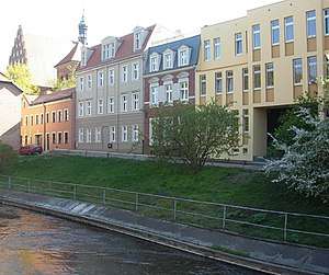
Przyrzecze Street, adjacent to the Młyńska river and Mill Island, is part of the eastern side of of the Venice of Bydgoszcz. Some tenement houses dates back to the 18th century and have been remodeled, others have been erected during the renovation of the area in the 1990s.
Tenements at N°2 & 4
Eclecticism, Neoclassical architecture
The plot on N°2, then Brahegasse 9, was purchased by a tan leather, Michał Zamoiski; his son, Frederick continued to run the workshop[3]. In 1846, Ludwig Casimir Buchholz, a master tanner from Koronowo bought the tannery. To keep the pace with his successful business, Buchhloz extended the activity to current Garbary Street 2, along the main branch of Brda river. The house at Przyrzecze 2 was then rented: first tenant was a shoemaker and his workshop. The Buchholz family owned both properties till 1922.[3]
The plot at N°4 has first been a storage area (German: speicher) when constructed[9]. In the 1890s, the area was referenced as a garden, or as non built, even in the 1930s[10]
Today, the ensemble houses the District Prosecutor's Office of Bydgoszcz-North (Polish: Prokuratura Rejonowa Bydgoszcz-Północ). The architectural complex comprises:
- a neoclassical building at N°2 (pink facade), topped by stuccoed frieze;
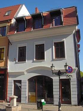
- an eclectic house at N°4 (yellow facade), with the wooden main door, featuring a transom light with stained glass motifs. Its roof displays two nice eye dormers;
- a modern edifice (green elevation), added later to N°4.
 Facades on Młynówka river
 Facades from the street
 Frieze on top of N°2
 N°4 from the street
 Main door of N°2/4
Tenement at N°5 now gone
19th century[8]
The property at N°5, then Brahegasse 12, was associated with house at Neue Pfarstraße 12, today's Jezuicka Street 4, as an outbuilding. Buildings were razed in 1990.
Tenement at N°6 now gone
1834-1855[11]
Property at N°6 was once a garden falling to the river, attached to a tenement at Jezuicka Street 4. In 1839, the owner, Frederick Wilhelm Kutzer, a tanner, sold the garden to Wilhelm Ferdinand Miller, a merchant who built a house here. His son transformed the house to a steam bath on stilts over the river, similar to the one he had already at N.8.[3] In 1870, this property was purchased by Paulina Ventzki. Following landlords were investors: rentier Maaß[12], cooperative owner August Albrecht[13] and merchant Franciszek Buczkowski[14], who had a cheese dairy shop at the Old Market. The edifice was rebuilt in the 1930s[4].
The tenement was a real icone of the Venice of Bydgoszcz, till its demolition in 1990[11]. Building side on the river displayed two-storey, with characteristic galleries running all along the facade: as such the house was known as"The Gallery (Polish: Galeriowiec). The edifice comprised also an attic and two side wings. Today the plot is empty, with a lawn overlooking the river.
 N6 facade on the river, ca 1968
Tenement at N°7
Throughout the Polish partition period (1795-1920), owners were the Wołowski family. Together with Brahegasse 11 (today's Jezuicka 8), it formed one architectural ensemble[3]. The house has been rebuilt in the 1990s, and integrated to tenements 9 to 13 to fit, among others, the city Department of Civil Affairs (Polish: Wydział Spraw Obywatelskich - WSO) and a post office.
 Current view of the renovated frontage (N°7 to 13)
 Facade at N7
Tenement at N°8 now gone
1890s[8]
In the late 18th century, on the plot was built a small tenement and a granary[3]. Both edifices changed owners regularly: the place was used as a storage and workshop area (vinegar factory, leather shop in the 1860s). In 1869, landlord's son (Miller the young) expanded the building to house bath cabins over the river, supported by wooden stilts. The interior was divided into several separate cabins that could be lowered down to the water by a system of chains. The great success of this business allowed Miller to open a similar bath house at today's N°6 a few years later[3].
Like tenement at N°6, Miller's bath house was a long-lasting iconic emblem of Bydgoszcz Venice. The edifice was demolished in 1990. [4].
 1944 postcard with both gone houses, 6 (left) and 8 (right)
Tenements at N°10, 12 & 14 now gone
1890s[8]
Before 1795, Tomasz Ossowski, owned a brewery on this area, stretching over Brahegasse 2, 3 and 4[3]. The Ossowski was a very wealthy and influencial Polish family from Bydgoszcz:
- Family also owned tenemtn (now gone) at N°21, 23 and 26;
- before Tomasz, Sebastian Ossowski founded in 1637 the St. Sebastian chapel in St. Martin and St. Nicholas Cathedral;
- Sebastian's granddaughter, Katarzyna, was the wife of Bydgoszcz mayor, Wojciech Łochowski (The Young).
Tomasz's heir, Regina, sold the 3 houses at 10, 12 and 14 to Prussian citizens : Andrzej Roch and Henry Brinkmann. After a series of owners, a restaurateur, Carl Wagner, bought the ensemble in the second half of the 19th century. The second husband of his widow, Bartłomiej Czerwiński[3], opened there another restaurant[9], which has been in business till the end of the second World War. The establishment was very popular in Bydgoszcz.
Building ensemble has been dismantled in the second half of the 20th century, during a re-construction of the Mill Bridge; today, the place is not built and offers a clear area during summer times for food vendors and nearby bar terraces. Poet Wojciech Banach (born 1953 in Bydgoszcz) has been living in one of these houses in his youth[15].
Tenement at 13
The house has been rebuilt in 2006, and integrated to tenements 7 to 11 to fit, among others, the city Department of Civil Affairs (Polish: Wydział Spraw Obywatelskich - WSO) and a post office.
 Facade at N9
 Facade of the post office at N11/13
Tenement at N°15
1990s-2000s
First buildings, referenced at N°21 and 23 (then Brahegasse 21 & 22), were propriety of Ossowski family, till 1835.[3] The ensemble has been razed at the end of the 20th century, a large habitation house complex stands now on this spot.
 View from Mill Island
House at Długa street 11, corner with Przyrzecze Street
19th century[16]
The house was inhabited during almost a century by the Lebenheim family (Amalie, Jacob, Wilhem) who worked in the leather business,[16][17] when the address was "Friedrich Straße 43". This tenement ends the southern branch of Przyrzecze Street.
 View from Długa street
See also
| Wikimedia Commons has media related to Przyrzecze Street in Bydgoszcz. |
- Bydgoszcz
- Farna Street in Bydgoszcz
- Jezuicka Street in Bydgoszcz
- Mill Island in Bydgoszcz
- Długa street in Bydgoszcz
References
- ↑ Licznerski, Alfons (1974). O dawnych wodnych młynach bydgoskich. Kalendarz Bydgoski. Bydgoszcz: Towarzystwo Miłośników Miasta Bydgoszczy. p. 54.
- ↑ Dygaszewicz, Elżbieta (1996). Bydgoszcz przedlokacyjna i lokacyjna w świetle nadzorów i archeologicznych badań ratowniczych. [w.] Materiały do Dziejów Kultury i Sztuki Bydgoszczy i Regionu. zeszyt 1. Bydgoszcz: Dokumentacji i Popularyzacji Zabytków Wojewódzkiego Ośrodka Kultury w Bydgoszczy.
- 1 2 3 4 5 6 7 8 9 10 11 12 Gordon, Wincenty (1970). Bydgoskie Stare Miasto. Ulica Przyrzecze. Kalendarz Bydgoski. Bydgoszcz: Towarzystwo Miłośników Miasta Bydgoszczy. p. 67.
- 1 2 3 Wiśniewski, Józef (1974–1975). Problemy kształtowania się rewaloryzacji zespołu staromiejskiego w Bydgoszczy. Kronika Bydgoska VI. Bydgoszcz: Towarzystwo Miłosnikow Miasta Bydgoszczy - Bydgoskie Towarzystwo Naukowe. p. 40.
- ↑ Michał, Sitarek (6 April 2006). "Dowody w nowej szacie". expressbydgoski.pl. Express Bydgoski. Retrieved 30 July 2017.
- ↑ bog (16 April 2010). "Stary Rynek. Stare znaki na nowych ulicach". Gazeta Pomorska. Gazeta Pomorska. Retrieved 30 July 2017.
- ↑ Czachorowski, Antoni (1997). Atlas historyczny miast polskich. Tom II Kujawy. Zeszyt I Bydgoszcz. Toruń: Uniwersytet Mikołaja Kopernika.
- 1 2 3 4 5 Bruski, Rafał (7 August 2015). Zarządzenie Nr 439/2015 Preyidenta Miasta Bydgoszczy -location=Bydgoszcz. Miasta Bydgoszczy. p. 64.
- 1 2 Wohnungs-Anzeiger nebst Adress-und Geschäfts-Handbuch für Bromberg und Umgebung: auf das Jahr 1872. Bromberg: Mittler. 1872. pp. VIII.
- ↑ Weber, Władysław (1933). Książka Adresowa Miasta Bydgoszczy. Bydgoszcz: Władysław Weber. p. 158.
- 1 2 maw (30 June 2005). "Galeriowiec w Wenecji". pomorska.pl. Gazeta Pomorska. Retrieved 2 August 2017.
- ↑ Wohnungs-Anzeiger nebst Adress-und Geschäfts-Handbuch für Bromberg und Umgebung: auf das Jahr 1885. Bromberg: Mittler. 1885. pp. VI.
- ↑ Wohnungs-Anzeiger nebst Adress-und Geschäfts-Handbuch für Bromberg und Umgebung: auf das Jahr 1890. Bromberg: Dittmann. 1890. p. 15.
- ↑ Wohnungs-Anzeiger nebst Adress-und Geschäfts-Handbuch für Bromberg und Umgebung: auf das Jahr 1895. Bromberg: Dittmann. 1895. p. 15.
- ↑ bog (16 April 2010). "Stary Rynek. Stare znaki na nowych ulicach". Gazeta Pomorska. Gazeta Pomorska. Retrieved 30 July 2017.
- 1 2 Allgemeiner Wohnungs-Anzeiger fur Bromberg 1855. Bromberg: Aronsohn. 1855. p. 54.
- ↑ "Straßen". Adressbuch nebst allgemeinem Geschäfts-Anzeiger von Bromberg mit Vorvorten. Bromberg: Dittmann. 1917. p. 115.
Bibliography
- (in Polish) Derenda, Jerzy (2006). Piękna stara Bydgoszcz. Tom I z serii: Bydgoszcz miasto na Kujawach. Bydgoszcz: Towarzystwo Miłośników Miasta Bydgoszczy. ISBN 9788391617809.
- (in Polish) Gordon, Wincenty (1970). Bydgoskie Stare Miasto. Ulica Przyrzecze. Kalendarz Bydgoski. Bydgoszcz: Towarzystwo Miłośników Miasta Bydgoszczy. p. 67.
- (in Polish) Umiński, Janusz (1996). Bydgoszcz i okolice: Przewodnik. Bydgoszcz: Regionalny Oddział PTTK „Szlak Brdy”. ISBN 9788321725239.
Coordinates: 53°07′19″N 17°59′53″E / 53.12194°N 17.99806°E

