Future Interstate Highways
| Dwight D. Eisenhower National System of Interstate and Defense Highways | |
|---|---|
|
Shields for future Interstates | |
|
Interstate Highways proposed | |
| System information | |
| Formed: | June 29, 1956[1] |
| Highway names | |
| Interstates: | Interstate X (I-X) |
| System links | |
.svg.png)
.svg.png)
Future Interstate Highways include various proposals to establish new mainline (one- and two-digit) Interstate Highways in the United States. This does not include the numerous auxiliary Interstate Highways that are in various stages of planning and construction. Planned expansion of existing mainline interstates are also not included here.
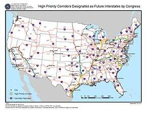
Congressionally designated future Interstates
Several Congressional High Priority Corridors have been designated as future parts of the Interstate System by the Intermodal Surface Transportation Efficiency Act and amendments. By law, they will become interstates when built to Interstate standards and connected to other interstates.[2][3]
Interstate 3
| |
|---|---|
| Location: | Savannah, GA to Knoxville, TN |
Interstate 3 is the proposed designation of an Interstate Highway Corridor under development in the southeastern U.S. It is planned to run from Savannah, Georgia, to Knoxville, Tennessee. Its number does not follow standard numbering conventions; under established numbering conventions I-3 would normally run west of I-5 along the Pacific Coast. The unnumbered Interstate was established by the Safe, Accountable, Flexible, Efficient Transportation Equity Act: A Legacy for Users (SAFETEA-LU) legislation that also provided for Interstate 14. The "Interstate 3" designation has not been officially accepted by AASHTO or the FHWA, but is being used by the Georgia Department of Transportation and others to identify the highway. The number comes from the 3rd Infantry Division which is based in Georgia. Portions of the planned route, including the Savannah River Parkway, are already built to Interstate standards; the exact route has not been finalized, especially across the Appalachian Mountains north of Augusta, Georgia.
Interstate 7 or 9
| Interstate 7 or 9 | |
|---|---|
| Location: | Wheeler Ridge, CA – Stockton, CA |
Interstate 7 or Interstate 9 has been proposed by Caltrans for State Route 99 in central California. It would go from the split with I-5 at Wheeler Ridge (Wheeler Ridge Interchange) north through Fresno to Stockton, where the proposed route turns west via the State Route 4 freeway to a terminus at I-5 in the central part of that city. An alternate proposed terminus is located at the I-5/US 50/Capital City Freeway junction in Sacramento, where the future Interstate, after continuing north from Stockton along Route 99, can turn west along the Capital City Freeway, already an Interstate route (unsigned I-305), to connect with I-5, which extends north toward the city of Redding. This also serves as a connector to the existing northern portion of Highway 99. The future Interstate's prospects for development to appropriate standards are tied to the Caltrans "Route 99 Corridor Enhancement Master Plan", which outlines improvements to that route, including capacity and physical improvements; this document posits that when and if Interstate status is conferred, the route will be designated I-7 or I-9.[4]
In August 2005, with the passage of that year's SAFETEA-LU federal transportation legislation, SR 99 from Wheeler Ridge to Stockton and beyond to Sacramento was designated as High Priority Corridor 54, the California Farm-to-Market Corridor; this legislation also designated that corridor as a future segment of the Interstate System.[5]
Interstate 11
| |
|---|---|
| Location: | Tucson, AZ, to Las Vegas, NV, or Reno, NV |
Interstate 11 is the congressionally designated route number for an Interstate connecting Phoenix, Arizona, to Las Vegas or Reno, Nevada. The concept of an Interstate connecting Phoenix and Las Vegas was first explored in the contractor-trade publication Roads and Bridges in June 1997; the article outlining the I-11 route and rationale was titled "Interstate 2000: Improvement for the Next Millennium", written by Wendell Cox and Jean Love. Their rationale was that the Phoenix and Las Vegas metro areas were two of the largest (and, circa 1997, growing) urban regions in adjacent states not featuring direct Interstate connection. The corridor would be approximately 285 miles (459 km) in length and would most likely subsume the existing I-515 freeway facility in the Las Vegas area.[6] Plans to connect I-11 to the existing Interstate network in the Phoenix region have yet to be determined. The proposed routing for I-11 is part of the CANAMEX high-priority corridor.[7] The projects contained within this portion of the overall Canamex corridor include the recently completed Hoover Dam Bypass project.[8][9][10][11] The Fixing America's Surface Transportation Act (FAST Act), signed by President Obama on December 14, 2015,[12] officially designated the Intermountain West Corridor, generally along US 95 from Las Vegas to Interstate 80, as a future Interstate highway, designating it as I-11. At the same time, it extended the southern terminus of the corridor from Phoenix through Tucson to Nogales generally via the I-10 and I-19 corridors.[13]
Interstate 42
| |
|---|---|
| Location: | Garner, NC – Morehead City, NC |
| Length: | 142 mi (229 km) |
The FAST Act added the US 70 corridor between Garner and Morehead City, North Carolina, to the Interstate system by defining it as, first, High Priority Corridor #82, and subsequently designating it as a future Interstate.[12] The Regional Transportation Alliance expected this corridor to be called I-46 or another suitable designation.[14] At a meeting in La Grange, North Carolina, on March 17, 2016, the Super 70 Corridor Commission recommended that the designation of Interstate 50 be sought for the US 70 Interstate corridor. The rationale for the I-50 numerical selection was cited as a number not in conflict with either an existing Interstate designation or currently applied to a U.S. Highway within North Carolina.[15] This recommendation was forwarded to NCDOT for submission to AASHTO.
For the AASHTO Special Committee on U.S. Route Numbering meeting in May 2016, NCDOT proposed I-36 for this route.[16] However, AASHTO instead designated the route as Interstate 42.[17][18]
Interstate 87
| |
|---|---|
| Location: | Raleigh, NC – Norfolk, VA |
| Length: | 192 mi (309 km) |
The North Carolina Department of Transportation (NCDOT) proposed the Interstate 44 designation for the Raleigh–Norfolk High Priority Corridor consisting of portions of the present I-495 and U.S. Highway 64 in North Carolina and US 17 in North Carolina and Virginia. The route would connect two of the largest US metro areas lacking an Interstate connection: the Research Triangle area around Raleigh, North Carolina, with the Hampton Roads metro area centered on Norfolk, Virginia. In November 2012, NCDOT requested the addition of the corridor to the Interstate Highway System through administrative options with the Federal Highway Administration as I-44.[19] Congressman G. K. Butterfield introduced legislation in June 2014 to add the corridor to the Interstate Highway System through Congressional authority.[20] An NCDOT policy paper said they were "seeking language in the reauthorization of surface transportation programs legislation to enhance the description of the Raleigh–Norfolk Corridor to include the route via Rocky Mount–Elizabeth City for clarity, and to designate the entire route from Raleigh to Norfolk as a future part of the Interstate system as I-44 or I-50."[21][22] This corridor was officially designated as a future Interstate with the passing of the FAST Act.[12]
Had the I-44 designation been approved, it would have been discontinuous with the current I-44, which runs between Wichita Falls, Texas, and St. Louis, Missouri. However, subsequent review of available and preferred route numbers produced two other candidates: I-56 if an east–west designation was chosen, or I-89 if a north–south designation was chosen. I-56 is not in use, while I-89 exists in Vermont and New Hampshire but is far north of this corridor.[23] For the upcoming AASHTO Special Committee on U.S. Route Numbering, NCDOT proposed I-89 for this route.[24] On May 25, 2016, AASHTO instead approved I-87 as the number for the highway,[17][18] which would be non-contiguous with the route with the same number in New York State.
Other proposals
Interstate 67
| |
|---|---|
| Location: | Indianapolis, IN – Grand Rapids, MI; South Bend, IN –Kalamazoo, MI; Bowling Green, KY; Owensboro, KY –Crane, IN |
Interstate 67 is a proposed number for at least three highways.
Indiana has proposed using the I-67 designation for the freeway upgrade of US 31 currently under construction between Indianapolis and South Bend, and possibly continuing northward via the US 31 freeway to Benton Harbor, Michigan, and going northward from there along existing I-196. The Indiana Senate unanimously passed a resolution calling for federal funding for this proposal and the I-67 designation in 2003.[25] Meanwhile, Indiana is expediting the upgrade of US-31 between Indianapolis and South Bend using funds received through the 2006 Major Moves deal. Such a proposal would put I-67 in the proper place in the grid (it is the only number available for that route). I-67 was originally the designation given to a never-built highway connecting Kalamazoo, Michigan, to the east side of Elkhart, Indiana, as part of the original Interstate numbering plan in 1957.[26] A planning map shows a freeway along this routing intersecting the Indiana Toll Road just west of the State Road 19 interchange.[27] The Michigan State Highway Department officially requested switching the I-67 designation to a route from Benton Harbor to Grand Rapids in 1958, and in the process proposed the current I-69.[28] The I-67 designation was denied by AASHO which then assigned I-196 to the Benton Harbor to Grand Rapids route, west of the I-96 junction near Grand Rapids.[29]
A third, much shorter, proposal in 2011 by the I-67 Development Corporation from the Owensboro, Kentucky, area involves continuing the proposed I-67 in Indiana along a route parallel to US 231 from Crane, Indiana, to Bowling Green, Kentucky. Much of the proposed route already exists and is close to Interstate grade. Only the northern third from Dale, Indiana, to Crane remains unfinished. It would use the Natcher Bridge to cross the Ohio River, Kentucky's Interstate-grade Natcher Parkway and Indiana's Lincoln Parkway, an expressway facility that would need to be fully upgraded to Interstate standards. It would go around the cities of Jasper and Huntingburg in Indiana as well as Owensboro, Hartford, and Morgantown, Kentucky, and end at Bowling Green. It could also be linked to the first proposal by overlapping I-67 with the currently under construction I-69 from Indianapolis to Crane.[30]
Interstate 92
| |
|---|---|
| Location: |
Albany, NY – Portsmouth, NH or Glens Falls, NY – Calais, ME |
As originally proposed by the Michigan State Highway Department in 1957, I-94 from Benton Harbor to Detroit would have been numbered Interstate 92. Since then, I-92 has been a proposed number for at least two highways.
Low population and natural barriers like the White Mountains have impeded economic development in northern New England. In the early 1970s, Maine, New Hampshire, Vermont, and New York proposed two new Interstate Highway corridors:
- From Albany, New York, to Portsmouth, New Hampshire, incorporating the current route whose easternmost segment is New Hampshire Route 101.
- From Glens Falls, New York, to Calais, Maine (designated as I-92), tracing U.S. Route 4 eastward through Vermont and New Hampshire.
The Federal Highway Administration ultimately did not approve these plans.
Northern New England is served by three north–south freeways radiating from Boston, and by Interstate 91, which follows the Connecticut River. However, the northernmost complete east–west freeway in the region, Interstate 90 in Massachusetts, does not enter northern New England. East–west travel through northern New England is facilitated by three freeway segments:
- Interstate 89 between Montpelier, Vermont, and Burlington.
- US 4 west of Rutland, Vermont.
- New Hampshire Route 101 from Manchester, New Hampshire eastward to the ocean.
Maine Senator Olympia Snowe said in 2004 that the region is disadvantaged by the fact that it was the only region in the US for which a federal High Priority Corridor was not designated in the 1991 Intermodal Surface Transportation Efficiency Act.[31] In 2012, the east–west highway was again proposed, this time as a privately financed toll road.[32]
Current backers of the highway propose an east–west axis through northern and central Maine. One portion of the new highway would run from Interstate 395 in Brewer, Maine, to the Canadian border near Calais, with a direct link to New Brunswick Route 1, a major transportation corridor serving the Maritimes. A second would travel northwest from Interstate 95 near Waterville, Maine, to the Canadian border at Coburn Gore, with a connection to a proposed extension of Quebec Autoroute 10 toward Montreal. A third would travel due west from I-95 near Waterville, following the U.S. Route 2 corridor through Maine, New Hampshire, Vermont, and northern New York.
Interstate 98
| |
|---|---|
| Location: | Watertown, NY–Swanton, VT |
As originally proposed by the Michigan State Highway Department in 1958, I-696 would have been numbered Interstate 98.[28] Since then, another highway in Upstate New York and Vermont has been linked to the number. Plans for the Rooftop Highway, a proposed limited-access highway that would extend for 175 miles (282 km) from Watertown, New York, to Swanton, Vermont, first surfaced in the 1950s. If built, the highway would likely follow the US 11 corridor across the northern part of New York's North Country, connecting I-81 to I-89. The project is expected to create more than 27,000 jobs throughout the North Country and is expected to take as many as 15 years to complete.
A study called the North Country Transportation Study Action Plan and Final Technical Report suggests that the road would likely be built to Interstate Highway standards in order to improve constrained transit systems due to a lack of infrastructure throughout the area. Backers of the project have called for the highway to be designated as I-98;[33] however, this designation has not been recognized by any government agencies, such as NYSDOT or the AASHTO. The number does fit into AASHTO's numbering system, though, as the highest even numbers are designated for highways running along the Canadian border, such as the proposed highway.
The Northern Corridor Transportation Group (NCTG) was formed in December 2008 as a means of refocusing the fifty-year discussion on the project. Since that time, more than 100 municipal and civic resolutions from the five northern counties of New York have been passed in support of the construction of the project. On July 16, 2009, the NCTG submitted a request to U.S. Senator Kirsten Gillibrand to direct $800 million toward the project as part of the reauthorization of a federal highway transportation bill. In a historic move, the six northern legislators representing the North Country in the New York State Legislature (Senators Aubertine, Griffo and Little and Assembly Members Scozzafava, Russell and Duprey) signed an official letter of request to the same end.
See also
References
- ↑ Weingroff, Richard F. (Summer 1996). "Federal-Aid Highway Act of 1956, Creating the Interstate System". Public Roads. Washington, DC: Federal Highway Administration. 60 (1). Retrieved March 16, 2012.
- ↑ United States Congress. "National Highway System Designation Act of 1995". Library of Congress.
- ↑ Staff (May 2, 2006). "Future Interstates on the National Highway System Designated by Section 1105 of ISTEA as amended". Federal Highway Administration. Archived from the original on September 26, 2006.
- ↑ "Chapter 3" (PDF). Caltrans Route 99 Enhancement Plan (PDF). California Department of Transportation.
Interstate designation, under the current proposal, would apply to the 260-mile (420 km) segment between the junction of State Route 99 with I-5 south of Bakersfield to I-5 in Stockton using State Route 4 as the connector to I-5. Since there is an I-99 route currently in existence in Pennsylvania, it is anticipated that should designation be granted, the Route 99 designation would become either I-7 or I-9 to satisfy Interstate numbering convention.
- ↑ United States Congress. "Safe, Accountable, Flexible, Efficient Transportation Equity Act: A Legacy for Users". Library of Congress.
- ↑ Cox, Wendell & Love, Jean (June 1997). "Interstate 2000: Improvement for the Next Millenium". Roads & Bridges. Retrieved December 1, 2013.
- ↑ "Proposed Hassayampa Freeway map" (Map). Las Vegas Sun.
- ↑ "Hoover Dam Bypass". Central Federal Lands Highway Division and HDR Engineering.
- ↑ "US 93 corridor in Arizona". Arizona Department of Transportation. Retrieved June 2, 2013.
- ↑ "Quick Status Update and Upcoming Activities: July–August 2009" (PDF) (Press release). Hoover Dam Bypass Project.
- ↑ Norman, Jean Reid (August 12, 2009). "Boulder City Council endorses Vegas-to-Phoenix interstate". Las Vegas Sun.
- 1 2 3 https://www.congress.gov/114/bills/hr22/BILLS-114hr22enr.pdf#page=111
- ↑ Arizona Department of Transportation Media Relations (December 4, 2015). "Interstate 11 Receives Designation in Federal Transportation Funding Bill" (Press release). Arizona Department of Transportation. Retrieved December 7, 2015.
- ↑ "A victory ten years in the making". RTA.
- ↑ Wilson, Marcia R. (March 17, 2016). "Minutes and Summary" (PDF). La Grange, NC: Highway 70 Corridor Commission of North Carolina. Retrieved April 7, 2016.
- ↑ "AASHTO Electronic Balloting System, View Ballot, Agenda and List of Applications, SM-2016" (PDF). AASHTO. Retrieved May 5, 2016.
- 1 2 Vitale, Marty (May 24, 2016). "Special Committee on U.S. Route Numbering" (PDF) (Report). Des Moines, IA: American Association of State Highway and Transportation Officials. Retrieved May 26, 2016.
- 1 2 Siceloff, Bruce (May 25, 2016). "Future interstate highway names approved". News & Observer. Retrieved May 25, 2016.
- ↑ Gibson, Terry R. (November 27, 2012). "Designation of I-44" (PDF) (Letter). Letter to John F. Sullivan III. Raleigh, NC: North Carolina Department of Transportation. Retrieved May 15, 2014.
- ↑ Tata, Anthony J. (June 11, 2014). "Route to Opportunity and Development Act (ROAD Act)" (PDF) (Letter). Letter to G.K. Butterfield. North Carolina Department of Transportation. Archived from the original (PDF) on May 23, 2015. Retrieved September 4, 2014.
- ↑ "Future Interstate Designation: Raleigh, NC to Norfolk, VA" (PDF). North Carolina Department of Transportation. June 11, 2014. Archived from the original (PDF) on May 23, 2015. Retrieved September 4, 2014 – via Regional Transportation Alliance.
- ↑ "Interstate 495 to Rocky Mount—Future I-44 to Hampton Roads". Raleigh, NC: Regional Transportation Alliance. December 14, 2013. Retrieved February 16, 2014.
- ↑ "Raleigh-Norfolk: I-495, I-44, I-50, I-89, I-56 ... ?". Raleigh, NC: Regional Transportation Alliance. December 31, 2015. Retrieved February 1, 2016.
- ↑ "AASHTO Electronic Balloting System - View Ballot - Agenda and List of Applications SM-2016" (PDF). AASHTO. Retrieved May 5, 2016.
- ↑ "Zakas' Resolution Passes Senate Unanimously; Bill supports efforts of Indiana Congressional Delegation to seek federal funding for US 31 freeway project" (Press release). State of Indiana Senate District 11. Archived from the original on March 11, 2007. Retrieved July 6, 2009.
- ↑ Public Roads Administration (August 14, 1957). Official Route Numbering for the National System of Interstate and Defense Highways (Map). American Association of State Highway Officials – via Wikimedia Commons.
- ↑ "FAI9 1957". Indiana Interstates: 1957 Interstate Highway System. Archived from the original on June 23, 2002. Retrieved May 7, 2008.
- 1 2 Staff (April 25, 1958). Recommended Interstate Route Numbering for Michigan (Report). Michigan State Highway Department. Archived from the original on August 5, 2004. Retrieved September 4, 2010.
- ↑ "Would Shift Route Number: Mackie Seeks Int. 96 Designation for Grand Rapids–Muskegon Stretch". The Grand Rapids Press. May 1, 1963. p. 31. OCLC 9975013.
- ↑ GO-EDC (January 13, 2012). "Facts about Interstate 67 as Owensboro's interstate". Owensboro Economic Development Blog. Greater Owensboro Economic Development Corporation. Retrieved October 10, 2012.
- ↑ Senator Olympia Snowe (June 25, 2004). "East–West Highway Will Connect Mainers to All Points In-Between and Beyond". Weekly Senate Update. Archived from the original on July 1, 2011.
- ↑ "Transportation Committee passes bill for east-west highway study". Bangor Daily News. Retrieved February 18, 2012.
- ↑ "It's now I-98, not Rooftop Highway". Adirondack Daily Enterprise. Saranac Lake, NY. August 1, 2009. Retrieved February 2, 2011.
External links
| Signed | |
|---|---|
| Unsigned | |
| Lists | |
| Other | |
Major Interstates highlighted | |