Potsdam-Mittelmark
| Potsdam-Mittelmark | |
|---|---|
| District | |
 | |
| Country |
|
| State | Brandenburg |
| Capital | Belzig |
| Area | |
| • Total | 2,575.4 km2 (994.4 sq mi) |
| Population (31 December 2015)[1] | |
| • Total | 210,910 |
| • Density | 82/km2 (210/sq mi) |
| Time zone | CET (UTC+1) |
| • Summer (DST) | CEST (UTC+2) |
| Vehicle registration | PM |
| Website | potsdam-mittelmark.de |
Potsdam-Mittelmark is a Kreis (district) in the western part of Brandenburg, Germany. Its neighbouring administrative units are (clockwise from the north) the district of Havelland, the free cities of Brandenburg and Potsdam, the state of Berlin, the district of Teltow-Fläming, and the districts of Wittenberg, Anhalt-Bitterfeld and Jerichower Land in Saxony-Anhalt.
Geography
The district includes the southern banks of the Havel river and the northern parts of the Fläming (a wooded hill chain). There are three nature parks in the district: High Fläming Nature Park, Nuthe-Nieplitz Nature Park and Westhavelland Nature Park.
History
The district was created in 1993 by merging the previous districts of Belzig, Brandenburg-Land and Potsdam-Land.
Demography
 Development of Population since 1875 within the Current Boundaries (Blue Line: Population; Dotted Line: Comparison to Population Development of Brandenburg state; Grey Background: Time of Nazi rule; Red Background: Time of Communist rule)
 Recent Population Development (Blue Line) and Forecasts
|
|
|
|
Coat of arms
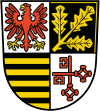 |
The coat of arms is divided into four fields. The left top one shows a red eagle as the symbol of Brandenburg. The three oak-leaves in the top right both symbolize the prevalent oak forests, but also the three previous districts which were merged to form the current one. In the bottom right are two bishopric keys, which stand for the diocese of Brandenburg. The black-and-golden bars in the bottom left are the symbol of Saxony, and symbolize that the area around Belzig, Brück, Wiesenburg and Niemegk belonged to Saxony until 1815. |
Towns and municipalities

| Amt-free towns | Ämter | |
|---|---|---|
|
|
1. Beetzsee 2. Brück 3. Niemegk |
4. Wusterwitz 5. Ziesar |
| 1seat of the Amt; 2town | ||
References
- ↑ "Bevölkerung im Land Brandenburg nach amtsfreien Gemeinden, Ämtern und Gemeinden 31. Dezember 2015 (Fortgeschriebene amtliche Einwohnerzahlen auf Grundlage des Zensus 2011)". Amt für Statistik Berlin-Brandenburg (in German). 2016.
- ↑ Detailed data sources are to be found in the Wikimedia Commons.Population Projection Brandenburg at Wikimedia Commons
External links
![]() Media related to Potsdam-Mittelmark at Wikimedia Commons
Media related to Potsdam-Mittelmark at Wikimedia Commons
- Official website (in German)
| Urban districts | |
|---|---|
| Rural districts | |
Coordinates: 52°12′N 12°45′E / 52.200°N 12.750°E