Porto Grande Bay
| Porto Grande Bay | |
|---|---|
|
Porto Grande | |
| Location | Northwest of São Vicente, Cape Verde |
| Coordinates | 16°53′N 25°01′W / 16.89°N 25.01°W |
| Max. length | 6 km (3.7 mi) |
| Max. width | 5 km (3.1 mi) |
| Average depth | 15 m (49 ft) |
_p0173_CAPE_VERDES%2C_PORTO_GRANDE.jpg)
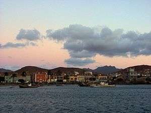
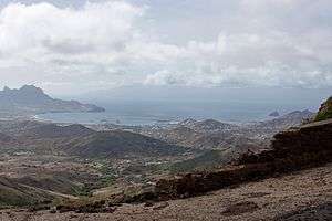
Porto Grande Bay, also as Mindelo Bay (Portuguese: Baía do Porto Grande) is a bay on the north coast of the island of São Vicente, Cape Verde. The main city of São Vicente, Mindelo, is situated at the bay. The Porto Grande Bay is a deep natural harbour, formed by an underwater volcanic crater of about 4 kilometer diameter, the area is approximately 20 km² and the depth ranges from 15 to 30 m. Along with Praia Harbor in area, it is the largest port and harbour in Cape Verde but second in activity for Porto Grande. It stretches between the headlands Ponta João Ribeiro in the northeast and Morro Branco in the west. To the northwest it opens towards the Canal de São Vicente, the channel between the islands São Vicente and Santo Antão. The small rocky island Ilhéu dos Pássaros lies north of the bay. The port's location being inside the Atlantic Ocean sits at or within the major sea-lanes linking Europe to South America, the other linking North America to southern Africa or Australia, much of its ships bypasses the archipelago today.
About the port
The port is owned and operated by ENAPOR and is co-owned by the Canarian company Armas.
It offers ferry services to the nearby island of Santo Antão with Porto Novo and serves twice a day and has a boat carrying 450 passengers and also carries auto traffic, its ferry route crosses the channel and is accessed in 50 minutes each way. It also has ferry routes to Fogo and Brava twice a week and Santiago and São Nicolau once a week. All ferry services to Sal are done via São Nicolau, to Maio via Santiago and to Boa Vista via Sal and São Nicolau.
The shipyard has been used as a naval station especially for the Capeverdean Navy (Cabnave), it is used as a repair base even for foreign naval ships. It is measured 110 x 18 meters and has 145 meters of quay. Also in that location it also has its own lighthouse used for naval and probably non-naval ships. Its focal height is 8 meters and its range is around 14-15 km (8 nmi).[1]
The bay is considered one of the seven wonders of Cape Verde,[2] on November 12, 2013, it became the fifth most beautiful bay in the world.[3]
History
During the Last Ice Age, it was once a small caldeira that was surrounded by a rim in the north and west and belonged to the larger "Northwestern Island" as the sea levels were around 150 m lower, when the sea level was about 25 m lower, the caldeira area was flooded and formed Porto Grande Bay, the northern peninsula was once hook shaped, before the sea levels reached the current level, Ilhéu dos Passos was formed after it separated from the island.
Along with the island, the bay was first explored and charted on January 22, 1462, Saint Vincent's Day. In 1624, a Dutch fleet which had 3,300 sailors, commanded by admiral Jacob Willekens passed through the bay before he conquered Bahia in Brazil. The harbour was mentioned in the 1747 French/Dutch map by Jacques Nicolas Bellin.[4]
Mindelo was founded in 1795 along with its tiny port, around the mid 19th century, a coal deposit was established to supply ships on Atlantic routes, the port was expanded by the British and also used Cape Verde as a storage depot for imported coal bound for the Americas. In 1875, Cory Brothers, a coal shipping company opened next to the bay, it increased usage. Ships were stopped in Mindelo for refueling, first 669 ships were refueled each year in 1879, later 1,927 ships stopped in Porto Grande in 1889 and was the highest ever reached. Also in 1874, telegraph cables were established in two parts, one southwest of Ilhéu dos Pássaros and the other northeast and passed halfway between Ribeira Julião Point and the islet, as telegraphs went out of use, they are now called communications line are now even used for Internet signals and connected with Pernambuco, Brazil via Madeira, West and Southern Africa and the United States in 1884 and Cameroon via Bathurst (now Banjul) in 1885. As coal were being replaced by petroleum fuel, the number of ship visits dropped, one part, the opening of the Suez Canal in Egypt, shipping activity ceased in the 1930s, ship traffic did not fully resumed until around 1950, the last ship refueled with coal was in 1952, Mindelo's and the island's economy were devastaded for decades. The port was mentioned in a map and a nautical chart from 1884 that is now at the British Museum Library. In April 1922, aviators Gago Coutinho and Sacadura Cabral boarded a hydroplane for the First aerial crossing of the South Atlantic which had Mindelo and the bay as its stop, it started from Lisbon and finished in Rio de Janeiro, Brazil. A monument today is erected on Avenida Marginal, the area where the hydroplane visited.[5] Porto Grande was a very small port and was within the city, the port expanded in 1962 and finished up to be nearly shaped like a letter F facing westward, its furthermost unnamed point also extended, it went west of Ponta João Ribeiro and the 25th meridian west. Until independence in 1975, the port was a Portuguese naval base. As the British coal industry went into decline in the 1980s, this source of income dried up, and Britain had to abandon its Cape Verdean interests — which ended up being the final strike to the highly dependent local and island economy.
Until 1962, it had passenger ferry service with the ports of Ponta do Sol and rarely Ribeira Grande in the island of Santo Antão, after Carvoeiros' port was completed, the services changed to that port in which the town became Porto Novo.
In 2006, ships that participated in a NATO operation known as Operation Jaguar landed in the bay to do their maneuvers for a few days, 7,000 troops took part.[6]

Several American ships made their recent visits in Mindelo, on April 26, 2007, the USS Mahan (DDG-72) visited the port of Mindelo, later on November 16, the USS Annapolis (SSN-760) visited and the US Coast Guard ship, the Dallas (WHEC-716) June 7, 2008.

Expansions
The port has undergone a few series of expansions. The first was in 1962, another expansion took place in 1997[7] as part of the Porto Grande Modernization Project, the port added 1,750 m of quays. The expansion has enlarged the port's area to 45,000 m² and it features a shipping station and a passenger terminal. The most recent expansion occurred in the northern part in 2014 and is currently expanding, the location of expansion is in the northeast and west of the Avenida Marginal, the northern part is slightly more distant.
Depictions

Along with Ilhéu dos Passaros, Porto Grande Bay and the Port of Mindelo (or Porto Grande) were featured on a Cape Verdean $500 escudo bill shown on the back issued between 1989 and 2000, Amílcar Cabral was shown in the front until 1992, the note was partly modified when a new government was established in 1992 and featured Baltasar Lopes da Silva on the front.
Gallery
 Porto Grande Bay with Monte Cara
References
- ↑ "Cape Verde". The Lighthouse Directory. University of North Carolina at Chapel Hill. Retrieved 28 April 2017.
- ↑ "The Seven Wonders of Cape Verde". Sapo CV (in Portuguese).
- ↑ "Porto Grande do Mindelo é a 5ª baía mais bela do mundo" [Porto Grande Near Mindelo, the 5th Most Beautiful Bay in the World]. A Semana (in Portuguese). 12 November 2013. Retrieved 16 July 2016.
- ↑ Jacques-Nicolas Bellin; Pieter de Hondt (1747). "Carte des Isles du Cap Verd = Kaart van de Eilanden van Kabo Verde" (in French).
- ↑ Pereira, Armand F. ""Summary of the First Southern Atlantic Crossing (1922) by the Portuguese Aviators Gago COUTINHO and Sacadura CABRAL on a Fairey-17 Single Engine Hydroplane"". HoneyMooney.com. Retrieved January 7, 2013.
- ↑ "Landung auf den Kapverden" [Landing in Cape Verde]. BZ Online (Berliner Zeitung) (in German). 26 June 2006.
- ↑ Africa South of the Sahara 2004. Europa & Psychology Presses. 2003. p. 190. ISBN 1857431839. (part of (Europa Regional Surveys of the World 2004 Series)
External links
| Wikimedia Commons has media related to Porto Grande Bay. |
Coordinates: 16°53′N 25°01′W / 16.89°N 25.01°W
