Pora (river)
| Pora | |
|---|---|
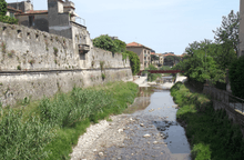
 The Pora near its mouth | |
 | |
| Country | Italy |
| Basin features | |
| Main source |
Ligurian Alps 1,000 m (3,300 ft) |
| River mouth |
Ligurian Sea in Finale Ligure (SV, Italy) 0 m (0 ft) 44°10′01.9″N 8°20′28.75″E / 44.167194°N 8.3413194°ECoordinates: 44°10′01.9″N 8°20′28.75″E / 44.167194°N 8.3413194°E |
| Basin size | 59 km2 (23 sq mi)[1] |
| Physical characteristics | |
| Length | 15 km (9.3 mi)[2] |
The Pora (or Porra[3]) is a 15-kilometre (9.3 mi) stream of Liguria (Italy).
Geography

The stream near Rialto

The Pora in Finalborgo
The river rises at around 1000 m in the Ligurian Alps, not faraway from Colle del Melogno, at the jonction between rio Rivase and Rio Peccione, in the comune of Rialto. Flowing in the Valle Pora it passes through the comune of Calice Ligure, where it receives from left the waters of torrente Carbuta. Heading south-east the Pora reaches Finlaborgo and gets its main tributary, torrente Aquila; a couple of km downstream it ends its course in the Ligurian Sea, after being crossed by the Genoa–Ventimiglia railway and the Aurelia national road.
Pora basin (59 km2) is totally included in the Province of Savona
Main tributaries

Torrente Aquila.
- Left hand:
- Torrente Carbuta (watershed 6 km2): it comes from Pian dei Corsi and enters the Pora in Calice Ligure;
- Torrente Aquila (watershed 21 km2): from Monte Alto (956 m) in heads South and crosses the comune of Orco Feglino joining the Pora in Finalborgo;
- Right hand:
- Rio Ravin: comes from the SE slopes of Bric Gettina;
- Rio Molino.
References
- ↑ (in Italian)PIANO DI BACINO STRALCIO SUL RISCHIO IDROGEOLOGICO, Provincia di Savona, on-line in pdf: (access: 2015-05-22)
- ↑ (in Italian)INTERVENTI PER LA MESSA IN SICUREZZA DEL T. PORA TRA IL PONTE DI VIA SAGITTARIO E LA FOCE, Comune di Finale Ligure, on-line in pdf: (access: 2015-05-22)
- ↑ 1:25.000 map of the Istituto Geografico Militare, on-line version:www.pcn.minambiente.it
See also
External links
![]() Media related to Pora at Wikimedia Commons
Media related to Pora at Wikimedia Commons
- (in Italian) Torrente Pora www.fipsas.it (fishing rules for the stream)
This article is issued from
Wikipedia.
The text is licensed under Creative Commons - Attribution - Sharealike.
Additional terms may apply for the media files.