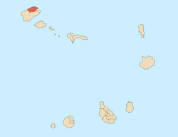
Ponta do Sol (Santo Antão promontory)
For another point in the northwest of the island of Boa Vista, see Ponta do Sol (Boa Vista)
| Ponta do Sol | |
|---|---|
 Ponta do Sol | |
| Location | Northern Santo Antão, Cape Verde |
| Coordinates | 17°12′19″N 25°05′32″W / 17.20532°N 25.09219°WCoordinates: 17°12′19″N 25°05′32″W / 17.20532°N 25.09219°W |
| Offshore water bodies | Atlantic Ocean |
| Highest point | 10 m |
Ponta do Sol is the northernmost point of both Cape Verde and the Island of Santo Antão located just only 300 meters north of the city center of Ponta do Sol. No road connects the point, but it is accessible by walking as there are no pathways. Other parts of the headland have roads as well as city streets and some pathways.
Its main etymology is not understood. One possible source of the name is that is a sunny area on the island. Another is that first inhabitants came from Ponta do Sol in the Madeira Islands of Portugal in 1584 and was one of the two island's first settlements. Another could be the geographic resemblance to Ponta do Sol on the Madeira Islands, and another could be the settlers who came to the area matched the geographic name with where the settlers who came from.
Promontory and headland
The headland is slightly more than a kilometer from south to north, and its width ranges from 300 meters in the north to 750 meters wide east to west. In that location, on a rock facing the sea, is a diver statue. On the headland is the town of Ponta do Sol, it surrounds its port, Boca de Pistoia and a slope of mountain to the south.
As the seas are rough and dangerous in the area, about 3-4 km north has a depth of 1,000 meters and forms a part of the Cape Verde Rise, about 10 km north has a depth of 2,000 meters and 15-20 km is 3,000 meters.
During the Ice Age, the point was located about 1-2 km north from its current location.
Further north of the point is the Canary Current and is near the range of its furthermost area.
A part of the headland may be artificially extended but the point in the north is natural, the northernmost part of the headland was once the island's airport named Agostinho Neto which opened in the 1960s and shut down in March 2007, the airport covered the northernmost of the headland.
Lighthouse
 Cape Verde | |
| Location |
Ponta do Sol Santo Antão Cape Verde |
|---|---|
| Coordinates | 17°12′14.9″N 25°5′22.6″W / 17.204139°N 25.089611°W |
| Year first constructed | n/a |
| Foundation | concrete base |
| Construction | metal post |
| Tower shape | cylindrical post with balcony and light atop |
| Markings / pattern | white and red horizontal bands |
| Height | 10 metres (33 ft)[1] |
| Focal height | 15 metres (49 ft)[1] |
| Light source | solar power |
| Range | 9 nautical miles (17 km; 10 mi)[1] |
| Characteristic | Fl W 4s. [1] |
| Admiralty number | D2952 |
| NGA number | 24088 |
| Cape Verde number | PT-2004[2] |
Between its former runway and the point is the lighthouse (Portuguese: Farol de Ponta do Sol).[3] It was constructed around the 20th century and was built of a concrete base and a metal post.
It has a cylindrical post with balcony and light atop, and has white and red horizontal bands, as do many lighthouses built after the 1950s through the world. As that lighthouse near Janela is no longer active, this is one of the two active on the island. The lighthouse guides ships heading to and from the island's and nearby São Vicente's port of Porto Grande, as no ships heading on the trans-Atlantic routes with South America pass within the lighthouse as the range is 17 km (9 mi) and does not reach the westernmost point in the island.
See also
- List of lighthouses in Cape Verde
- List of buildings and structures in Santo Antão, Cape Verde
- Geography of Cape Verde
References
- 1 2 3 4 List of Lights, Pub. 113: The West Coasts of Europe and Africa, the Mediterranean Sea, Black Sea and Azovskoye More (Sea of Azov) (PDF). List of Lights. United States National Geospatial-Intelligence Agency. 2015.
- ↑ "Cape Verde". The Lighthouse Directory. University of North Carolina at Chapel Hill. Retrieved 23 April 2017.
- ↑ "Lighthouses of Cape Verde". 18 November 2016.
