Ponta Cais
| Ponta do Cais | |
|---|---|
 | |
| Location | Northern Maio, Cape Verde |
| Coordinates | 15°20′16″N 23°10′48″W / 15.337783°N 23.179882°W |
| Offshore water bodies | Atlantic Ocean |
|
Cape Verde | |
| Location |
Ponta Cais Maio Cape Verde |
|---|---|
| Coordinates | 15°20′15.47″N 23°10′47.0″W / 15.3376306°N 23.179722°WCoordinates: 15°20′15.47″N 23°10′47.0″W / 15.3376306°N 23.179722°W |
| Year first constructed | n/a |
| Foundation | concrete base |
| Construction | metal tower |
| Height | 7 metres (23 ft) |
| Focal height | 14 metres (46 ft) |
| Light source | solar power |
| Range | 10 nautical miles (19 km; 12 mi)[1] |
| Characteristic | Fl W 7s. |
| Admiralty number | D2874 |
| NGA number | 24202 |
| ARLHS number | CAP-011 |
| Cape Verde number | PT-2118[2] |
Ponta Cais (Portuguese for "Rocky Point") is the northernmost point of the island of Maio, Cape Verde. It is about 8 km north of the nearest village, Cascabulho.
It is the closest point on the island to Boa Vista. During the Late Ice Age, it was the closest point to the once existed island of João Valente.
The point also has a homonymous small lighthouse.[3][4]
See also
References
- ↑ List of Lights, Pub. 113: The West Coasts of Europe and Africa, the Mediterranean Sea, Black Sea and Azovskoye More (Sea of Azov) (PDF). List of Lights. United States National Geospatial-Intelligence Agency. 2015.
- ↑ "Cape Verde". The Lighthouse Directory. University of North Carolina at Chapel Hill. Retrieved 15 April 2017.
- ↑ "Ponta Cais". Lighthouses in Cape Verde. Direcção Geral da Marinha e Portos (DGMP). Retrieved September 11, 2010.
- ↑ "Ponta_Cais". University of North Carolina at Chapel Hill The Lighthouse Directory. 25 September 2009. Retrieved 11 September 2010.
The island of Maio and the surrounding islands | ||
|---|---|---|
| Communities and settlements | 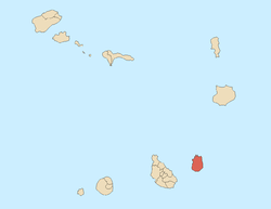 | |
| Parishes | ||
| Mountains | ||
| Other geographical features | ||
This article is issued from
Wikipedia.
The text is licensed under Creative Commons - Attribution - Sharealike.
Additional terms may apply for the media files.