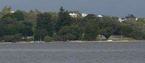
Point Walter
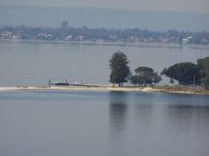
Point Walter is a point in the Swan River, Western Australia. It is located on the southern shore and forms the western end of Melville Water. Point Walter is located in the suburb of Bicton, approximately 12 kilometres south from the Perth Central Business District and 7 kilometres North East of Fremantle, and is on the opposite side of the river to the suburbs of Mosman Park, Peppermint Grove, and Dalkeith. It is popularly used for kitesurfing, windsurfing, fishing, passive recreation, swimming, diving courses[1] and picnicking.[2] The location is notable for the large sandbar which extends into the River.
History
Early history
Point Walter was named in honour of Sir James Stirling's favourite older brother, Walter Stirling in 1827 during his survey of suitable spots for settlement along the Swan River. The land was then acquired by the settlers Lionel Lukin and Alfred Waylen. After acquiring the land, Waylen developed it by building a villa which later burnt down, and in 1831 his land was extended 700 more acres to include part of the suburb to which he is the namesake, Alfred Cove. At this time the land was being used by the general public for crabbing, camping, swimming and picnicking who got to the area solely by boat, as this was the only means of access, so a jetty was subsequently built. At this time Point Walter was very popular, and to deal with ferries and yachting parties two tearooms and a timber bathing house were constructed as well as a tavern known as 'The Halfway House' due to its location between Perth and Fremantle. By 1915, a tram way had been constructed between Canning Road and Point Walter, and later a limestone road was constructed allowing access by horse drawn carriages. In 1895 or 1907 the State Government purchased the land, declaring it a Class A reserve, with several years later in 1912 the Melville Roads Board appointed to manage it. The reserve's official opening occurred on the 30th of November 1914.[3]

The decline
With the introduction of the Fremantle-Perth railway, Point Walter suffered a drop in patronage, becoming a "quiet backwater". Steamers going along the Swan River stopped using the narrow and shallow channel which had been cut into the sandbar for ease of access, and instead traveled the full way around the sandbar, costing a drop in popularity for the tearooms. A further decline in use came due to increased use of ocean beaches by the public, and as a result control was passed in 1929 to the Parks and Gardens Board. Further troubles came with the Depression of the 1930s with another drop in recreational use and yet another with World War II, and as a result Point Walter fell into a state of disrepair.[3]
Post World War II to modern day
The state of disrepair continued until the reserve was again put in the hands of the Melville Roads Board, which made several alterations to the site including all old buildings being removed, the river beach being destroyed, and new changing rooms, toilet facilities and a kiosk being built. During this time following World War II to the site served as a Migrant Settlement Hostel/Camp from 1948-1972. Post 1972 the facilities were used by the Department of Education to home the Graylands Teachers College. Control of 6.5 hectares of the land which had been used for army training purposes were handed over to the Department of Sport and Recreation in 1980, which in 1986 removed all remaining hostel buildings and spent a considerable sum developing land to the sport and recreational facilities seen today, with the official reopening occurring on 26 September 1986. The facilities first patrons were the members of the Costa Smerelda Yacht Club - the Italian syndicate that participated in the Fremantle hosted American Cup. In 2005 the facilities were once again refurbished with funding from DRS Capital Works Program.[4] Point Walter is currently managed by the Melville Council.[3]
The sandbar
Point Walter is notable for the sand bar or spit that extends over 1 km into the river, sections of which are often submerged under high water. The sandbar is prevalent in the Dreamtime of the local Aboriginals, the Beeliar family, who were part of the Whadjuk Noongars. The group believed the sandbar was the hair of the Charnok woman Junda and the nearby cliffs at Blackwall Reach were her footprints. The Charnok woman is said to have carried spirit children in her hair, who, when they fell out, formed rocks. When she reached Wave Rock, she jumped off it into the sky, with her hair forming the Milky Way and the spirit children forming the stars. The area was known to Aboriginals as Dyoondalup/Dyundalup, meaning in Noongar 'Place of Long Flowing White Hair' or 'Place of white sand'.[5] Blackwall Reach is known to the Aboriginals as Jenalup, a word meaning 'The Place Where Feet Make a Track.' It was a woman's place, and when the group wanted to move to another part of the river, the men would swim across the river to the sandbank, where they would meet the women, as it was a meeting place.[6] Aboriginal Australians would also often practice controlled burning at the site, which kept the understory low and also functioned as an effective tool for flushing out game.
The Sandbar is home to the nesting grounds of several bird species. They include the Pied Oystercatchers, the Red-Capped Plovers, Black Swans and the Fairy Tern. The local government has made a conservation effort with the campaign 'Don't Buzz That Bird', telling people not to get too close to them.[7]
Events and infrastructure
Point Walter is the site of various cultural monuments and activities, including a war memorial avenue and the free Point Walter concert, featuring people such as James Morrison.[8] In the past the venue has hosted the 'YAC it up', which featured Birds of Tokyo and Bob Evans.[9][10] Point Walter also contains Walters River Café.[11]
Erosion
In 2012 Natural Area Management was contracted by the City of Melville to undergo reversal of erosion that had occurred over the last 10 years due to losses of beaches and grassed areas, factors aided by the undercutting of tree roots. Through finishing initial works in 2013, the area was completed in early 2014.[2]
References
- ↑ "Point Walter see and do".
- 1 2 "Project Point Walter".
- 1 2 3 "Point Walter Reserve, Point Walter Golf Course and Blackwall Reach Reserve". Heritage Council - State Heritage Office.
- ↑ "Point Walter Recreation and Conference Centre" (PDF).
- ↑ "Point Walter Blackwall Reach".
- ↑ "Point Walter Aboriginal History".
- ↑ "Don't Buzz The Birds" (PDF).
- ↑ "Point Walter Concert".
- ↑ "YAC it up Point Walter Reserve Bicton".
- ↑ "YAC It Up Turns It Up for its 10th Birthday". City of Melville. 7 February 2008. Retrieved 26 October 2013.
- ↑ "Point Walter Reserve Weekend Notes".
- Melville (W.A. : Municipality). Council.(2004) Blackwall Reach and Point Walter Bushland management plan Booragoon, W.A.: City of Melville.
- Turner, Ric (1986) Point Walter : a history from corroboree to cup for Western Australian Government, Department for Sport and Recreation. Floreat Park [W.A.]
External links
Coordinates: 32°00′40″S 115°47′12″E / 32.0112°S 115.7866°E