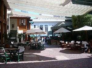
Plaza Mulato Gil de Castro

Plaza Mulato Gil de Castro is located in Barrio Lastarria, between Plaza Baquedano, Parque Forestal and Cerro Santa Lucía in Santiago, Chile. A popular destination for tourists and locals alike, the area is known for its cultural offerings and hosts a number of cafés, bookstores, museums, galleries, cultural centers, theaters and bars in its surrounds.[1] The plaza itself provides access to a cultural center featuring both a visual arts and archeological museum.[2]
Metro stations Universidad Católica ![]() and Bellas Artes
and Bellas Artes ![]() offer direct access to Barrio Lastarria.
offer direct access to Barrio Lastarria.
Origin and Development
As with many neighborhoods in Santiago’s center, Barrio Lastarria was built around a church: the Iglesia de la Veracruz. Houses were built between the winding streets, notably the house of Gil de Castro, built in the beginning of the 19th century, which stands next to the plaza. Despite the neighborhood’s early origins, the plaza was only built in 1981 due to interest in preserving a series of facades beginning at the historic house of Gil de Castro.[3]
During the 1990s, the neighborhood began a process of restoration with care not to alter its bohemian and intellectual flavor, with a number of cafés, bars and cultural centers appearing towards the end of the decade and the restoration of facades of the Church of Vera Cruz in 2001 and 2002.[4]
Since then, as an historic area in Santiago, it has been able to maintain its traditional character despite new development.
See also
References
- ↑ "What to do in the Barrio Lastarria". This is Chile. 30 December 2009. Retrieved 12 November 2012.
- ↑ Objetivos. MAVI: Museum of Visual Arts (in Spanish).
- ↑ La cultura urbana y los estilos de vida en la revitalizacion de un barrio patrimonial del centro histórico de Santiago. El caso Lastarria-Bellas Artes. Doctorate thesis, Christian Matus Madrid, Pontificia Universidad Católica de Chile. Faculty of Architectural Design and Urban Studies. 2010. p.160.
- ↑ Acerca del Barrio Lastarria. Barriolastarria.com. Retrieved 28 November 2012.
External links
| Wikimedia Commons has media related to Plaza Mulato Gil de Castro. |
- Barrio Lastarria Tourist and Cultural Information Portal
- 360° Panorama of Plaza Mulato Gil | Flip360
Coordinates: 33°26′16.38″S 70°38′26.84″W / 33.4378833°S 70.6407889°W