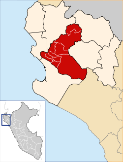
Piura Province
| Piura | ||
|---|---|---|
| Province | ||
| ||
 Location of Piura in the Piura Region | ||
| Country | Peru | |
| Region | Piura | |
| Founded | March 20, 1861 | |
| Capital | Piura | |
| Government | ||
| • Mayor | Jose Eugenio Aguilar Santisteban | |
| Area | ||
| • Total | 6,211.61 km2 (2,398.32 sq mi) | |
| Elevation | 29 m (95 ft) | |
| Population | ||
| • Total | 642,428 | |
| • Density | 100/km2 (270/sq mi) | |
| UBIGEO | 2001 | |
| Website |
www | |
Piura is a landlocked province in the Piura Region in northwestern Peru. Its capital, the city of Piura, is also the regional capital. The province is the most populous in the region as well as its center of economic activity.
Boundaries
- Northeast Sullana Province
- Northwest Ayabaca Province
- East Morropón Province
- Southeast Lambayeque Region
- Southwest Sechura Province
- West Paita Province
Political division
The Piura Province is divided into nine districts (Spanish: distritos, singular: distrito), each of which is headed by a mayor (alcalde). The districts, with their capitals in parenthesis, are:
- Piura (Piura), in Piura metropolitan area
- Castilla (Castilla), in Piura metropolitan area
- Veintiséis de Octubre, in Piura metropolitan area
- Catacaos (Catacaos), in Piura metropolitan area
- Cura Mori (Cucungará)
- El Tallán (Sinchao)
- La Arena (La Arena)
- La Unión (La Unión)
- Las Lomas (Las Lomas)
- Tambo Grande (Tambo Grande)
External links
- (in Spanish) Municipalidad Provincial de Piura - Piura provincial municipality
- (in Spanish) Documental Piura: Provincia de Piura
Coordinates: 5°11′36″S 80°37′59″W / 5.19333°S 80.63306°W
This article is issued from
Wikipedia.
The text is licensed under Creative Commons - Attribution - Sharealike.
Additional terms may apply for the media files.
